
East Hemet is a census-designated place (CDP) in Riverside County, California, United States, located east of Hemet. East Hemet is in an unincorporated area outside the city limits of Hemet. The population was 17,418 at the 2010 census, up from 14,823 at the 2000 census.

Winchester is a census-designated place (CDP) in Riverside County, California, USA. As of the 2010 census, the CDP had a total population of 2,534, up from 2,155 at the 2000 census.

Lake Hemet is a water storage reservoir located in the San Jacinto Mountains in Mountain Center, Riverside County, California, with a capacity of 14,000 acre-feet (17,000,000 m3) of water. It was created in 1895 with the construction of Lake Hemet Dam. Originally built by a private company, today it is owned and operated by the Lake Hemet Municipal Water District (LHMWD).
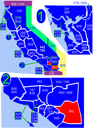
Area code 951 is a telephone area code in the North American Numbering Plan for western Riverside County in the southern part of the U.S. state of California. It was assigned in 2004 to a new numbering plan area that was created by an area code split of area code 909.
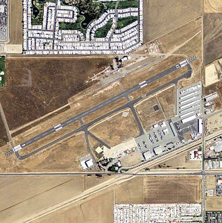
Hemet-Ryan Airport is three miles (6 km) southwest of Hemet, in Riverside County, California.

The San Jacinto River is a 42-mile-long (68 km) river in Riverside County, California. The river's headwaters are in Santa Rosa and San Jacinto Mountains National Monument. The lower portion of the 765-square-mile (1,980 km2) watershed is urban and agricultural land. As a partially endorheic watershed that is contiguous with other Great Basin watersheds, the western side of the San Jacinto Basin is a portion of the Great Basin Divide.

California's 45th congressional district is a congressional district in the U.S. state of California currently represented by Republican Michelle Steel. It was one of 18 districts that would have voted for Joe Biden in the 2020 presidential election had they existed in their current configuration while being won or held by a Republican in 2022.

The Hemet Maze Stone is a prehistoric petroglyph. It is just outside Hemet in Reinhardt Canyon, within the Lakeview Mountains, in Riverside County, California. On April 16, 1956, Mr. and Mrs. Rodger E. Miller donated the stone, along with 5.75 acres (23,300 m2) of associated land, to Riverside County. It is California Historical Landmark No.557. The government installed two perimeter chain link fences around the petroglyph landmark for protection.
Tucker Wildlife Sanctuary is a non-profit nature reserve on the Santa Ana Mountains in Orange County, California, in the United States. It is located near the end of Modjeska Canyon, at the foot of Modjeska Peak, and adjacent to the Cleveland National Forest. The Sanctuary is owned and operated by the Environmental Nature Center (ENC). The nearest community is the city of Lake Forest.
French Valley is a region located in southwestern Riverside County, near the cities and communities of Hemet, Winchester, Murrieta, and Temecula in the state of California, United States. It is part of the Plains of Leon, contiguous with the Perris Plain, that drains into the Temecula Basin by means of tributaries of the Santa Margarita River.

The San Jacinto Fault Zone (SJFZ) is a major strike-slip fault zone that runs through San Bernardino, Riverside, San Diego, and Imperial Counties in Southern California. The SJFZ is a component of the larger San Andreas transform system and is considered to be the most seismically active fault zone in the area. Together they relieve the majority of the stress between the Pacific and North American tectonic plates.
Pasinogna is a former Tongva-Gabrieleño Native American settlement in San Bernardino County, California.

The San Jacinto Valley is a valley located in Riverside County, in Southern California, in the Inland Empire. The valley is located at the base of the San Jacinto Mountains in the east and Santa Rosa Hills to the south with the San Gorgonio Pass to the north. The average elevation is 1,500 feet (460 m), with the highest points in the foothills south of Hemet and the western slopes of the San Jacinto Mountains. It is home to two cities, Hemet and San Jacinto, and several unincorporated communities. According to the 2020 census, the valley has a combined population of over 190,000 residents, including more than 143,000 residents within the city limits of Hemet and San Jacinto. The valley is also where the story and play "Ramona" was set; the story was written after author Helen Hunt Jackson visited the valley in the 1880s. The valley is also known for being an area of agriculture, which has given way to more urbanized development.

Temescal Creek is an approximately 29-mile-long (47 km) watercourse in Riverside County, in the U.S. state of California. Flowing primarily in a northwestern direction, it connects Lake Elsinore with the Santa Ana River. It drains the eastern slopes of the Santa Ana Mountains on its left and on its right the western slopes of the Temescal Mountains along its length. With a drainage basin of about 1,000 square miles (2,600 km2), it is the largest tributary of the Santa Ana River, hydrologically connecting the 720-square-mile (1,900 km2) San Jacinto River and Lake Elsinore watersheds to the rest of the Santa Ana watershed. However, flowing through an arid rain shadow zone of the Santa Ana Mountains, and with diversion of ground water for human use, the creek today is ephemeral for most of its length, except for runoff from housing developments and agricultural return flows.
Dana Point State Marine Conservation Area

Laguna Beach State Marine Reserve (SMR) and Laguna Beach State Marine Conservation Area (SMCA) are two adjoining marine protected areas that extend offshore of Laguna Beach in Orange County on California’s south coast. The SMR covers 6.27 square miles, and the SMCA covers an additional 3.44 square miles. These two MPAs are part of a four-MPA complex on the coast of southern Orange County. Each protects marine life by prohibiting or limiting the removal of marine wildlife from within its borders.

Temescal Mountains, also known as the Sierra Temescal, are one of the northernmost mountain ranges of the Peninsular Ranges in western Riverside County, in Southern California in the United States. They extend for approximately 25 mi (40 km) southeast of the Santa Ana River east of the Elsinore Fault Zone to the Temecula Basin and form the western edge of the Perris Block.
The Perris Block is the central block of three major fault-bounded blocks of the northern part of the Peninsular Ranges. The Perris Block lies between the Santa Ana Block to the west and the San Jacinto Block to the east. The Perris Block, was named by Walter A. English in 1925 for the city of Perris, located near the center of the block.
Bee Canyon Wash is a stream located in the U.S. state of California. It is located in Orange County. It is located at the coordinates 33.6541883°N, -117.7586647°W. It is located close to East Irvine, Shady Canyon and Bommer Canyon.
