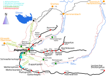
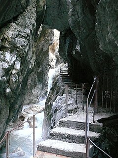
The Reintal ("Rein Valley") is the name given to the upper and lower valleys of the River Partnach between the Zugspitzplatt plateau and the Partnachklamm gorge. A hiking route to Germany's highest mountain, the Zugspitze runs through the valley.

The Partnach is an 18 km (11 mi) long mountain river in Bavaria, Germany.

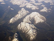
The Zugspitze, at 2,962 m (9,718 ft) above sea level, is the highest peak of the Wetterstein Mountains as well as the highest mountain in Germany. It lies south of the town of Garmisch-Partenkirchen, and the Austria–Germany border runs over its western summit. South of the mountain is the Zugspitzplatt, a high karst plateau with numerous caves. On the flanks of the Zugspitze are three glaciers, including the two largest in Germany: the Northern Schneeferner with an area of 30.7 hectares and the Höllentalferner with an area of 24.7 hectares. The third is the Southern Schneeferner which covers 8.4 hectares.
Contents
The valley was formed during the Würm Ice Age by the Reintal Glacier and then deepened by the Partnach in the post-ice age period after the retreat of the glacier to the periphery of the Schneefernerkopf mountain. The upper Reintal, which was shaped by the glacier and today forms a U-shaped glacial valley, ends between the Hohe Gaifkopf in the west and the Schachen in the east. The lower Reintal lies in the area of the former glacial lake of the Loisach Glacier, into which the Reintal Glacier flowed from the southwest. It is a V-shaped valley and has been predominantly shaped by the Partnach river.

The Schneefernerkopf is a 2,875-metre-high (9,432 ft) peak in the Zugspitze massif in the Alps. It lies at the western end of the Wetterstein chain in the Alps on the border between the German state of Bavaria and the Austrian state of Tyrol. It is the dominant mountain in the Wetterstein, especially when viewed from Ehrwald.
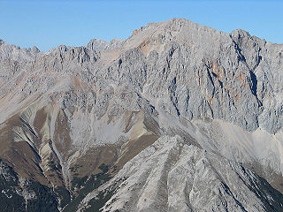
Together with the Höllental valley to the north, the Reintal divides the Wetterstein Mountains into several ridges. The northern periphery is formed by the arêtes of the Höllentalspitzen (2,743 m) and the Hohe Gaifkopf (1,864 m). The highest points on the southern flank of the valley lie on the Hochwanner (2,744 m), the Hinterreintalschrofen (2,670 m) and the Dreitorspitze (2,682 m). The valley floor lies at elevations between 1400 m above NN at the source of the Partnach river, 1,002 m at the entrance to the gorge of the Hinteren Klamm and 797 m at the start of the Partnachklamm gorge, in the upper Reintal therefore about 1300 to 850 m above the surrounding mountain peaks. [?] In the upper Reintal the rubble from rockslides from the southern faces of the Hochwanner and Hinterreintalschrofen also play a rôle in the shaping of the valley. These have spilled into the old glacial valley, forced back the course of the Partnach to the north and, in places, impounding it.
The Höllental, English translation "Hell Valley" or "Valley of Hell" is one of the routes on the German side leading up the Zugspitze on the German-Austrian border in the northern Alps. It is located in the district of Garmisch-Partenkirchen.

An arête is a narrow ridge of rock which separates two valleys. It is typically formed when two glaciers erode parallel U-shaped valleys. Arêtes can also form when two glacial cirques erode headwards towards one another, although frequently this results in a saddle-shaped pass, called a col. The edge is then sharpened by freeze-thaw weathering, and the slope on either side of the arete steepened through mass wasting events and the erosion of exposed, unstable rock. The word ‘arête’ is actually French for edge or ridge; similar features in the Alps are described with the German equivalent term Grat.
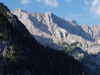
The Höllentalspitzen are three peaks in the Wetterstein Mountains near Garmisch-Partenkirchen in southern Germany. They rise from the ridge of Blassenkamm which runs eastwards from Germany's highest peak, the Zugspitze, and separate the Hölle Valley to the north from the Reintal Valley to the south. The summit nearest to the Zugspitze is the Inner Höllentalspitze, 2,741 metres (8,993 ft) high; this is followed by the main summit Middle Höllentalspitze, 2,743 metres (8,999 ft) high; and the Outer Höllentalspitze at 2,720 metres (8,920 ft).
Around 1800 rockslides created two small lakes, the Vordere Blaue Gumpe and Hintere Blaue Gumpe . On 23 August 2005 the former was completely filled with sediment as a result of heavy rain (200mm in 24h) whereupon high pressure broke the natural dam. The resulting deluge of flood water caused considerable damage further down the valley. [1] [2]
A moderately steep climbing path to the Zugspitze runs through the Reintal, the section as far as the Knorr Hut forming part of the Red Trail of the Via Alpina. The mountain huts in the valley, the Bock Hut and Reintalanger Hut, are used by hikers and climbers as bases for numerous tours.

The Knorr Hut is a mountain hut belonging to the German Alpine Club and located in the Wetterstein Mountains at a height of 2,052 m. Its lies right on the edge of the Zugspitzplatt where it drops into the Reintalanger in a location with scenic views and is an important base for hikers who can climb up to it on the normal route from the town of Garmisch-Partenkirchen through the Reintal valley to Germany’s highest mountain, the Zugspitze.
The Via Alpina is a network of five long-distance hiking trails across the alpine regions of Slovenia, Austria, Germany, Liechtenstein, Switzerland, Italy, France, and Monaco. The longest of trails is the red trail, whose termini are in Trieste and Monaco.

The Reintalanger Hut (1,366 m) is an Alpine Club hut in the Wetterstein Mountains at the head of the Reintal valley. The River Partnach has its source in the vicinity. West of the hut the valley floor climbs steeply up to the plateau of the Zugspitzplatt below Germany's highest mountain.
Due to its great distance from any settlements and because no roads runs up the valley the Reintal is very unspoilt and still very natural, despite being easily accessible on foot. Together with the Wimbachtal in the Berchtesgadener Land it may be considered as one of the most impressive, large, near-natural valley landscapes in the Bavarian Alps. The upper Reintal is protected as a nature reserve.

Berchtesgadener Land is a Landkreis (district) in Bavaria, Germany. It is bounded by the district of Traunstein and by the state of Austria.

Bavarian Alps is a summarizing term of several mountain ranges of the Northern Limestone Alps in the German state of Bavaria.

A nature reserve is a protected area of importance for flora, fauna or features of geological or other special interest, which is reserved and managed for conservation and to provide special opportunities for study or research. Nature reserves may be designated by government institutions in some countries, or by private landowners, such as charities and research institutions, regardless of nationality. Nature reserves fall into different IUCN categories depending on the level of protection afforded by local laws. Normally it is more strictly protected than a nature park.