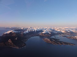
Rødøy is a municipality in Nordland county, Norway. It is part of the Helgeland traditional region. The administrative centre of the municipality is the village of Vågaholmen. Other villages include Gjerøy, Jektvika, Kilboghamn, Melfjordbotn, Oldervika, Sørfjorden, and Tjong. The municipality consists of many islands to the west of Norway's second biggest glacier, Svartisen.

Bolga is an island in the municipality of Meløy in Nordland county, Norway. The 2.4-square-kilometre (0.93 sq mi) island has a population (2017) of 105. It is located west of the islands of Meløya and Åmnøya, just off the coast of the Helgeland region. The highest point on the island is the 339-metre (1,112 ft) tall Bolgtinden. Most of the population of the island lives along the eastern shore in the village that is also known as Bolga. It is the only village on the island. There are regular ferry connections from Bolga to the islands of Meløya to the east and to Vassdalsvik and Ørnes on the mainland.

Glomfjord is a village in the municipality of Meløy in Nordland county, Norway. The industrial community is located along Norwegian County Road 17 at the head of the Glomfjorden, just north of the Arctic Circle. The 1.14-square-kilometre (280-acre) village has a population (2018) of 1,077 and a population density of 945 inhabitants per square kilometre (2,450/sq mi).

Ørnes is the administrative centre of the municipality of Meløy in Nordland county, Norway. The old village is mentioned in documents dating from 1610 when a tenant farmer lived here. It is located along Norwegian County Road 17, about 6 kilometres (3.7 mi) south of the village of Reipå and about 5 kilometres (3.1 mi) north of the village of Eidbukta. The island of Mesøya lies just west of the village. Ørnes is a port of call along the Hurtigruten ferry route between Nesna and Bodø. The newspapers Framtia and Meløyavisa are published in Ørnes.

Bjerka is a village in the municipality of Hemnes in Nordland county, Norway. It is located along the European route E06 highway and the Nordland Line, about 20 kilometres (12 mi) southeast of Hemnesberget and about 7 kilometres (4.3 mi) north of the municipal center of Korgen.
Lysvatnet is a lake that lies in the municipality of Meløy in Nordland county, Norway. The 4.53-square-kilometre (1.75 sq mi) is located near the border with Gildeskål Municipality, about 5.5 kilometres (3.4 mi) east of the municipal centre of Ørnes. The lake Markavatnet lies about 3 kilometres (1.9 mi) to the west of this lake.
Markavatnet or Markvatnet is a lake that lies in the municipality of Meløy in Nordland county, Norway. The 2.28-square-kilometre (0.88 sq mi) lake is located about 4 kilometres (2.5 mi) east of the village of Reipå and the same distance north of the municipal centre of Ørnes. The lake Lysvatnet lies about 3 kilometres (1.9 mi) to the east of Markavatnet.
Trofors is the administrative centre of the municipality of Grane in Nordland county, Norway. It is located at the confluence of the rivers Austervefsna and Svenningdalselva which forms the large river Vefsna. The village of Leiren lies about 25 kilometres (16 mi) to the southeast and the village of Majavatn lies about 45 kilometres (28 mi) to the south.
Storforshei is a village in the Dunderland Valley in the municipality of Rana in Nordland county, Norway. The village is located along the river Ranelva, about 25 kilometres (16 mi) northeast of the town of Mo i Rana. The European route E06 and the Nordland Line both pass through the village. The village of Nevernes and the Nevernes Church both lie about 3 kilometres (1.9 mi) to the south.
Alsvåg is a village in the municipality of Øksnes in Nordland county, Norway. It is located on the western bank of the Gavlfjorden on the island of Langøya and about 8 kilometres (5.0 mi) east of the municipal centre of Myre. Alsvåg Church is located in this village.

Myre is the administrative centre of Øksnes Municipality in Nordland county, Norway. It is located on the northwestern part of the island of Langøya in the Vesterålen archipelago. Myre is one of the largest fishing villages in the Vesterålen region. Myre Church is located in this village.
Ågskardet is a village in the municipality of Meløy in Nordland county, Norway. It is located on the southern side of the Holandsfjorden, about 3.5 kilometres (2.2 mi) north of the village of Tjong. There were 127 inhabitants in 2008.
Mesøya or Mesøy is an island in the municipality of Meløy in Nordland county, Norway. The island is located just southwest of the village of Ørnes on the mainland and east of the island of Meløya. The island sits at the mouth of the Glomfjorden. Mesøya is only accessible by boat, and it has no regular ferry service. Mesøya has an area of 8 square kilometres (3.1 sq mi) and the highest point on the island is the 364-metre (1,194 ft) tall Mesøytoppen.
Eidbukta is a village in the municipality of Meløy in Nordland county, Norway. It is located along Norwegian County Road 17, about 5 kilometres (3.1 mi) south of the municipal centre of Ørnes. The village lies at the entrance to the Glomfjorden. The 0.71-square-kilometre (180-acre) village has a population (2018) of 572 and a population density of 806 inhabitants per square kilometre (2,090/sq mi).

Meløya is an island in the municipality of Meløy in Nordland county, Norway. The island lies east of the island of Bolga, north of the island of Åmnøya, and west of the island of Mesøya. The 21.8-square-kilometre (8.4 sq mi) island is only accessible by boat, and there are regular ferry connections to the nearby villages of Bolga, Støtt, Vassdalsvik, and Ørnes. The island has a population (2017) of 215.

Fore Church is a parish church of the Church of Norway in Meløy Municipality in Nordland county, Norway. It is located in the village of Reipå. It is one of the churches for the Fore og Meløy parish which is part of the Bodø domprosti (deanery) in the Diocese of Sør-Hålogaland. The white, wooden church was built in a cruciform style in 1909 by the architect O. M. Olsen. The church seats about 450 people.
Mevik is a village in the municipality of Gildeskål in Nordland county, Norway. It is located in the southwestern part of the municipality, about 4 kilometres (2.5 mi) west of the village of Storvika and about 10 kilometres (6.2 mi) northeast of the village of Reipå in the neighboring municipality of Meløy. The village is located along Norwegian County Road 17. Mevik Chapel is located in the village.

Hattfjelldal (Norwegian) or Aarporte (Southern Sami) is the administrative centre of Hattfjelldal Municipality in Nordland county, Norway. The village is located along the river Vefsna, about 25 kilometres (16 mi) west of the border with Sweden. The large lake Røssvatnet lies about 7 kilometres (4.3 mi) north of the village. The Norwegian National Road 73 runs through the village. The village of Svenskvollen lies about 25 kilometres (16 mi) to the south in the Susendalen valley. The village of Varntresk lies about 30 kilometres (19 mi) to the north.

Støttvær is a group of islands in Meløy Municipality in Nordland county, Norway. The islands lie about 10 kilometres (6.2 mi) northwest of the mainland village of Reipå. The main islands of Støttvær include the 1.6-square-kilometre (0.62 sq mi) Svenningen, the 2.7-square-kilometre (1.0 sq mi) Innerstøtt, and the 1.4-square-kilometre (0.54 sq mi) Helløya. There are also many other uninhabited smaller islands and skerries surrounding the main islands. Innerstøtt and Svenningen are inhabited and they are connected to each other by bridges. There were 27 residents in Støttvær in 2017. There is a car ferry from Innerstøtt to the mainland village of Ørnes. The two inhabited islands are also referred to as the village of Støtt.