A drumlin, from the Irish word droimnín, first recorded in 1833, and in the classical sense is an elongated hill in the shape of an inverted spoon or half-buried egg formed by glacial ice acting on underlying unconsolidated till or ground moraine.

Topography is the study of the shape and features of land surfaces. The topography of an area could refer to the surface shapes and features themselves, or a description.

In geography and geology, fluvial processes are associated with rivers and streams and the deposits and landforms created by them. When the stream or rivers are associated with glaciers, ice sheets, or ice caps, the term glaciofluvial or fluvioglacial is used.

In oceanography, geomorphology, and earth sciences, a shoal is a natural submerged ridge, bank, or bar that consists of, or is covered by, sand or other unconsolidated material, and rises from the bed of a body of water to near the surface. Often it refers to those submerged ridges, banks, or bars that rise near enough to the surface of a body of water as to constitute a danger to navigation. Shoals are also known as sandbanks, sandbars, or gravelbars. Two or more shoals that are either separated by shared troughs or interconnected by past or present sedimentary and hydrographic processes are referred to as a shoal complex.
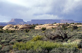
Mesa is the American English term for tableland, an elevated area of land with a flat top and sides that are usually steep cliffs. It takes its name from its characteristic table-top shape. It may also be called a table hill, table-topped hill or table mountain. It is larger than a butte, which it otherwise resembles closely.

Terrain or relief involves the vertical and horizontal dimensions of land surface. The term bathymetry is used to describe underwater relief, while hypsometry studies terrain relative to sea level. The Latin word terra means "earth."

The Cumberland Plateau is the southern part of the Appalachian Plateau in the Appalachian Mountains of the United States. It includes much of eastern Kentucky and Tennessee, and portions of northern Alabama and northwest Georgia. The terms "Allegheny Plateau" and the "Cumberland Plateau" both refer to the dissected plateau lands lying west of the main Appalachian Mountains. The terms stem from historical usage rather than geological difference, so there is no strict dividing line between the two. Two major rivers share the names of the plateaus, with the Allegheny River rising in the Allegheny Plateau and the Cumberland River rising in the Cumberland Plateau in Harlan County, Kentucky.
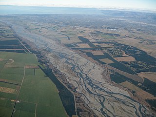
An alluvial plain is a largely flat landform created by the deposition of sediment over a long period of time by one or more rivers coming from highland regions, from which alluvial soil forms. A floodplain is part of the process, being the smaller area over which the rivers flood at a particular period of time, whereas the alluvial plain is the larger area representing the region over which the floodplains have shifted over geological time.
A relief is a sculpture where a modelled form projects from a flat background.

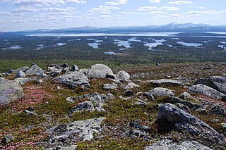
Glacial landforms are landforms created by the action of glaciers. Most of today's glacial landforms were created by the movement of large ice sheets during the Quaternary glaciations. Some areas, like Fennoscandia and the southern Andes, have extensive occurrences of glacial landforms; other areas, such as the Sahara, display rare and very old fossil glacial landforms.

A ravine is a landform that is narrower than a canyon and is often the product of streamcutting erosion. Ravines are typically classified as larger in scale than gullies, although smaller than valleys.
The geographic cycle or cycle of erosion is an idealized model that explains the development of relief in landscapes. The model starts with the erosion that follows uplift of land above a base level and ends – if conditions allow – in the formation of a peneplain. Landscapes that show evidence of more than one cycle of erosion are termed "polycyclical". The cycle of erosion and some of its associated concepts have, despite popularity, been a subject of much criticism.
A Rogen moraine is a subglacially formed type of moraine landform, that mainly occurs in Fennoscandia, Scotland, Ireland and Canada. They cover large areas that have been covered by ice, and occur mostly in what is believed to have been the central areas of the ice sheets. Rogen moraines are named after Lake Rogen in Härjedalen, Sweden, the landform's type locality. Rogen Nature Reserve serves to protect the unusual area.
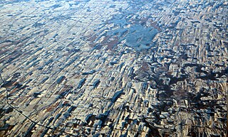
Geographical features are naturally-created features of the Earth. Natural geographical features consist of landforms and ecosystems. For example, terrain types, are natural geographical features. Conversely, human settlements or other engineered forms are considered types of artificial geographical features.

A fjard is a large open space of water between groups of islands or mainland in archipelagos. Fjards can be found along sea coasts, in freshwater lakes or rivers. Fjard and Fjord are originally the same word with the general meaning of sailable waterway. In Scandinavia fjords dominate along the North Sea coast and fjards in the Baltic Sea. Examples of fjards are Kanholmsfjärden in the Stockholm archipelago in Sweden, Hjortsholm on the coast of Denmark, Killary Harbour on the west coast of Ireland and Somes Sound in Acadia National Park, Maine.
This glossary or terminology of geography terms is a list of definitions of terms and concepts used in geography and related fields, which describe and identify natural phenomena, geographical locations, spatial dimension and natural resources. Geographical terms are classified according to their functions, such as description, explanation, analysing, evaluating and integrating.

An ingression coast or depressed coast is a generally level coastline that is shaped by the penetration of the sea as a result of crustal movements or a rise in the sea level.

Climatic geomorphology is the study of the role of climate in shaping landforms and the earth-surface processes. An approach used in climatic geomorphology is to study relict landforms to infer ancient climates. Being often concerned about past climates climatic geomorphology considered sometimes to be an aspect of historical geology. Since landscape features in one region might have evolved under climates different from those of the present, studying climatically disparate regions might help understand present-day landscapes. For example, Julius Büdel studied both cold-climate processes in Svalbard and weathering processes in tropical India to understand the origin of the relief of Central Europe, which he argued was a palimpsest of landforms formed at different times and under different climates.


