Related Research Articles

The water bodies of Azerbaijan were formed over a long geological timeframe and changed significantly throughout that period. This is particularly evidenced by remnants of ancient rivers found throughout the country. The country's water systems are continually changing under the influence of natural forces and human introduced industrial activities. Artificial rivers (canals) and ponds are a part of Azerbaijan's water systems.

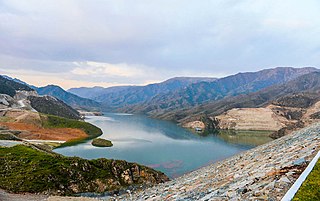
The Mingachevir reservoir or The Mingachevir sea ,) is a large reservoir in northwestern Azerbaijan. It is the largest reservoir in the Caucasus. The reservoir's filling began in 1953 and was completed in 1959.

Ujjani Dam, also known as Bhima Dam or Bhima Irrigation Project, on the Bhima River, a tributary of the Krishna River, is an earthfill cum Masonry gravity dam located near Ujjani village of Madha Taluk in Solapur district of the state of Maharashtra in India.
Owyhee Dam is a concrete arch-gravity dam on the Owyhee River in Eastern Oregon near Adrian, Oregon, United States. Completed in 1932 during the Great Depression, the dam generates electricity and provides irrigation water for several irrigation districts in Oregon and neighboring Idaho. At the time of completion, it was the tallest dam of its type in the world. The dam is part of the Owyhee Dam Historic District, which is listed on the National Register of Historic Places.

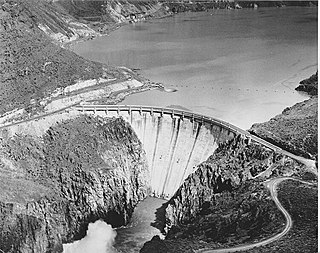
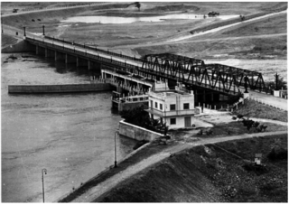
The Mingachevir Dam is an earth-fill embankment dam on the Kura River just north of Mingachevir in Azerbaijan. It serves several purposes to include hydroelectric power production and water storage for irrigation. The Mingachevir reservoir, behind the dam, supplies water to the Upper Qarabag and Upper Sirvan Channels which help irrigate about 1,000,000 ha of farmland in the country. Its six Francis turbine-generators were overhauled or replaced with 70 megawatts (94,000 hp) sets in 2000. Mingachevir reservoir has a storage capacity of 15.730 cubic kilometres (12,753,000 acre⋅ft), covering 605 km2 (234 sq mi). The length of the dam is 1,550 metres (5,090 ft), its width is 16 metres (52 ft) and height is 80 m (260 ft). It is the largest hydroelectric power station in the South Caucasus, is located over Kur river and not far from Mingachevir city.
Two-thirds of energy in Azerbaijan comes from fossil gas and almost a third from oil. Azerbaijan is a major producer of oil and gas, much of which is exported. Most electricity is generated by gas-fired power plants.
The Shamkir reservoir is a large reservoir in the Shamkir Rayon of northwestern Azerbaijan. It is the second largest reservoir in the Caucasus after the Mingachevir reservoir.

The Tartar is one of the tributaries of the Kura located in Azerbaijan. It passes through the districts of Kalbajar, Barda and Tartar. Parts of the river flows through the self-proclaimed Republic of Artsakh's Martakert Province.
The Aghstafachay reservoir is a large reservoir in the Aghstafa District of northwestern Azerbaijan.
Khanbulanchay reservoir, also known as Khanbulaqchay reservoir, is a lake in Lankaran Rayon of southeastern Azerbaijan. The name means "the spring of the khan" in Azerbaijani language.
The Yenikend reservoir is a large reservoir in the Shamkir Rayon of northwestern Azerbaijan. It is the third largest reservoir in the Caucasus after the Mingachevir and Shamkir reservoirs.
Jeyranbatan reservoir is a reservoir in the Absheron Rayon in eastern part of Azerbaijan. It is located between Baku and Sumgayit cities, next to Ceyranbatan settlement 20 km away from Baku. In Azerbaijani Jeyranbatan means "the place where the gazelle has drowned" which refers to an ancient legend related to the naming of city of Sumgayit.
Samur–Absheron channel is an irrigation channel in Azerbaijan flowing from Russia-Azerbaijan border to the Jeyranbatan reservoir.
The Varvara reservoir is a reservoir near Mingachevir, Azerbaijan.

Akhurian Reservoir is a reservoir on the Akhurian River between Armenia and Turkey. The reservoir has a surface area of 54 km² and a volume of 525 million cubic meters. It is one of the largest reservoirs in the Caucasus, smaller than the Mingachevir reservoir and the Shamkir reservoir in Azerbaijan.
The Azerbaijan is a country with very favorable natural conditions and rich natural resources. Snowy peaks, high mountains, foothill fertile soils, wide plains, Lowest Land Points Below Ocean Level are the main landscape forms of republic. This complex landscape structure has caused the variety in natural conditions - climate, soil-vegetation, and water resources. This, in turn, led to the uneven distribution of population and farms on the territory, and the specialization of production on different types.
National Policy Dialogues on Integrated Water Resources Management in Azerbaijan for managing water resources are aimed at developing a state strategy based on "Convention on the Protection and Use of Transboundary Watercourses and International Lakes" of United Nations Economic Commission for Europe and European Union Water Framework Directive and the "Water and Health" Protocol of that convention as well as other principles of the United Nations and the EU.
Shamkirchay reservoir is an artificial reservoir in the Shamkir district of Azerbaijan. It is located on the slope of the Lesser Caucasus on the Shamkirchay river. The volume of the reservoir is 164.5 million m³. Useful volume considered - 156.3 million m³.

Zogalavachay reservoir is a reservoir located on the Zogalavachay river in the Shamakhi district of the Republic of Azerbaijan, in southwest of the city of Shamakhi.
References
- ↑ "Озеры и водохранилища Азербайджана". www.ksam.org. Retrieved 2018-07-30.
- ↑ Nations, United (2009-11-14). Our Waters: Joining Hands Across Borders: First Assessment of Transboundary Rivers Lakes and Groundwater (in Russian). United Nations Publications. ISBN 9789214160335.
- ↑ Rustamov, S. G.; Кашкай, Р. М. (1978). Водный баланс Азербайджанской ССР (in Russian). ĖЛМ.
- 1 2 Мусаев, М. А.; наук), М. А. Мусаев (доктор ветеринарных; Касымов, Абдул Гусейнович; Абдурахманов, Ю. А. (1975). Биологические ресурсы внутренних водоемов Азербайджана (in Russian). Элм.
- ↑ Nations, United (2006-09-08). Sotrudnichestvo po transgranichnym vodam: tendentsii v novykh nezavisimykh gosudarstvakh (in Russian). United Nations Publications. ISBN 9789214160120.
- 1 2 Azərbaycanın su anbarları və daxili suları
- ↑ "Азербайджан :: Водохранилища". garabagh.net (in Azerbaijani). Archived from the original on 2018-07-30. Retrieved 2018-07-30.