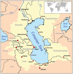
Azerbaijan is a country in the Caucasus region, situated at the juncture of Eastern Europe and West Asia. Three physical features dominate Azerbaijan: the Caspian Sea, whose shoreline forms a natural boundary to the east; the Greater Caucasus mountain range to the north; and the extensive flatlands at the country's center. About the size of Portugal or the US state of Maine, Azerbaijan has a total land area of approximately 86,600 km2, less than 1% of the land area of the former Soviet Union. Of the three Transcaucasian states, Azerbaijan has the greatest land area. Special administrative subdivisions are the Nakhchivan Autonomous Republic, which is separated from the rest of Azerbaijan by a strip of Armenian territory, and the Nagorno-Karabakh Autonomous Region, entirely within Azerbaijan. The status of Nagorno-Karabakh is disputed by Armenia, but is internationally recognized as territory of Azerbaijan.

The Kura is an east-flowing river south of the Greater Caucasus Mountains which drains the southern slopes of the Greater Caucasus east into the Caspian Sea. It also drains the north side of the Lesser Caucasus, while its main tributary, the Aras, drains the south side of those mountains. Starting in northeastern Turkey, the Kura flows through Turkey to Georgia, then to Azerbaijan, where it receives the Aras as a right tributary, and enters the Caspian Sea at Neftçala. The total length of the river is 1,515 kilometres (941 mi).

The Aras is a river in the Caucasus. It rises in eastern Turkey and flows along the borders between Turkey and Armenia, between Turkey and the Nakhchivan exclave of Azerbaijan, between Iran and both Azerbaijan and Armenia, and, finally, through Azerbaijan where it flows into the Kura river. It drains the south side of the Lesser Caucasus Mountains, while the Kura drains the north side of the Lesser Caucasus. The river's total length is 1,072 km (666 mi) and its watershed covers an area of 102,000 km2 (39,000 sq mi). The Aras is one of the longest rivers in the Caucasus.
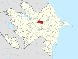
Goychay District is one of the 66 districts of Azerbaijan. Located in the centre of the country, it belongs to Central Aran Economic Region. The district borders the districts of Agdash, Qabala, Ismayilli, Kurdamir, and Ujar. Its capital and largest city is Goychay. As of 2020, the district had a population of 121,700. It is famous for its pomegranate growing industry, and for its pomegranate festival.

Fauna of Azerbaijan or animal kingdom of Azerbaijan refers to the diversity of various types of animals, which inhabit and populate a defined ground or water area in Azerbaijan.

The environment of Azerbaijan, includes a wide diversity of climates, animals, plants, and habitats.

Orography of Azerbaijan refers to the rocky, mountainous and elevated terrains in Azerbaijan. The tectonic structure is typical for the orography of the country. The main morphostructural units are the Greater Caucasus, the Lesser Caucasus, the Gusar plane, the Samur-Devechi lowland, the Kur intermountain trough, the Karabagh volcanic highland, the near and middle Araz Ridges and Talysh Mountains.

The climate of Azerbaijan is very diverse. Nine out of eleven existing climate zones are present in Azerbaijan.
Flora of Azerbaijan or Vegetation of Azerbaijan refers to the plants, trees and flowers which can be found in Azerbaijan.
National parks of Azerbaijan are run by the Ministry of Ecology and Natural Resources in the Republic of Azerbaijan. The first national park established was Zangezur National Park in 2003. Since then, a further 9 national parks have been established; the most recent being the Gizilaghaj National Park in 2018.
Mil plain is a plain in Azerbaijan. It is located on the bank of the Aras river and extends to Iran. Mil-plain is located in the southwest part of the Kur-Araz lowland, where the Kura and Araz rivers meet. The area is between the right bank of the Kura River and the left bank of the Araz River. The north-eastern part of the plain is lower than the ocean level. In the south-west, these areas are covered by sand, gravel. More than 40 percent of the altitude in the plain is 0–100 meters, 25 percent - 100–200 meters above sea level, and 35 percent - absolute altitude is less than 0 meters. The absolute altitude decreases about 8 m to north and varies from 200 to 250 to the west. The plain includes mainly the areas of Imishli and Beylagan districts. Seismic activity is high as the plain is in the convergent border the Alpine-Himalayan orogenic belt.
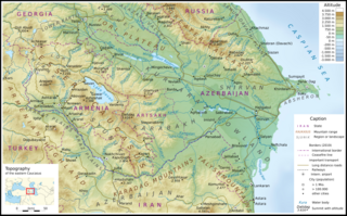
The Kura-Aras Lowland, Kura-Aras Depression or Kura-Aras Basin is a vast depression in central-southern Azerbaijan defined by the valleys of the Kura River and Aras River. It is situated by the West shore of the Caspian Sea and is part of the Aral-Caspian Depression. It is delimited by the Greater Caucasus from the North, Lesser Caucasus from the West and the Talysh Mountains from the South. The name is derived from the names of the two rivers in the area: the Kura and the Aras.
Hajikabul is the sixth-largest lake of Azerbaijan.

The geology of Azerbaijan forms a constituent geological part of the Alpine fold belt. Sedimentary deposits embracing the southwestern parts of the Major and Minor Caucasus, including the intermountain Kur River trough, as well as the Mid- and South Caspian basins consist of diversity fold systems. The Earth's crust thickness in Azerbaijan varies in the range from 38 to 55 km. Its maximum thickness is observed in the Minor Caucasus area, while its minimum thickness is typical for the Talysh foothills. The geological setting of the area consists of sedimentary, volcanic-sedimentary, volcanic and terrestrial deposits embracing almost the entire stratigraphic range beginning from Pre-Cambrian through Holocene time.
The Vileshchay is a river of Azerbaijan. It is one of the larger rivers of the country, flowing into the Caspian Sea in southeastern Azerbaijan.

The total forest area of Azerbaijan is 1,021,880 ha or 11.8% of the country's area. The forest biomes consist of temperate deciduous forests, temperate broadleaf and mixed forests, temperate coniferous forests and riparian forests. Specialists estimate that in the 8th-9th centuries the forest cover was around 30-35%, most of it situated in mountainous areas.
Azerbaijan is a country with very favorable natural conditions and rich natural resources. Snowy peaks, high mountains, foothill fertile soils, wide plains, Lowest Land Points Below Ocean Level are the main landscape forms of the republic. This complex landscape structure has resulted in a variety of natural conditions, climate, soil-vegetation, and water resources. This, in turn, led to the uneven distribution of population and farms on the territory, and the specialization of production on different types.
The climate in most parts of Azerbaijan is semi-arid. In order to expand the areas of irrigation in a dry climate and to provide grape and orchards with water, many small and large reservoirs have been created. There are 140 reservoirs in the country. The total volume of reservoirs is 21.5 km3. Most reservoirs are regulated and used for irrigation. Reservoirs and hydroelectric stations created in the rivers Kura, Araz and Tartar are Shamkir, Mingachevir, Yenikend, Varvara, Araz and Sarsang. They are used to ensure the use of energy, irrigation and water supply.