Environment of Azerbaijan

Last updated
Mountains near the highest village in Azerbaijan, Khinalyg Azerbaijani Village.JPG
Mountains near the highest village in Azerbaijan, Khinalyg
Mountains of Tangaalti near Quba Landscape, Quba Rayon, Azerbaijan, summer 2007.jpg
Mountains of Tangaalti near Quba
Besh Barmag Mountain (Five Finger Mountain) is located in Absheron, Azerbaijan. Mountain Beshbarmag, Azerbaijan, 2007.jpg
Besh Barmag Mountain (Five Finger Mountain) is located in Absheron, Azerbaijan.
Ismailli State Reserve in Azerbaijan Ismailli State Reserve.jpg
Ismailli State Reserve in Azerbaijan
Kurd@mir sunset Kurd@mir sunset.JPG
Kürdəmir sunset

The environment of Azerbaijan, includes a wide diversity of climates, animals, plants, and habitats.

Contents

National protection

Due to the tapping of oil reserves in the early 20th century, Azerbaijan has had sufficient resources to develop an industrial sector, which in turn led to a significant increase in pollution. Under the centrally-planned Soviet command economy Baku became an industrialized capital city. Moscow could, for example, order that all air conditioners in the Soviet Union be built in Azerbaijan, such arbitrary and unilateral control of industrial output often led to environmental neglect and increased pollution, which caused serious damage to nature within Azerbaijan.[ citation needed ]

Since the independence of Azerbaijan, the Azerbaijani government has taken drastic measures to preserve the unique nature of Azerbaijan. But national protection of Azeri nature started truly functioning after 2001 when the state budget increased due to new revenues provided by the Baku-Tbilisi-Ceyhan pipeline. Within the last four years protected nature areas doubled to is equal to eight percent of the country's territory. The measures taken by the president were applauded by foreign organizations, in fact, President Ilham Aliyev was awarded Germany Mikhail Zhukov Fund's prize for his successful ecological policy on 19 October 2006. [1]

Since 2001 the government has set up seven large reserves and almost doubled the sector of the budget earmarked for environmental protection. [2] [3]

On October 4, 2016 Azerbaijani officials announced their plans for further improvement of the ecological situation in Baku Bay, which will take place during 2016–2020.

State Reserves of Azerbaijan

Lion's View in Gobustan Gobustan Lion VIew.jpg
Lion's View in Gobustan

The state-run nature reserves aim to protect nature, wildlife and the environment. They allow scientists to conduct natural research. They are specifically designed for the protection of common and rare species of flora and fauna. Azeri law strictly prohibits industrial development or meddling with animals or plants within the borders of the state parks.

There are 16 state natural parks in Azerbaijan that preserve and protect the fauna, flora and their ecosystems. See below for the list:

National parks

Murov mountain in Azerbaijan Murov mountain in Azerbaijan-Caucasus3.jpg
Murov mountain in Azerbaijan
Ismailli Reserve in Azerbaijan Ismaily.png
Ismailli Reserve in Azerbaijan

National Parks of Azerbaijan refers to the National Parks in the territory of Azerbaijan. National Parks have peculiarities and ensure a strong security system and all favorable conditions for animals living within the park. National Parks in Azerbaijan are restricted tourism zones but are open for observation of the natural processes. Ecotourism and other infrastructural constructions are currently being established in the national parks of Azerbaijan.

As a country located in both the Caucasus and Asia Minor, between the Black and Caspian Seas, Azerbaijan has a rich natural culture, and the widest biodiversity of all the European states and has enormous natural resources. The natural reserves play a crucial role in the preservation of this biodiversity.

Azerbaijan has a total of 7 national parks, 13 state natural parks and 21 reserves, which can be seen here below. A seventh national park the Shakhdag National Park was established in 2008, Shakhdag is the largest national park in the Caucasus and one of the largest in Europe. [4]

State Natural Game Reserve

Game Reserves are reserves with the purpose of maintaining wildlife. Some game reserves also allow hunting. The State Game Reserves in Major Caucasus in Azerbaijan are:

The natural complexes with the Minor Caucasus are:

Four State Game Reserves of Azerbaijan (Lachyn, Gubadly, Dashalty, Arazboylu with a total area of about 440 km2) are not currently operating as a result of the Armenian occupation of Azerbaijani territories.

Orography

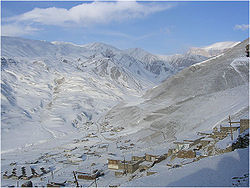
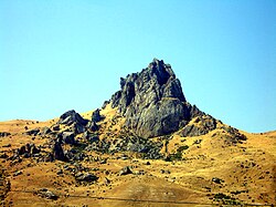
Azerbaijan is home to a vast variety of landscapes. Over half of Azerbaijan's land mass consists of mountain ridges, crests, yailas and plateaus which rise up to hypsometric levels of 400–1,000 meters (including the Middle and Lower lowlands), in some places (Talis, Jeyranchol-Ajinohur and Langabiz-Alat foreranges) up to 100–120 metres, and others from 0 – 50 meters and up (Gobustan, Absheron). The rest of Azerbaijan's terrain consist of plains and lowlands. Hypsometric marks within the Caucasus region vary from about -28 metres at the Caspian Sea shoreline up to 4466 metres at Mount Bazardüzü. [5]

Partial view of the Khudafarin Bridge in Azerbaijan Khoda.jpg
Partial view of the Khudafarin Bridge in Azerbaijan

Geology

The geology of Azerbaijan forms a constituent geological part of the Alpine folded belt. Sedimentary deposits embracing the southwestern parts of the Major and Minor Caucasus, including the intermountain Kur-River trough, as well as the Mid- and South Caspian basins consist of diversity fold systems. The Earth's crust thickness in Azerbaijan varies in the range from 38 to 55 km. Its maximum thickness is observed in the Minor Caucasus area, while its minimum thickness is typical for the Talysh foothills. Geological setting of the area consists of sedimentary, volcanic-sedimentary, volcanic and terrestrial deposits embracing almost entire stratigraphic range beginning from pre-Cambrian period up to Holocene time.

Climate

The climate of Azerbaijan is unique, as nine of the Earth's eleven climate zones are found in Azerbaijan although sitting in the temperate zone. [6]

Temperature, precipitation, humidity, evaporation and cloudiness all influence the landscape and climate of Azerbaijan.

The climate varies considerably from east to west. In the western mountains, the weather is drier and more extreme. The eastern part of Azerbaijan, near the Caspian Sea, has a more moderate climate. As a predominantly mountainous country, Azerbaijan is surrounded by the Greater Caucasus, Lesser Caucasus, Talysh Mountains and North Iranian Mountains.

All these aspects create a unique climate in Azerbaijan.

Flora

Azerbaijan has a rich flora, over 4,500 species of plants have been classified in the country. Due to the unique climate in Azerbaijan, flora is much richer – based on the number of species – than that of other republics of the South Caucasus. About two thirds of all of the species present in the entire Caucasus region can be found in Azerbaijan. [7]

Fauna

Azerbaijan has an amazingly rich and diverse fauna. The first reports of the diversity of animal life in Azerbaijan can be found in travel notes of Eastern travelers. Animal carvings on architectural monuments, ancient rocks and stones survived up to the present times.

There are 106 species of mammals, 97 species of fish, 363 species of birds, 10 species of amphibians and 52 species of reptiles which have been recorded and classified in Azerbaijan.

The natural habitat of various types of animals varies within the country. Some species only populate special restricted areas (lakes, parts of mountainous areas) while others are spread throughout the country. For example, passerines can be found anywhere in the territory of Azerbaijan. Protozoa parasites are also registered in all areas of the country, depending on natural habitat of carrier animals such as cattle and poultry. Among mammals, jeyran gazelles populate plain areas, Caucasian goats inhabit the Major Caucasus areas, most species of birds can be found in forests, some in water basins. Some insects occupy agricultural fields, while others are only present in defined ecosystems.

A number of animal species are protected from hunting within the natural reserves of Azerbaijan.

Karabakh

The symbol of fauna in Azerbaijan is the Karabakh horse which is a mountain-steppe racing and riding horse found only in Azerbaijan. The Karabakh horse is esteemed for its good temper, speed, elegance and intelligence. It is one of the oldest breeds, with ancestry dating to the ancient world. The horse was originally developed in the Karabakh region in the 5th century and is named after it. [8]

Caspian Sea

The Caspian Sea, viewed from Baku, Azerbaijan View of Baku, 2004 (2).jpg
The Caspian Sea, viewed from Baku, Azerbaijan

The Caspian Sea is the largest lake on Earth by both area and volume, with a surface area of 371,000 square kilometres (143,244 mi2) and a volume of 78,200 cubic kilometres (18,761 mi³). It is a landlocked endorheic body of water and lies between Asia and Europe. It has a maximum depth of about 1,025 meters (3,363 feet). It is called a sea because when the Romans discovered it they tasted the water and found it to be salty. It has a salinity of approximately 1.2 percent, about a third the salinity of sea water.

Rivers and lakes

Rivers form the principal part of the water systems of Azerbaijan. There are 8,359 rivers of various lengths within Azerbaijan. Of them 8,188 rivers are less than 25 kilometers in length. Only 24 rivers are over 100 kilometers long.

Environmental issues

Like most republics of the Soviet Union, Azerbaijan experienced rapid development of all spheres of economics and human activity, which led to an all-round negative impact on the environment, including the inefficient usage of natural resources.

See also

Related Research Articles

<span class="mw-page-title-main">Geography of Azerbaijan</span> Overview of the geography of Azerbaijan

Azerbaijan is a country in the Caucasus region, situated at the juncture of Eastern Europe and West Asia. Three physical features dominate Azerbaijan: the Caspian Sea, whose shoreline forms a natural boundary to the east; the Greater Caucasus mountain range to the north; and the extensive flatlands at the country's center. About the size of Portugal or the US state of Maine, Azerbaijan has a total land area of approximately 86,600 km², less than 1% of the land area of the former Soviet Union. Of the three Transcaucasian states, Azerbaijan has the greatest land area. Special administrative subdivisions are the Nakhchivan Autonomous Republic, which is separated from the rest of Azerbaijan by a strip of Armenian territory, and the Nagorno-Karabakh Autonomous Region, entirely within Azerbaijan. The status of Nagorno-Karabakh is disputed by Armenia, but is internationally recognized as territory of Azerbaijan.

Articles related to the Azerbaijan Republic include:

<span class="mw-page-title-main">Fauna of Azerbaijan</span> Native animals of Azerbaijan

Fauna of Azerbaijan or animal kingdom of Azerbaijan refers to the diversity of various types of animals, which inhabit and populate a defined ground or water area in Azerbaijan.

<span class="mw-page-title-main">Orography of Azerbaijan</span>

Orography of Azerbaijan refers to the rocky, mountainous and elevated terrains in Azerbaijan. The tectonic structure is typical for the orography of the country. The main morphostructural units are the Greater Caucasus, the Lesser Caucasus, the Gusar plane, the Samur-Devechi lowland, the Kur intermountain trough, the Karabagh volcanic highland, the near and middle Araz Ridges and Talysh Mountains.

<span class="mw-page-title-main">Flora of Azerbaijan</span> Collective plants of Azerbaijan

Flora of Azerbaijan or Vegetation of Azerbaijan refers to the plants, trees and flowers which can be found in Azerbaijan.

<span class="mw-page-title-main">State reserves of Azerbaijan</span>

State Reserves of Azerbaijan refers to the state reserves in Azerbaijan, which preserve the fauna, flora and their ecosystems.

National parks of Azerbaijan are run by the Ministry of Ecology and Natural Resources in the Republic of Azerbaijan. The first national park established was Zangezur National Park in 2003. Since then a further 9 national parks have been established; the most recent being the Gizilaghaj National Park in 2018.

<span class="mw-page-title-main">Shirvan National Park</span> Azerbaijani national park

Shirvan National Park — is a national park of Azerbaijan. It was established on July 5, 2003 within the territory of Salyan Rayon administrative districts. Its surface area is 54,373.5 hectares (543.735 km2).

<span class="mw-page-title-main">Hirkan National Park</span> National park in Azerbaijan

Hirkan National Park — is a national park of Azerbaijan. It was established in an area in Lankaran Rayon and Astara Rayon administrative districts on February 9, 2004 on the basis of the former "Hirkan State Reserve" which it superseded, on a surface area of 29,760 hectares (297.6 km2). It was enlarged by presidential decree on April 23, 2008 from 29,760 hectares (297.6 km2) to 40,358 hectares (403.58 km2).

Absheron National Park is a national park of Azerbaijan in the Caspian Hyrcanian mixed forests' ecoregion. It was established on 8 February 2005, on an area of 783 hectares (7.83 km2) in the administrative territory of the District of Azizbeyov in the City of Baku, on the base of Absheron State Nature Preserve.

<span class="mw-page-title-main">Göygöl National Park</span> Historic site in Goygol Rayon

Göygöl National Park — is a national park of Azerbaijan. It was established in an area in Goygol Rayon administrative district on April 1, 2008 on the basis of the former "Goy Gol State Reserve" that was established in 1925 and which it superseded, on a surface area of 12,755 hectares (127.55 km2). It was enlarged from 6,739 hectares (67.39 km2) of the former state reserve to its current surface area as a national park.

<span class="mw-page-title-main">Gobustan State Historical and Cultural Reserve</span> National park in Azerbaijan

Gobustan State Historical and Cultural Reserve is located west of the settlement of Gobustan, about 40 miles (64 km) southwest of the centre of Baku. It was established in 1966, when the area was declared a national historical landmark of Azerbaijan in an attempt to preserve the prehistoric rock carvings, mud volcanoes and musical stones in the region.

<span class="mw-page-title-main">Wildlife of Azerbaijan</span>

The wildlife of Azerbaijan consists of its flora and fauna and their natural habitats.

<span class="mw-page-title-main">Absheron Peninsula</span> Peninsula in Azerbaijan

The Absheron Peninsula is a peninsula in Azerbaijan. It is the location of Baku, the biggest and the most populous city of the country, and also the Baku metropolitan area, with its satellite cities Sumqayit and Khyrdalan.

<span class="mw-page-title-main">Tourism in Azerbaijan</span>

Tourism in Azerbaijan has been an important sector of the Azerbaijani economy since the 1990s. According to Azerbaijan's Center for Economic and Social Development, the country is in 39th place among 148 countries in tourism competitiveness indicators. The World Travel and Tourism Council reported that Azerbaijan is among the top ten countries with the greatest increase in visitor exports from 2010 to 2016. The country had the world's fastest-developing travel and tourism economy in 2017. To promote tourism, Azerbaijan sponsored Atlético Madrid jerseys reading "Azerbaijan – Land of Fire". In 2018, a new tourism brand and a slogan "take another look" were introduced.

<span class="mw-page-title-main">Kabardino-Balkaria Nature Reserve</span> Strict nature reserve in Kabardino-Balkaria, Russia

Kabardino-Balkarski Nature Reserve is a Russian 'zapovednik' on main ridge of the north Caucasus Mountains. It contains all of the mountains in Europe over 5,000 meters besides Mt. Elbrus and Mt. Kazbek, and contains the most glaciers. The ridge at the reserve forms the famous "Bezengi wall" consisting of the peaks Gestola, Katyn-Tau, Janga, Eastern Jangi-Tau and Shkhara. There are 256 glaciers in the reserve's boundaries. The reserve is situated in the Chereksky District of Kabardino-Balkar Republic; it was created in 1976, and covers an area of 82,507 ha (318.56 sq mi).

<span class="mw-page-title-main">North Ossetia Nature Reserve</span> Nature reserve in North Ossetia, Russia

North Ossetia Nature Reserve is a Russian 'zapovednik' in the high mountains on the northern slope of the Caucasus Mountains with the heights ranging from 650 meters - 4,249 meters. There are 76 glaciers in the reserve with a total area of 37 km2 (14 sq mi). The site is centered on the Ardon River valley, in the Alagirsky District of North Ossetia-Alania. It was formally created in 1967, and covers a total area of 29,000 ha (110 sq mi).

<span class="mw-page-title-main">Erzi Nature Reserve</span> Nature reserve in Ingushetia, Russia

Erzi Nature Reserve is a Russian 'zapovednik' located on the northern slope of the Greater Caucasus in the Dzheyrahsky Assinsky-basin, adjacent to the Skalisty Range. Rivers in the reserve include the Assa and Armkhi that feed into the Terek River. The northern third of the territory is forested, the ridge area is alpine meadows and mountain steppe. Over 160 historical and cultural sites are also protected by the reserve - martial towers, temples, necropolis tracts, sacred groves, and structures from ancient, medieval and later cultures, many of the Ingush people. The reserve is situated in the Dzheyrakhsky District of Ingushetia.

The Azerbaijan is a country with very favorable natural conditions and rich natural resources. Snowy peaks, high mountains, foothill fertile soils, wide plains, Lowest Land Points Below Ocean Level are the main landscape forms of the republic. This complex landscape structure has resulted in a variety of natural conditions, climate, soil-vegetation, and water resources. This, in turn, led to the uneven distribution of population and farms on the territory, and the specialization of production on different types.

<span class="mw-page-title-main">Gobustan Rock Art</span> UNESCO World Heritage Site

Gobustan Rock Art represents flora and fauna, hunting, lifestyles, and culture of pre-historic and medieval periods of time. The carvings on the rocks illustrates men, ritual dances, men with lances in their hands, animals, bull fights, camel caravans, and pictures of the sun and stars. The date of these carvings goes back to 5,000 – 20,000 years before present.

References

  1. President of Azerbaijan receives award.
  2. Shelton, Napier (2003). "Azerbaijan: Environmental Conditions and Outlook". Ambio. 32 (4): 302–306. doi:10.1579/0044-7447-32.4.302. JSTOR   4315385. PMID   12956597. S2CID   21128113.
  3. Ecological problems in Azerbaijan
  4. Shakhdag to become one of the largest national parks in Europe
  5. Orography of Azerbaijan
  6. "Climates of Azerbaijan". Archived from the original on 2007-01-07. Retrieved 2006-09-21.
  7. "Flora statistics of Azerbaijan". Archived from the original on 2007-09-28. Retrieved 2007-07-16.
  8. Karabakh horse description