Orography of Azerbaijan

Last updated
Besh Barmag Mountain ("Five Finger Mountain") is located in Absheron, Azerbaijan. Mountain Beshbarmag, Azerbaijan, 2007.jpg
Besh Barmag Mountain ("Five Finger Mountain") is located in Absheron, Azerbaijan.

Orography of Azerbaijan refers to the rocky, mountainous and elevated terrains in Azerbaijan. [1] The tectonic structure is typical for the orography of the country. The main morphostructural units are the Greater Caucasus, the Lesser Caucasus, the Gusar plane, the Samur-Devechi lowland, the Kur intermountain trough, the Karabagh volcanic highland, the near and middle Araz Ridges and Talysh Mountains. [2]

Contents

General information

The Candy Cane Mountains near Altiagac Alti Agac.jpg
The Candy Cane Mountains near Altıağac

Azerbaijan is typified by relief of different kinds and complexity. Over 50% of the country's area consists of the mountain ridges, crests, yailas and plateaus rise up to hypsometric levels of 400–1,000 m (including the Middle and Lower lowlands), in some places (Talish, Jeyranchol-Ajinohur and Langabiz-Alat foreranges) up to 100–120 m, as well as 0–50 m up (Gobustan, Absheron) the remaining parts of which are plains and lowlands. Hypsometric marks within the Caucasus region vary in the range from about -28 m at the Caspian Sea shoreline up to 4,466 m at Mount Bazardüzü. [1]

Quantitative distribution

The quantitative area distribution of Azerbaijan according to the hypsometric levels is as follows:

The average elevation is 384 m high. Principle orographic units of Azerbaijan consist of the Caucasus mountain system, Samur-Davachi lowland (in conjunction with Gusar inclined plain), Kur River lowland, Minor Caucasus, and Talish mountain systems. [1]

Caucasus mountains system

The southeast part of the Caucasus mountain region is located within Azerbaijan. The basic orographic elements of this part of the Caucasus system are Major Caucasus system or Watershed Ridge and the Lateral ridge. Major Caucasus ridge constitutes large portion of the Caucasus system and extends southeast off Tinov-Rosso elevation (3,385 m) is located at Azerbaijan border with Georgia and Dagestan. [1]

Major Caucasus

Mountains of Tingalty near Quba Landscape, Quba Rayon, Azerbaijan, summer 2007.jpg
Mountains of Tingalty near Quba

The Major Caucasus or Watershed Ridge is not crossed with any river valleys and therefore it is also called Watershed Ridge. Most part of the ridge elevation is over 3,000 m high, and only in its central part it exceeds 4,000 m height; which are:

Beginning from Babadagh peak (located at 3629m, means "Father Mountain") the same ridge elevation gradually goes down and becomes wider. Starting from Dubrar elevation (2,205 m), Major Caucasus ridge plunges northeastward towards the Caspian Sea like expanded fan having been cut by river valleys into separate ridges like Gadi-Kurkachidagh, Aladagh, Kemchi and others. [1]

Lateral Ridge

The same ridges are further divided into smaller and lower ridges to pass into low elevation mountain region named Gobustan, and further on into Absheron Peninsula. North off and parallel to the Great Caucasus ridge there is a southeast trending ridge called Lateral, of which Azerbaijan section starts from the Shahdagh (located at 4,243 m, means "Kings Mountain") extending and getting lower southeastward and terminates at Beshbarmag (located at 546 m, Besh Barmag Mountain means "Five Finger Mountain") pinnacle. The southeastern section of lateral Ridge Tengi-Beshbarmagh is a medium and low-altitude mountain erosion-denudation relief. The relief of this part consists of the Jurassic and Cretaceous limestone and clay. [2] Lateral ridge is divided into stand-alone blocks-Plateaus (Shahdagh, Gizilgaya, Budugh, and others) by river valleys that begin from Great Caucasus ridge. [1] Northwestern part of the Lateral Ridge matches up to the Shahdagh-Khizi geosyncline constituted of thick Upper Jurassic and Lower Cretaceous dolomite limestone. They create a series of highland plateaus with delimiting covered and steep slopes. [2]

Talabi-Gaynarja elevation

Northeast off and parallel to the Lateral ridge there is Talabi-Gaynarja elevation, which elevation ranges from 1,000–1,100 m in the west down to 150–200 m in the east. Ridges and elevations are divided from each other by valleys and intermontane troughs (Shahnabad, Khinalyg, Erphee, Gonagcand, Kaltan, Gilgilchay, Tigchay, Rustov, Perebedil and others). [1]

The southern flank of the Great Caucasus ridge descended to Alazan-Ayrichay valley (in some sources Alazan-Haftaran valley, whereas in others it is considered one of the Kur River valley parts) that in some places is parallel to the mentioned ridge. Said above valley begins from Georgia and is 210 km long and 30 km wide in Azerbaijan. Nialdagh ridge which elevation reaches up to 2,100 m high is extended parallel to the Great Caucasus one apart through Lahidge valley. [1] They characterized by the middle-altitude mountain denudation relief.

Jeirankechmez depression

The depression is followed by linearly extended folded ridges and dome-shaped elevations substituting with wide synclinal valleys and constitutes in plan to the eastern part of the Shamakhy-Gobustan syncline. The northwestern section of the Jeyrankechmez corresponds to the topography of the Baku age alluvial-proluvial plain. The southeastern part of the depression characterized by younger abrasion-accretion marine plain and relief composed of the large brachyanticline elevations and broken by lengthwise ruptures. Mud volcanoes are typical for there. The depression is limited by the Alyat range and the Langebiz low-altitude mountain range from the south part. This section is consist of Paleogene, Miocene and Pliocene rocks. [2]

Absheron peninsula

The South-Eastern Caucasus ends in the Absheron peninsula and the western part bordering the Dubrar system. Yunusdagh, Ylkhydagh and Koun are the highest parts of the peninsula about 300–350 meters. The topography of the northern area is hummock and hollow. Mud volcanoes are typical for this part and salt lakes are observed, too. There are Akhtarma, Lokbatan, Bozdagh mud volcanoes in the southwest part of the peninsula.

Mud Volcano in Absheron peninsula Mud Volcano, Azerbaijan 7.jpg
Mud Volcano in Absheron peninsula

The eastern part of the Absheron peninsula is flat with a 38-meter maximal height. Bina, Govsan, Tyrkyan and Zirya are below the sea level. Oil and gas-bearing areas are typical for peninsula. [2]

Lesser Caucasus

The Lesser Caucasus Mountain is less high and has a folded-boulder structure caused by the presence of abyssal fractures of transversal and longitudinal striking. The prominent elevations are Murguz, Murovdagh, Shakhdagh, Garabagh, Eastern Goycha, and Mykhtekyan. Shakhdagh ridge consists of volcanic rocks and Upper Cretaceous, Eocene carbonate, and consistent to the same-name syncline. From the northwestern part, Shakhdagh Mountain of the Lesser Caucasus stripes to the southeastern Gilandagh Mountain, and from this part joins Murovdagh. Gyamyshdagh Mountain is the highest point with 3,724 meter height. Northeastern and northern sections of Shakhdagh and Murovdagh Ridge are composed of erosional spurs such as Chyngldagh, Pant, and Kalteke. Shakhdagh, Murovdagh, and Eastern Goycha Ridge are followed by highlands and troughs. The riverside parts characterized by well-preserved peneplanation surfaces of the Early-Middle Miocene Oligocene, Middle Miocene, and Late Pliocene ages.

Eastern Goycha Ridge consists of Eocene, volcanic-sedimentary rocks, and Miopliocene volcanogenic thickness. Ketidagh Mountain is the highest point of the ridge with 3,399 meters in height.

The Garabagh Ridge enlarges in the central part of the Lesser Caucasus southeastern edge. The main peaks of Garabagh are Gyrkhgyz (2,823 m), Boyuk Kirs (2,725 m) and Ziyarat (2,478 m). [2]

Garabagh highland

The Garabagh highland is volcanic oriented and covers the southwestern of the Lesser Caucasus. Late Pliocene, Quaternary and Basaltic andesite lava outflows are typical for the relief of the highland.

Kur-Araz lowland

The lowland is covered by several sites which differ from one another according to their geological structures and orographic features and surrounded by Greater Caucasus and Lesser Caucasus Ridges. In the northern part of the Kur-Araz lowland Ganykh-Airichay synclinal valley extends and in the south of the valley covered by low-rise linearly monoclinic ridges Jeiranchel-Ajinour terrain. Miocene and Upper Pliocene argillo-arenaceous rocks are typical for the relief of terrain. The eastern part of the Jeiranchel-Ajinour terrain covered by rivers and they create antecedent valleys by crossing the low-hill.

The lowland is divided into the Shirvan, Garabagh, Mughan, Mil and Salyan plains by the Kur and Araz river valleys. In the eastern part of the Kur-Araz lowland covered by the Large and Small Kharami, Mishovdagh. Between the southeastern lowland and Caspian seashore alluvial marine plain Shirvan is situated. The Kur-Araz lowland joins to the Lankaran lowland by the Mughan and Salyan plains in the south. Several elevations such as, "gobu", topographic shapes "chala" as well as river-formed lakes called "akhmaz" are typical for the lowland. [2]

Talysh Mountains

Talysh Mountains Talysh mountains.jpg
Talysh Mountains

The Talysh Mountains are considered a continuation of the Lesser Caucasus and followed by Paleogene and Neogene volcanic deposits. Furthermore, the southeastern part of the mountains composed of the Late Cretaceous deposits. Compared with the Greater and Lesser Caucasus glacial landforms are not particular in Talysh Mountains. The prominent ridges in Talysh Mountains are Talysh, Peshtasar, Dizgoni, and Burovar Ridges. The highest point is Kemyurkei Mountain with 2,493 meters situated in Talysh Ridge. Northwest section composed of the middle and upper Miocene deposits.

Between the Caspian Sea and Talysh Mountains is situated the Lankaran depression and the flat lowland seaside is below the sea level. The lowland consists of the river descending sediments. [2]

Related Research Articles

<span class="mw-page-title-main">Geography of Azerbaijan</span> Overview of the geography of Azerbaijan

Azerbaijan is a country in the Caucasus region, situated at the juncture of Europe and Western Asia. Three physical features dominate Azerbaijan: the Caspian Sea, whose shoreline forms a natural boundary to the east; the Greater Caucasus mountain range to the north; and the extensive flatlands at the country's center. About the size of Portugal or the US state of Maine, Azerbaijan has a total land area of approximately 86,600 square kilometers, less than 1% of the land area of the former Soviet Union. Of the three Transcaucasian states, Azerbaijan has the greatest land area. Special administrative subdivisions are the Nakhchivan Autonomous Republic, which is separated from the rest of Azerbaijan by a strip of Armenian territory, and the Nagorno-Karabakh Autonomous Region, entirely within Azerbaijan. The status of Nagorno-Karabakh is disputed by Armenia, but is internationally recognized as territory of Azerbaijan.

<span class="mw-page-title-main">Caucasus Mountains</span> Mountain system at the intersection of Europe, Asia, and the Middle East

The Caucasus Mountains are a mountain range at the intersection of Asia and Europe. Stretching between the Black Sea and the Caspian Sea, they are surrounded by the Caucasus region and are home to Mount Elbrus, the highest peak in Europe at 5,642 metres (18,510 ft) above sea level.

<span class="mw-page-title-main">Gadabay District</span> District of Azerbaijan

Gadabay District is one of the 66 districts of Azerbaijan. It is located in the west of the country and belongs to the Gazakh-Tovuz Economic Region. The district borders the districts of Dashkasan, Shamkir, Tovuz, and the Gegharkunik and Tavush provinces of Armenia. The Artsvashen exclave of Armenia is surrounded by the Gadabay District and is de facto controlled by Azerbaijan, administrated as part of Goranboy District. Its capital and largest city is Gadabay. As of 2020, the district had a population of 109,900.

<span class="mw-page-title-main">Hajigabul District</span> District of Azerbaijan

Hajigabul District is one of the 66 districts of Azerbaijan. It is located in the east of the country and belongs to the Shirvan-Salyan Economic Region. The district borders the districts of Kurdamir, Agsu, Shamakhi, Gobustan, Absheron, Baku, Salyan, Sabirabad and the city of Shirvan. Its capital and largest city is Hajigabul. As of 2020, the district had a population of 76,600.

<span class="mw-page-title-main">Fauna of Azerbaijan</span> Native animals of Azerbaijan

Fauna of Azerbaijan or animal kingdom of Azerbaijan refers to the diversity of various types of animals, which inhabit and populate a defined ground or water area in Azerbaijan.

<span class="mw-page-title-main">Environment of Azerbaijan</span>

The environment of Azerbaijan, includes a wide diversity of climates, animals, plants, and habitats.

<span class="mw-page-title-main">Climate of Azerbaijan</span>

The climate of Azerbaijan is very diverse. Nine out of eleven existing climate zones are present in Azerbaijan.

<span class="mw-page-title-main">Flora of Azerbaijan</span>

Flora of Azerbaijan or Vegetation of Azerbaijan refers to the plants, trees and flowers which can be found in Azerbaijan.

<span class="mw-page-title-main">Bodies of water of Azerbaijan</span>

The water bodies of Azerbaijan were formed over a long geological timeframe and changed significantly throughout that period. This is particularly evidenced by remnants of ancient rivers found throughout the country. The country's water systems are continually changing under the influence of natural forces and human introduced industrial activities. Artificial rivers (canals) and ponds are a part of Azerbaijan's water systems.

National parks of Azerbaijan are run by the Ministry of Ecology and Natural Resources in the Republic of Azerbaijan. The first national park established was Zangezur National Park in 2003. Since then a further 9 national parks have been established; the most recent being the Gizilaghaj National Park in 2018.

Mil plain is a plain in Azerbaijan. It is located on the bank of the Aras river and extends to Iran. Mil-plain is located in the southwest part of the Kur-Araz lowland, where the Kura and Araz rivers meet. The area is between the right bank of the Kura River and the left bank of the Araz River. The north-eastern part of the plain is lower than the ocean level. In the south-west, these areas are covered by sand, gravel. More than 40 percent of the altitude in the plain is 0–100 meters, 25 percent - 100–200 meters above sea level, and 35 percent - absolute altitude is less than 0 meters. The absolute altitude decreases about 8 m to north and varies from 200 to 250 to the west. The plain includes mainly the areas of Imishli and Beylagan districts. Seismic activity is high as the plain is in the convergent border the Alpine-Himalayan orogenic belt.

<span class="mw-page-title-main">Kur-Araz Lowland</span>

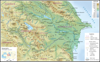
The Kura-Aras Lowland, Kura-Aras Depression or Kura-Aras Basin is a vast depression in central-southern Azerbaijan defined by the valleys of the Kura River and Aras River. It is situated by the West shore of the Caspian Sea and is part of the Aral-Caspian Depression. It is delimited by the Greater Caucasus from the North, Lesser Caucasus from the West and the Talysh Mountains from the South. The name is derived from the names of the two rivers in the area: the Kura and the Aras.

<span class="mw-page-title-main">Geology of Azerbaijan</span>

The geology of Azerbaijan forms a constituent geological part of the Alpine fold belt. Sedimentary deposits embracing the southwestern parts of the Major and Minor Caucasus, including the intermountain Kur River trough, as well as the Mid- and South Caspian basins consist of diversity fold systems. The Earth's crust thickness in Azerbaijan varies in the range from 38 to 55 km. Its maximum thickness is observed in the Minor Caucasus area, while its minimum thickness is typical for the Talysh foothills. The geological setting of the area consists of sedimentary, volcanic-sedimentary, volcanic and terrestrial deposits embracing almost the entire stratigraphic range beginning from Pre-Cambrian through Holocene time.

<span class="mw-page-title-main">Tourism in Azerbaijan</span>

Tourism in Azerbaijan has been an important sector of the Azerbaijani economy since the 1990s. According to Azerbaijan's Center for Economic and Social Development, the country is in 39th place among 148 countries in tourism competitiveness indicators. The World Travel and Tourism Council reported that Azerbaijan is among the top ten countries with the greatest increase in visitor exports from 2010 to 2016. The country had the world's fastest-developing travel and tourism economy in 2017. To promote tourism, Azerbaijan sponsored Atlético Madrid jerseys reading "Azerbaijan – Land of Fire". In 2018, a new tourism brand and a slogan "take another look" were introduced.

<span class="mw-page-title-main">Absheron Economic Region</span> Economic region in Azerbaijan

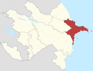
The Absheron Economic Region is located in the eastern part of the Republic of Azerbaijan and comprises Baku and Sumgait cities and the Absheron and Khizi districts. The eastern part of the economic region is located on the shores of the Caspian Sea, which has positive effects on the economy of the region. It borders Shaki-Zaqatala economic region to the north, Mountainous Shirvan to the west and Aran to the south.

<span class="mw-page-title-main">Forests of Azerbaijan</span>

The total forest area of Azerbaijan is 1,021,880 ha or 11.8% of the country's area. The forest biomes consist of temperate deciduous forests, temperate broadleaf and mixed forests, temperate coniferous forests and riparian forests. Specialists estimate that in the 8th-9th centuries the forest cover was around 30-35%, most of it situated in mountainous areas.

The Azerbaijan is a country with very favorable natural conditions and rich natural resources. Snowy peaks, high mountains, foothill fertile soils, wide plains, Lowest Land Points Below Ocean Level are the main landscape forms of republic. This complex landscape structure has caused the variety in natural conditions - climate, soil-vegetation, and water resources. This, in turn, led to the uneven distribution of population and farms on the territory, and the specialization of production on different types.

Mountains of Azerbaijan cover approximately 60 percent of the country's land area. There are three mountain ranges in the territory of Azerbaijan, which are the Greater Caucasus, the Lesser Caucasus, and the Talysh Mountains.

References

  1. 1 2 3 4 5 6 7 8 Азербайджан – Orography Archived 2013-04-18 at the Wayback Machine Azerbaijan.az
  2. 1 2 3 4 5 6 7 8 Akif A. Alizadeh; Ibrahim S. Guliyev; Fakhraddin A. Kadirov; Lev V. Eppelbaum (June 2016). Geosciences of Azerbaijan: Volume I: Geology (Regional Geology Reviews). Springer. ISBN   9783319273938.