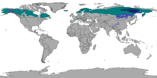
The subarctic climate is a continental climate with long, cold winters, and short, warm to cool summers. It is found on large landmasses, often away from the moderating effects of an ocean, generally at latitudes from 50°N to 70°N, poleward of the humid continental climates. Like other Class D climates, they are rare in the Southern Hemisphere, only found at some isolated highland elevations. Subarctic or boreal climates are the source regions for the cold air that affects temperate latitudes to the south in winter. These climates represent Köppen climate classification Dfc, Dwc, Dsc, Dfd, Dwd and Dsd.

The desert climate or arid climate is a dry climate sub-type in which there is a severe excess of evaporation over precipitation. The typically bald, rocky, or sandy surfaces in desert climates are dry and hold little moisture, quickly evaporating the already little rainfall they receive. Covering 14.2% of Earth's land area, hot deserts are the second most common type of climate on Earth after the polar climate.

A Mediterranean climate, also called a dry summer climate, described by Köppen as Cs, is a temperate climate type that occurs in the lower mid-latitudes. Such climates typically have dry summers and wet winters, with summer conditions being hot and winter conditions typically being mild. These weather conditions are typically experienced in the majority of Mediterranean-climate regions and countries, but remain highly dependent on proximity to the ocean, altitude and geographical location.

Tropical climate is the first of the five major climate groups in the Köppen climate classification identified with the letter A. Tropical climates are defined by a monthly average temperature of 18 °C (64 °F) or higher in the coolest month, featuring hot temperatures and high humidity all year-round. Annual precipitation is often abundant in tropical climates, and shows a seasonal rhythm but may have seasonal dryness to varying degrees. There are normally only two seasons in tropical climates, a wet (rainy/monsoon) season and a dry season. The annual temperature range in tropical climates is normally very small. Sunlight is intense in these climates.
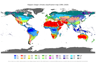
The Köppen climate classification is one of the most widely used climate classification systems. It was first published by German-Russian climatologist Wladimir Köppen (1846–1940) in 1884, with several later modifications by Köppen, notably in 1918 and 1936. Later, German climatologist Rudolf Geiger (1894–1981) introduced some changes to the classification system in 1954 and 1961, which is thus sometimes called the Köppen–Geiger climate classification.

An oceanic climate, also known as a marine climate or maritime climate, is the temperate climate sub-type in Köppen classification represented as Cfb, typical of west coasts in higher middle latitudes of continents, generally featuring cool to warm summers and cool to mild winters, with a relatively narrow annual temperature range and few extremes of temperature. Oceanic climates can be found in both hemispheres generally between 40 and 60 degrees latitude, with subpolar versions extending to 70 degrees latitude in some coastal areas. Other varieties of climates usually classified together with these include subtropical highland climates, represented as Cwb or Cfb, and subpolar oceanic or cold subtropical highland climates, represented as Cfc or Cwc. Subtropical highland climates occur in some mountainous parts of the subtropics or tropics, some of which have monsoon influence, while their cold variants and subpolar oceanic climates occur near polar or tundra regions.

The climate of India consists of a wide range of weather conditions across a vast geographic scale and varied topography. Based on the Köppen system, India encompasses a diverse array of climatic subtypes. These range from arid and semi-arid regions in the west to highland, sub-arctic, tundra, and ice cap climates in the northern Himalayan regions, varying with elevation. The northern lowlands experience subtropical conditions, with some areas at higher altitudes, like Srinagar, touching continental climates. In contrast, much of the south and the east exhibit tropical climate conditions, which support lush rainforests in these territories. Many regions have starkly different microclimates, making it one of the most climatically diverse countries in the world. The country's meteorological department follows the international standard of four seasons with some local adjustments: winter, summer, monsoon or rainy season, and a post-monsoon period.

The Khoja are a mainly Shia tribe of people of the western Indian subcontinent. They are historically members of the Bania caste.

A humid continental climate is a climatic region defined by Russo-German climatologist Wladimir Köppen in 1900, typified by four distinct seasons and large seasonal temperature differences, with warm to hot summers, and cold and snowy winters. Precipitation is usually distributed throughout the year, but often these regions do have dry seasons. The definition of this climate in terms of temperature is as follows: the mean temperature of the coldest month must be below 0 °C (32.0 °F) or −3 °C (26.6 °F) depending on the isotherm, and there must be at least four months whose mean temperatures are at or above 10 °C (50 °F). In addition, the location in question must not be semi-arid or arid. The cooler Dfb, Dwb, and Dsb subtypes are also known as hemiboreal climates. Although amount of snowfall is not a factor used in defining the humid continental climate, snow during the winter in this type of climate is almost a guarantee, either intermittently throughout the winter months near the poleward or coastal margins, or persistently throughout the winter months elsewhere in the climate zone.
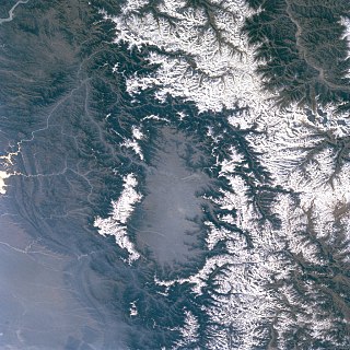
The Kashmir Valley, also known as the Vale of Kashmir, is an intermontane valley in northern Jammu and Kashmir, a region in the disputed Indian-administered Kashmir. The valley is surrounded by ranges of the Himalayas, bounded on the southwest by the Pir Panjal Range and on the northeast by the Greater Himalayan range. It is approximately 135 km (84 mi) long and 32 km (20 mi) wide, and drained by the Jhelum River. It forms the bulk of the Kashmir Division of Jammu and Kashmir.
Pir Sadardin, also known as Pir Sadrudin or Pīr Ṣadr al-Dīn, was a fourteenth-century Shia Ismaili Da'i who founded the Satpanth Tariqa and taught tolerance, perennialism and syncretism of all religions, putting a particular emphasis on the syncretism of Islam and Hinduism.
Ginans are devotional hymns or poems recited by Shia Ismaili Muslims.
Satpanth is a Sanskrit term, given to a diverse group of individuals who follow Pir Sadardin. Pir Sadardin Imamshah Bawa, was a Shia Ismaili Da'i who founded the Satpanth Tariqa around 600 years ago, and taught tolerance, perennialism and syncretism of all religions, putting a particular emphasis on the syncretism of Islam and Hinduism.

Bāṭin or baten literally means "inner", "inward", "hidden", etc. The Quran, for instance, has a hidden meaning in contrast to its exterior or apparent meaning, the zahir (zaher). Sufis believe that every individual has a batin in the world of souls. It is the inward self of the individual; when cleansed with the light of one's spiritual guide, it elevates a person spiritually. This notion is connected to Allah's attribute of the Hidden One, who cannot be seen but exists in every realm.

Tropical savanna climate or tropical wet and dry climate is a tropical climate sub-type that corresponds to the Köppen climate classification categories Aw and As. The driest month has less than 60 mm (2.4 in) of precipitation and also less than mm of precipitation.

Most regions of Japan, such as Honshu, Shikoku, and Kyushu, belong to the temperate zone with humid subtropical climate characterized by four distinct seasons. However, its climate varies from cold humid continental climate in the north such as northern Hokkaido, to warm tropical rainforest climate in the south such as the Yaeyama Islands and Minami-Tori-shima.

Vietnam has a monsoon-influenced climate typical of that of mainland Southeast Asia. The diverse topography, long latitude, and influences from the South China Sea lead to climatic conditions varying significantly between regions. The northern region experiences a monsoonal and temperate climate (Cfa) with four distinct seasons with winters typically dry and summers ranging from hot to mild. In southern and central areas, the climate is tropical monsoon (Aw) with only two seasons. In addition, a temperate climate exists in mountainous areas, which are found in Sa Pa and Da Lat, while a more continental climate exists in Lai Châu Province and Sơn La Province.

A humid subtropical climate is a temperate climate type characterized by hot and humid summers, and cool to mild winters. These climates normally lie on the southeast side of all continents, generally between latitudes 25° and 40° and are located poleward from adjacent tropical climates, and equatorward from either humid continental or oceanic climates. It is also known as warm temperate climate in some climate classifications.

An area of tropical monsoon climate is a tropical climate subtype that corresponds to the Köppen climate classification category Am. Tropical monsoon climates have monthly mean temperatures above 18 °C (64 °F) in every month of the year and a dry season. The tropical monsoon climate is the intermediate climate between the wet Af and the drier Aw.
Seoul, the capital of South Korea, features a dry-winter humid continental climate (Dwa) in the 0°C isotherm according to the Köppen climate classification. If the -3°C isotherm is used, the climate is a dry-winter humid subtropical climate (Cwa) and there are four highly distinct seasons. In summer the influence of the North Pacific high-pressure system brings hot, humid weather with temperatures soaring as high as 35 °C (95 °F) on occasion. In winter the city is topographically influenced by expanding Siberian High-pressure zones and prevailing west winds bring colder air to Korea. The bitterly cold days are commonly known to come in three-day cycles regulated by rising and falling pressure systems. The most pleasant seasons for most people in the city are spring and autumn, when azure skies and comfortable temperatures are typical. Most of Seoul's precipitation falls in the summer monsoon period between June and September, as a part of East Asian monsoon season.


