
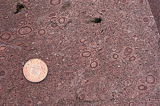
Greensand or green sand is a sand or sandstone which has a greenish color. This term is specifically applied to shallow marine sediment that contains noticeable quantities of rounded greenish grains. These grains are called glauconies and consist of a mixture of mixed-layer clay minerals, such as smectite and glauconite mica. Greensand is also loosely applied to any glauconitic sediment.

Lake Nipigon is part of the Great Lake drainage basin. It is the largest lake entirely within the boundaries of the Canadian province of Ontario.
The Keuper is a lithostratigraphic unit in the subsurface of large parts of west and central Europe. The Keuper consists of dolomite, shales or claystones and evaporites that were deposited during the Middle and Late Triassic epochs. The Keuper lies on top of the Muschelkalk and under the predominantly Lower Jurassic Lias or other Early Jurassic strata.

The Purbeck Group is an Upper Jurassic to Lower Cretaceous lithostratigraphic group in south-east England. The name is derived from the district known as the Isle of Purbeck in Dorset where the strata are exposed in the cliffs west of Swanage.

Ampato is a dormant 6,288-metre (20,630 ft) stratovolcano in the Andes of southern Peru. It lies about 70–75 kilometres (43–47 mi) northwest of Arequipa and is part of a north-south chain that includes the volcanoes Hualca Hualca and Sabancaya, the last of which has been active in historical time.
The Stac Fada Member is a distinctive layer towards the top of the Mesoproterozoic Bay of Stoer Formation, part of the Stoer Group in northwest Scotland. This rock unit is generally 10 to 15 metres thick and is made of sandstone that contains accretionary lapilli and many dark green glassy fragments of mafic composition.
The Debolt Formation is a stratigraphical unit of Meramecian age in the Western Canadian Sedimentary Basin.
The Exshaw Formation is a stratigraphic unit in the Western Canada Sedimentary Basin. It takes the name from the hamlet of Exshaw, Alberta in the Canadian Rockies, and was first described from outcrops on the banks of Jura Creek north of Exshaw by P.S. Warren in 1937. The formation is of Late Devonian to Early Mississippian age as determined by conodont biostratigraphy, and it straddles the Devonian-Carboniferous boundary.
The Clarence Moreton Basin is a Mesozoic sedimentary basin on the easternmost part of the Australian continent. It is located in the far north east of the state of New South Wales around Lismore and Grafton and in the south east corner of Queensland. It is the part of the Great Artesian Basin that extends to the east coast in Australia's central eastern lowlands.
Calabozos is a Holocene caldera in central Chile's Maule Region. Part of the Chilean Andes' volcanic segment, it is considered a member of the Southern Volcanic Zone (SVZ), one of the three distinct volcanic belts of South America. This most active section of the Andes runs along central Chile's western edge, and includes more than 70 of Chile's stratovolcanoes and volcanic fields. Calabozos lies in an extremely remote area of poorly glaciated mountains.
The Ellisras Basin is a geological basin that spans the border between South Africa and Botswana, extending west from the town of Lephalale in Limpopo province. Basin fill consists of sedimentary rocks of the Karoo Supergroup, with maximum thickness of 1,500 metres (4,900 ft).

The Bass Formation, also known as the Bass Limestone, is a Mesoproterozoic rock formation that outcrops in the eastern Grand Canyon, Coconino County, Arizona. The Bass Formation erodes as either cliffs or stair-stepped cliffs. In the case of the stair-stepped topography, resistant dolomite layers form risers and argillite layers form steep treads. In general, the Bass Formation in the Grand Canyon region and associated strata of the Unkar Group-rocks dip northeast (10°–30°) toward normal faults that dip 60+° toward the southwest. This can be seen at the Palisades fault in the eastern part of the main Unkar Group outcrop area. In addition, thick, prominent, and dark-colored basaltic sills intrude across the Bass Formation.
Sliabh an Iarainn, anglicized Slieve Anierin, is a mountain in County Leitrim, Ireland. It rises to 585 metres (1,919 ft) and lies east of Lough Allen and northeast of Drumshanbo. Its present form evolved from the southwestward movement of ice age glaciers over millions of years, the morainic drift heaping thousands of drumlins in the surrounding lowlands. Historically there were many iron ore deposits and ironworks in the area. Irish mythology associates the mountain with the Tuatha Dé Danann, particularly the smith god Goibniu. Sliabh an Iarainn is an important natural heritage site with exposed marine and coastal fauna of paleontological interest
The Kapp Toscana Group is a geologic group in Svalbard and Jan Mayen in the Barents Sea, Norway.
The Prairie Evaporite Formation, also known as the Prairie Formation, is a geologic formation of Middle Devonian (Givetian) age that consists primarily of halite and other evaporite minerals. It is present beneath the plains of northern and eastern Alberta, southern Saskatchewan and southwestern Manitoba in Canada, and it extends into northwestern North Dakota and northeastern Montana in the United States.
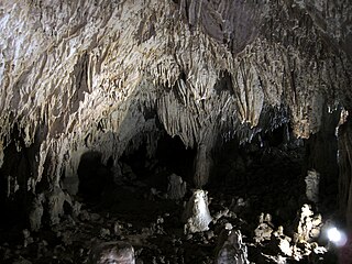
The Romito cave is a natural limestone cave in the Lao Valley of Pollino National Park, near the town of Papasidero in Calabria, Italy. Stratigraphic record of the first excavation confirmed prolonged paleo-human occupation during the Upper Paleolithic since 17,000 years ago and the Neolithic since 6,400 years ago. A single, but exquisite piece of Upper Paleolithic parietal rock engraving was documented. Several burial sites of varying age were initially discovered. Irregularly recurring sessions have led to additional finds, which suggests future excavation work. Notable is the amount of accumulated data that has revealed deeper understanding of prehistoric daily life, the remarkable quality of the rock carvings and the burial named Romito 2, who exhibits features of pathological skeletal conditions (dwarfism).

The geology of Lebanon remains poorly studied prior to the Jurassic. The country is heavily dominated by limestone, sandstone, other sedimentary rocks, and basalt, defined by its tectonic history. In Lebanon, 70% of exposed rocks are limestone karst.

The geology of the Republic of the Congo, also known as Congo-Brazzaville, to differentiate from the Democratic Republic of the Congo, formerly Zaire, includes extensive igneous and metamorphic basement rock, some up to two billion years old and sedimentary rocks formed within the past 250 million years. Much of the country's geology is hidden by sediments formed in the past 2.5 million years of the Quaternary.

The Gai-As Formation is an Early to Middle Permian geologic formation correlated with the Ecca Group and designated "Ecca" Group, because it does not belong to the Karoo, in the southwestern Kunene Region and northern Erongo Region of northwestern Namibia. The Gai-As Formation represents the second-oldest sedimentary unit of the Huab Basin, overlying the Huab Formation. The formation was deposited in a fluvial to lacustrine setting.

The geology of Uzbekistan consists of two microcontinents and the remnants of oceanic crust, which fused together into a tectonically complex but resource rich land mass during the Paleozoic, before becoming draped in thick, primarily marine sedimentary units.