Restoule River

Last updated
Restoule River
Restoule River.jpeg
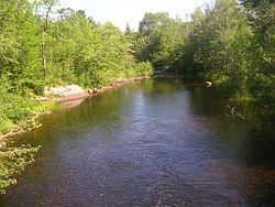
Restoule River looking north from Hawthorne Drive in the community of Restoule
Canada Ontario relief location map.jpg
Red pog.svg
Location of the mouth of the Restoule River in Ontario
Location
Country Canada
Province Ontario
Region Central Ontario
District Parry Sound
Physical characteristics
Source Commanda Lake
  location Restoule, Patterson Township
  coordinates 46°01′36″N79°43′12″W / 46.02667°N 79.72000°W / 46.02667; -79.72000
  elevation222 m (728 ft)
Mouth French River
  location
Hardy Township
  coordinates
46°06′29″N80°01′03″W / 46.10806°N 80.01750°W / 46.10806; -80.01750 Coordinates: 46°06′29″N80°01′03″W / 46.10806°N 80.01750°W / 46.10806; -80.01750
  elevation
187 m (614 ft)
Length40 km (25 mi)
Basin features
River system Lake Huron drainage basin

The Restoule River is a river in Parry Sound District in Central Ontario, Canada. [1] It rises at Commanda Lake in geographic Patterson Township [2] at the community of Restoule. It then flows north into Restoule Lake then north into Stormy Lake at Restoule Provincial Park, at the end of Ontario Highway 534. It then heads west into geographic Hardy Township [3] to its mouth at the French River.

Contents

The total length of the river is about 40 kilometres (20 mi). From Lennon Lake in Hardy Township to the mouth, the river forms a boundary of the Dokis 9 First Nations reserve. [3]

Tributaries

See also

Related Research Articles

Restoule Designated place with Local Services Board in Ontario, Canada

Restoule is a community and designated place in geographic Patterson Township in the Centre Unorganized Part of Parry Sound District in Central Ontario, Canada. It is situated on the Restoule River between Commanda Lake, and Restoule Lake and is part of the Almaguin Highlands region.

Restoule Provincial Park

Restoule Provincial Park is a provincial park in Parry Sound District in Central Ontario, Canada. It is located between Restoule Lake and Stormy Lake and extends along the banks of the Restoule River to its mouth at the French River in geographic Patterson Township and geographic Hardy Township. The park is located at the western terminus of Highway 534 northwest of Restoule, Ontario. The park offers three hiking trails and is home to coyotes, wolves, bears, otters, pine martens, moose and one of Ontario's largest white-tailed deer herd. It is also home to over 90 species of birds including the peregrine falcon, and the heron. The camping sites include Bells Point, Putts Point and Kettle Point. Many hike the well-marked trail to the 100-foot (30 m) fire tower overlooking Stormy Lake. It is one of two provincial parks found in the Almaguin Highlands.

Bobs Lake is a lake in Frontenac County and Lanark County in Eastern Ontario, Canada. It is in the St. Lawrence River drainage basin and is the source of the Tay River.

The Wolf River is a river in Parry Sound District in Central Ontario, Canada. It is in the Great Lakes Basin and is a right tributary of the Pickerel River.

Black River (Hastings County)

The Black River is a river in Hastings County in Central Ontario, Canada. It is part of the Great Lakes Basin, and is a left tributary of the Moira River.

The Black River is a river in Thunder Bay District in Northwestern Ontario, Canada. It is part of the Great Lakes Basin, and is a left tributary of the Pic River.

Depot Creek is a river in Sudbury District in Northeastern Ontario, Canada, near the community of Cartier. It is in the Great Lakes Basin and is a left tributary of Carhess Creek.

Carhess Creek is a river in Greater Sudbury and Sudbury District in Northeastern Ontario, Canada. It is in the Great Lakes Basin and is a right tributary of the Onaping River. The name is a portmanteau of the names of two geographic townships through which it flows, Hess Township and Cartier Township.

Onaping River

The Onaping River is a river in Greater Sudbury and Sudbury District in Northeastern Ontario, Canada. It is in the Great Lakes Basin and is a right tributary of the Vermilion River.

The Matawin River is a river in Thunder Bay District in Northwestern Ontario, Canada. It is in the Great Lakes Basin and is a right tributary of the Kaministiquia River.

The Dunrankin River is a river in Algoma District and Sudbury District in northeastern Ontario, Canada. It is in the James Bay drainage basin, begins at Upper Dunrankin Lake and is a left tributary of the Kapuskasing River.

The Nemegosenda River is a river in Algoma District and Sudbury District in northeastern Ontario, Canada. It is in the James Bay drainage basin, and is a right tributary of the Kapuskasing River.

The Borden River is a river in Sudbury District in northeastern Ontario, Canada. It is in the James Bay drainage basin, and is a left tributary of the Nemegosenda River.

The Shawmere River is a river in Sudbury District in northeastern Ontario, Canada. It is in the James Bay drainage basin, and is a left tributary of the Ivanhoe River.

The Greenhill River is a river in Algoma District in northeastern Ontario, Canada. It is in the James Bay drainage basin, and is a left tributary of the Missinaibi River.

The South Greenhill River is a river in Algoma District and Sudbury District in northeastern Ontario, Canada. It is in the James Bay drainage basin, and is a right tributary of the Greenhill River.

The Fire River is a river in Algoma District in northeastern Ontario, Canada. It is in the James Bay drainage basin, and is a left tributary of the Missinaibi River.

Woollings Creek is a creek in Timiskaming District and Cochrane District in northeastern Ontario, Canada. It is in the James Bay drainage basin and is a tributary of the Whiteclay River.

The Jocko River is a river in Nipissing District in Northeastern Ontario, Canada. It is in the Saint Lawrence River drainage basin, is a right tributary of the Ottawa River, and lies entirely within Jocko Rivers Provincial Park.

Grindstone Creek is a stream in the Unorganized North Part of Algoma District in Northeastern Ontario, Canada. It is in the Great Lakes Basin and is a left tributary of the Mississagi River.

References

  1. "Restoule River". Geographical Names Data Base . Natural Resources Canada . Retrieved 2013-06-11.
  2. "Patterson" (PDF). Geology Ontario - Historic Claim Maps. Ontario Ministry of Northern Development, Mines and Forestry . Retrieved 2013-06-11.[ permanent dead link ]
  3. 1 2 "Hardy" (PDF). Geology Ontario - Historic Claim Maps. Ontario Ministry of Northern Development, Mines and Forestry. Archived from the original (PDF) on 2016-03-04. Retrieved 2013-06-11.

Sources