Return Creek

Last updated
Return Creek
Country United States
State California
Source Sierra Nevada
 - elevation 11,938 ft (3,639 m)
 - coordinates 38°04′51″N119°21′18″W / 38.08083°N 119.35500°W / 38.08083; -119.35500   [1]
Mouth Tuolumne River
 - elevation 6,204 ft (1,891 m)
 - coordinates 37°55′55″N119°27′58″W / 37.93194°N 119.46611°W / 37.93194; -119.46611 Coordinates: 37°55′55″N119°27′58″W / 37.93194°N 119.46611°W / 37.93194; -119.46611   [1]
Length 12.96 mi (21 km)
Relief map of California.png
Red pog.svg
Location of Return Creek in California

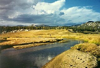
Return Creek is a stream in the northeast part of Yosemite National Park, in Tuolumne County, California, and is a tributary of the Tuolumne River. About 13 miles (21 km) in length, it is the first major tributary to join downstream of Tuolumne Meadows. The creek begins at Return Lake on the Sierra Crest, near Virginia Pass, and flows initially east before turning southwest and joining with McCabe Creek and Spiller Creek. On its path to the Tuolumne River the creek has carved out the 2,000-foot (610 m) deep Virginia Canyon, which was enlarged to its present shape by glaciation. After its confluence with Matterhorn Creek it flows south-southwest to its confluence with the Tuolumne River, about a quarter mile (400 m) below Waterwheel Falls. [2]

Yosemite National Park National park in California, United States

Yosemite National Park is an American national park located in the western Sierra Nevada of Central California, bounded on the southeast by Sierra National Forest and on the northwest by Stanislaus National Forest. The park is managed by the National Park Service and covers an area of 747,956 acres and sits in four counties: centered in Tuolumne and Mariposa, extending north and east to Mono and south to Madera County. Designated a World Heritage site in 1984, Yosemite is internationally recognized for its granite cliffs, waterfalls, clear streams, giant sequoia groves, lakes, mountains, meadows, glaciers, and biological diversity. Almost 95% of the park is designated wilderness.

California State of the United States of America

California is a state in the Pacific Region of the United States. With 39.6 million residents, California is the most populous U.S. state and the third-largest by area. The state capital is Sacramento. The Greater Los Angeles Area and the San Francisco Bay Area are the nation's second- and fifth-most populous urban regions, with 18.7 million and 9.7 million residents respectively. Los Angeles is California's most populous city, and the country's second-most populous, after New York City. California also has the nation's most populous county, Los Angeles County, and its largest county by area, San Bernardino County. The City and County of San Francisco is both the country's second-most densely populated major city after New York City and the fifth-most densely populated county, behind only four of the five New York City boroughs.

Tuolumne River watercourse in the United States of America

The Tuolumne River flows for 149 miles (240 km) through Central California, from the high Sierra Nevada to join the San Joaquin River in the Central Valley. Originating at over 8,000 feet (2,400 m) above sea level in Yosemite National Park, the Tuolumne drains a rugged watershed of 1,958 square miles (5,070 km2), carving a series of canyons through the western slope of the Sierra. While the upper Tuolumne is a fast-flowing mountain stream, the lower river crosses a broad, fertile and extensively cultivated alluvial plain. Like most other central California rivers, the Tuolumne is dammed multiple times for irrigation and the generation of hydroelectricity.

The Pacific Crest Trail follows part of Virginia Canyon and crosses Return Creek just above the confluence of McCabe Creek. [3]

Pacific Crest Trail long-distance hiking and equestrian trail in the USA

The Pacific Crest Trail, officially designated as the Pacific Crest National Scenic Trail (PCT) is a long-distance hiking and equestrian trail closely aligned with the highest portion of the Sierra Nevada and Cascade mountain ranges, which lie 100 to 150 miles east of the U.S. Pacific coast. The trail's southern terminus is on the U.S. border with Mexico, just south of Campo, California, and its northern terminus on the Canada–US border on the edge of Manning Park in British Columbia; its corridor through the U.S. is in the states of California, Oregon, and Washington.

Return Creek has also been labeled, on early maps, as the North Fork of the Tuolumne River. [1] This is not to be confused with the actual North Fork Tuolumne River, located much further to the west.

North Fork Tuolumne River

The North Fork Tuolumne River is a 35.7-mile (57.5 km) long river in the central Sierra Nevada of Tuolumne County, California and is a major tributary of the Tuolumne River. It originates above the Dodge Ridge Ski Area about 2 miles (3.2 km) east of Pinecrest, in the Stanislaus National Forest. From there it flows generally southwest, past Long Barn, Twaine Harte, Soulsbyville and Tuolumne. Below Long Barn the river flows through a narrow canyon on its way to join the Tuolumne River, at the head of Lake Don Pedro Reservoir, about 5 miles (8.0 km) north of Groveland.

Related Research Articles

Merced River body of water in California

The Merced River, in the central part of the U.S. state of California, is a 145-mile (233 km)-long tributary of the San Joaquin River flowing from the Sierra Nevada into the San Joaquin Valley. It is most well known for its swift and steep course through the southern part of Yosemite National Park, where it is the primary watercourse flowing through Yosemite Valley. The river's character changes dramatically once it reaches the plains of the agricultural San Joaquin Valley, where it becomes a slow-moving meandering stream.

Clavey River river in the United States of America

The Clavey River is a tributary of the Tuolumne River in the Sierra Nevada, located in the Stanislaus National Forest and Tuolumne County, California. The river is 31.3 miles (50.4 km) long, and is one of the few undammed rivers on the western slope of the Sierra. Via the Tuolumne River, the Clavey is part of the San Joaquin River watershed.

Cosumnes River river in the United States of America

The Cosumnes River is a river in northern California in the United States. It rises on the western slope of the Sierra Nevada and flows approximately 52.5 miles (84.5 km) into the Central Valley, emptying into the Mokelumne River in the Sacramento-San Joaquin Delta.

Cherry Creek (Tuolumne River tributary)

Cherry Creek is a large, swift-flowing stream in the Sierra Nevada mountain range, and is the largest tributary of the Tuolumne River. The creek is 40 miles (64 km) long measured to its farthest headwaters; the main stem itself is 26 miles (42 km) long, draining a watershed of 234 square miles (610 km2) in the Stanislaus National Forest. Part of the drainage also extends into the northwest corner of Yosemite National Park.

South Fork Kern River river in the United States of America

The South Fork Kern River is a tributary of the Kern River in the Sierra Nevada of the U.S. state of California. It is one of the southernmost rivers on the western slope of the mountains, and drains a high, relatively dry plateau country of 982 square miles (2,540 km2) along the Sierra Crest. The upper South Fork flows through a series of rugged canyons, but it also drains a flat, marshy valley before joining the Kern River at Lake Isabella.

Falls Creek (California) river in the United States of America

Falls Creek, also known as the Falls River, is a tributary of the Tuolumne River in Yosemite National Park, California, United States. The creek begins at the northern boundary of the national park and flows 24 miles (39 km) to empty into the Tuolumne at Hetch Hetchy Reservoir, dropping over two well-known waterfalls. The Pacific Crest Trail and other national park trails follow the creek for much of its course.

South Fork Merced River river in the United States of America

The South Fork Merced River is the largest tributary of the Merced River. Most of the river flows within Yosemite National Park in the Sierra Nevada of California. The river is 43 miles (69 km) long, and its drainage basin covers about 240 square miles (620 km2), of which 109 square miles (280 km2) are in the national park. The average flow at the mouth is 356 cubic feet per second (10.1 m3/s).

North Fork American River river in the United States of America

The North Fork American River is the longest branch of the American River in Northern California. It is 88 miles (142 km) long from its source at the crest of the Sierra Nevada, near Lake Tahoe, to its mouth at Folsom Lake northeast of Sacramento. Prior to the construction of Folsom Dam the river was about 9 miles (14 km) longer making for a total length of 97 miles (156 km).

North Fork Payette River river in the United States of America

The North Fork Payette River is a river in western Idaho in the United States. It stretches over 113 miles (182 km) from north to south, flowing from the Salmon River Mountains to near Banks, where it joins with the South Fork Payette River to form the Payette River, a tributary of the Snake River. Its watershed comprises more than 900 square miles (2,300 km2) of forested mountains and sprawling lakes and wetlands.

Middle Fork Kings River river in the United States of America

The Middle Fork Kings River is a 37.2-mile (59.9 km) tributary of the Kings River in Kings Canyon National Park, California, in the southern Sierra Nevada. Draining 318 square miles (820 km2) – almost all of it wilderness – the Middle Fork is one of the largest wholly undeveloped watersheds in the state, with no dams or paved roads within its basin. The entire length of the Middle Fork is designated a National Wild and Scenic River.

South Fork Kings River river in the United States of America

The South Fork Kings River is a 44.1-mile (71.0 km) tributary of the Kings River in the Sierra Nevada of Fresno County, California. The river forms part of Kings Canyon, the namesake of Kings Canyon National Park and one of the deepest canyons in North America with a maximum relief of 8,200 feet (2,500 m) from rim to river.

North Fork Stanislaus River river in eastern California, USA

The North Fork Stanislaus River is a 31.2-mile (50.2 km) tributary of the Stanislaus River in the central Sierra Nevada and Stanislaus National Forest of eastern California.

Middle Fork Stanislaus River river in the United States of America

The Middle Fork Stanislaus River is a 45.7-mile (73.5 km) tributary of the Stanislaus River in the central Sierra Nevada and Stanislaus National Forest of eastern California.

Piute Creek (Tuolumne River tributary)

Piute Creek is a 19-mile (31 km) long stream in northern Yosemite National Park, in Tuolumne County, California. It is a major tributary of the Tuolumne River, draining a rugged and remote area of the Sierra Nevada.

Rancheria Creek

Rancheria Creek is a 22-mile (35 km) long stream in northern Yosemite National Park mostly in Tuolumne County, California and is a tributary of the Tuolumne River. Draining a large area of the Sierra Nevada, it is the largest tributary of the Tuolumne within Yosemite National Park. The stream is labeled as Kerrick Creek on some early maps.

South Fork San Joaquin River

The South Fork San Joaquin River is the largest headwater of the San Joaquin River in central California, United States. About 48 miles (77 km) long, it drains an area of the high Sierra Nevada about 60 miles (97 km) northeast of Fresno.

Willow Creek (Grand and Uintah counties, Utah) river in Grand and Uintah counties in Utah, Untied States

Willow Creek is a major north-flowing stream in Utah, United States, and is a tributary of the Green River. The creek drains a large remote area of the East Tavaputs Plateau, flowing into the Green River south of Ouray.

Bubbs Creek

Bubbs Creek is a 16.4-mile (26.4 km)-long tributary of the South Fork Kings River in the Sierra Nevada of California, within Kings Canyon National Park.

References

  1. 1 2 3 "Return Creek". Geographic Names Information System . United States Geological Survey. 1981-01-19. Retrieved 2017-01-15.
  2. USGS Topo Maps for United States (Map). Cartography by United States Geological Survey. ACME Mapper. Retrieved 2017-01-15.
  3. Yosemite National Park (PDF) (Map). Cartography by National Park Service. U.S. National Park Service. 2003. Retrieved 2017-01-15.