Related Research Articles
The Ohio Range is a mountain range in the Transantarctic Mountains of Antarctica. It is about 48 km (30 mi) long and 16 km (10 mi) wide, extending WSW-ENE from Eldridge Peak to Mirsky Ledge. The range forms the northeast end of the Horlick Mountains and consists primarily of a large snow-topped plateau with steep northern cliffs and several flat-topped ridges and mountains. The highest point is the summit of Mount Schopf.

The Dater Glacier is a steep valley glacier in Antarctica, 24 nautical miles long and from 1 to 3 nautical miles wide, flowing northeast in a sinuous course from the eastern slopes of the Vinson Massif between Sullivan Heights and Veregava Ridge to Rutford Ice Stream which borders the eastern flank of the Sentinel Range, Ellsworth Mountains. At the lower end the Dater Glacier coalesces with the terminus of the Ellen Glacier, the two emerging from the Sentinel Range as one stream just north of the Flowers Hills.

The Prince Charles Mountains are a major group of mountains in Mac. Robertson Land in Antarctica, including the Athos Range, the Porthos Range, and the Aramis Range. The highest peak is Mount Menzies, with a height of 3,228 m (10,591 ft). Other prominent peaks are Mount Izabelle and Mount Stinear. These mountains, together with other scattered peaks, form an arc about 420 km (260 mi) long, extending from the vicinity of Mount Starlight in the north to Goodspeed Nunataks in the south.
El-Sayed Glacier is a glacier about 15 nautical miles long which drains the northeast slopes of Zuncich Hill in Marie Byrd Land. It flows northeast to enter Land Glacier at the south side of Mount Shirley. It was mapped by the United States Geological Survey from surveys and U.S. Navy air photos, 1959–65, and was named by the Advisory Committee on Antarctic Names for Sayed Z. El-Sayed, a United States Antarctic Research Program oceanographer on the International Weddell Sea Oceanographic Expeditions, 1967–68 and 1969–70.
The Land Glacier is a broad, heavily crevassed glacier, about 35 nautical miles (60 km) long, descending into Land Bay in Marie Byrd Land, Antarctica. It was discovered by the U.S. Antarctic Service (1939–41) and named for Rear Admiral Emory S. Land, Chairman of the U.S. Maritime Commission.
The McCuddin Mountains are a small cluster of mountains in Antarctica consisting mainly of two large mountains, Mount Flint and Mount Petras, along with several scattered peaks and nunataks. Located in Marie Byrd Land, 64 km (40 mi) east of the Ames Range, with Wallace Rock as its southeast extremity.
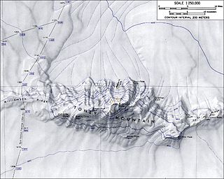
Williamson Ridge is a low snow-covered ridge, 10 nautical miles (18 km) long and 2 to 5 nautical miles (9 km) wide, that forms a western extension of Toney Mountain in Marie Byrd Land. It was mapped by United States Geological Survey (USGS) from ground surveys and U.S. Navy air photos, 1959–71. Named by Advisory Committee on Antarctic Names (US-ACAN) for Paul R. Williamson, ionospheric physicist at Byrd Station in two austral summers, 1967–68 and 1969–70.
Baker Ridge is a ridge extending west for 5 nautical miles (9 km) from the northern part of the Washington Escarpment in the Neptune Range, Pensacola Mountains. It was mapped by the United States Geological Survey from surveys and from U.S. Navy air photos, 1956–66, and named by the Advisory Committee on Antarctic Names for Clifford E. Baker, an aviation electronics technician at Ellsworth Station, winter 1958.
Coleman Nunatak is a nunatak located near the head of Berry Glacier, 2 nautical miles (4 km) south of Patton Bluff in Marie Byrd Land. It was mapped by the United States Geological Survey from surveys and from U.S. Navy air photos, 1959–65, and named by the Advisory Committee on Antarctic Names after Richard I. Coleman, United States Antarctic Research Program meteorologist at Byrd Station, 1962.
Strauss Glacier is a glacier, 40 nautical miles (70 km) long, flowing between the Ickes Mountains and Coulter Heights to enter the sea at the east side of Land Bay, Marie Byrd Land. Mapped by United States Geological Survey (USGS) from surveys and U.S. Navy air photos, 1959–65. The naming was proposed to Advisory Committee on Antarctic Names (US-ACAN) by Admiral Richard E. Byrd. Named for Lewis Strauss, Chairman of the Atomic Energy Commission, 1953–58, longtime friend and advisor to Admiral Byrd who recommended that the Antarctic be used to demonstrate peaceful employment of atomic energy.
Gregory Rock is a rock that outcrops above the ice slopes of western Hershey Ridge, 7 nautical miles (13 km) west-southwest of Linwood Peak, in the Ford Ranges of Marie Byrd Land, Antarctica. It was mapped by the United States Geological Survey from surveys and U.S. Navy air photos, 1959–65, and was named by the Advisory Committee on Antarctic Names for Elmer D. Gregory, aviation maintenance line crew supervisor at Williams Field, McMurdo Sound, during Operation Deep Freeze 1967.
Pope Glacier is a glacier about 20 nautical miles (37 km) long, flowing north along the west side of Mount Murphy to Crosson Ice Shelf on Walgreen Coast, in Marie Byrd Land. Mapped by United States Geological Survey (USGS) from surveys and U.S. Navy air photos, 1959–66. Named by Advisory Committee on Antarctic Names (US-ACAN) after Maj. Donald R. Pope, (CE) USA, civil engineer on the staff of the Commander, Naval Support Force, Antarctica, 1965–67.

Evans Glacier is a gently-sloping glacier 15 nautical miles (28 km) long and 4 nautical miles (7 km) wide, draining the southeast slopes of Travnik Buttress eastwards between Rugate Ridge and Poibrene Heights to flow into Vaughan Inlet on the east coast of Graham Land, Antarctica. It was discovered by Sir Hubert Wilkins in an aerial flight, December 20, 1928, and named "Evans Inlet" by him for E.S. Evans of Detroit. A further survey by the Falkland Islands Dependencies Survey in 1955 reported that this low-lying area is not an inlet, but is formed by the lower reaches of Hektoria Glacier and the feature now described.
Paschal Glacier is a glacier about 20 nautical miles (37 km) long and 4 nautical miles (7 km) wide, draining northwest between two ridges, the terminal points of which are Mount McCoy and Lewis Bluff. The lower end of this glacier merges with the flow of White Glacier and the larger Land Glacier near Mount McCoy before the latter feature debouches into Land Bay on the coast of Marie Byrd Land. Paschal Glacier was photographed from aircraft of the United States Antarctic Service (USAS), 1939–41, and was mapped by United States Geological Survey (USGS) from surveys and U.S. Navy aerial photography, 1959–65. Named by Advisory Committee on Antarctic Names (US-ACAN) for Evans W. Paschal, Scientific Leader at Byrd Station, 1970.
Manfull Ridge is a broad snow-covered ridge that descends gently from the north side of the Kohler Range about 5 nautical miles (9 km) west of Morrison Bluff, in Marie Byrd Land, Antarctica. It was mapped by the United States Geological Survey from ground surveys and U.S. Navy air photos, 1959–71, and was named by the Advisory Committee on Antarctic Names for Byron P. Manfull of the U.S. Department of State, Chairman of the Interagency Committee on Antarctica, 1967–69.
Thomas Glacier is a roughly Z-shaped glacier which drains the southeast slopes of Vinson Massif and flows for 17 nautical miles (31 km) through the south part of the Sentinel Range, Ellsworth Mountains, leaving the range between Doyran and Petvar Heights south of Johnson Spur.
Reed Ridge is a flat-topped, snow-covered ridge extending northwest for 3 nautical miles (6 km) from the west part of the Ford Massif, Thiel Mountains. The ridge forms the west wall of Compton Valley. Mapped by United States Geological Survey (USGS) from surveys and U.S. Navy air photos, 1959–61. Named by Advisory Committee on Antarctic Names (US-ACAN) for Dale R. Reed, ionospheric scientist at Ellsworth Station in 1958 and Byrd Station in 1960.
Reynolds Bench is a nearly flat bench, or mesa-like feature, 6 nautical miles (11 km) long and 2 nautical miles (3.7 km) wide, that has a smooth, snow-covered surface but has rock outcroppings along its steep sides. The feature stands at the north side of the Kelley Massif, to which it appears to be joined, along the south side of the upper Clifford Glacier in Palmer Land. Mapped by United States Geological Survey (USGS) in 1974. Named by Advisory Committee on Antarctic Names (US-ACAN) for Richard L. Reynolds, geologist with the USGS Lassiter Coast geologic and mapping party in 1970–71.

Lister Glacier is a glacier 5 nautical miles (9 km) long and 1 nautical mile (2 km) wide, draining the northeast slopes of Stribog Mountains and flowing into Bouquet Bay just south of Duclaux Point on the northeast side of Brabant Island, in the Palmer Archipelago, Antarctica.
References
![]() This article incorporates public domain material from "Reynolds Ridge". Geographic Names Information System . United States Geological Survey.
This article incorporates public domain material from "Reynolds Ridge". Geographic Names Information System . United States Geological Survey.
| | This Marie Byrd Land location article is a stub. You can help Wikipedia by expanding it. |