
The Menai Strait is a strait which separates the island of Anglesey from Gwynedd, on the mainland of Wales. It is situated between Caernarfon Bay in the south-west and Conwy Bay in the north-east, which are both inlets of the Irish Sea. The strait is about 25 km (16 mi) long and varies in width from 400 metres (1,300 ft) between Fort Belan and Abermenai Point to 7.5 kilometres (4.7 mi) between Puffin Island and Penmaenmawr. It contains several islands, including Church Island, on which is located St Tysilio's Church.

The Kingdom of Gwynedd was a Welsh kingdom and a Roman Empire successor state that emerged in sub-Roman Britain in the 5th century during the Anglo-Saxon settlement of Britain.
Newborough is a village in the southern corner of the Isle of Anglesey in Wales. It is a part of the Bro Aberffraw electoral ward; to the northwest is Aberffraw, and to the northeast is Llanfairpwll. There is a church in the village, and a public institute. Nearby is the Newborough Warren, a forest, beach, and public nature reserve.
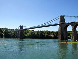
The Menai Suspension Bridge is a suspension bridge spanning the Menai Strait between the island of Anglesey and the mainland of Wales. Designed by Thomas Telford and completed in 1826, it was the world's first major suspension bridge. The bridge still carries road traffic and is a Grade I listed structure.

Aberffraw is a village and community on the south west coast of the Isle of Anglesey in Wales. The village is 9 miles from the island's capital, Llangefni, and is located is on the west bank of the Afon Ffraw. The community includes Soar and Dothan. Located near the A4080 and the nearest rail station is Bodorgan.

Ynys Gored Goch, sometimes Ynys Gorad Goch, is a small island in the Menai Strait between Gwynedd and Anglesey in north Wales. It is situated in the stretch of the strait called the Swellies between Thomas Telford's Menai Suspension Bridge and Robert Stephenson's Britannia Bridge.

The Isle of Anglesey County Council is the local authority for the Isle of Anglesey, a principal area with county status in Wales. Since 2022 the council has 35 councillors who represent 11 multi-member electoral wards.

Arfon was a mediaeval Welsh cantref in north-west Wales. It was the core of the kingdom of Gwynedd. Later it was included in the new county of Caernarfonshire, together with Llŷn and Arllechwedd under the terms of the Statute of Rhuddlan in 1284. The island of Anglesey faced it across the Menai Strait; to the east was the cantref of Arllechwedd, to the south the cantref of Eifionydd, and to the west was the cantref of Llŷn.
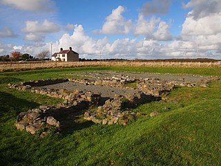
Llys Rhosyr, also known as "Cae Llys", is an archaeological site near Newborough in Anglesey; the ruins of a pre-Edwardian commotal court.

Llanidan is a community in the south of Anglesey, Wales which includes the village of Brynsiencyn. The parish is along the Menai Strait, about 4 miles north-east of Caernarfon. The parish church of St Nidan is near the A4080 highway, a little to the east of Brynsiencyn. The ruins of an earlier parish church survive.

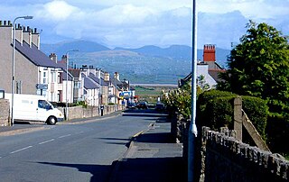
Llanfaes is a small village on the island of Anglesey, Wales, located on the shore of the eastern entrance to the Menai Strait, the tidal waterway separating Anglesey from the north Wales coast. Its natural harbour made it an important medieval port and it was briefly the capital of the kingdom of Gwynedd. Following Prince Madoc's Rebellion, Edward I removed the Welsh population from the town and rebuilt the port a mile to the south at Beaumaris. It is in the community of Beaumaris.

Aberffraw was one of the three medieval cantrefs on the island of Anglesey, north Wales, in the Kingdom of Gwynedd as a cadet branch, named the House of Aberffraw. It lay on the western side of the island on Caernarfon Bay. Its administrative centre was Aberffraw, the ancient seat of the Princes of Gwynedd. In the 1300s, it was ruled by viceroys from the lineage of Hwfa ap Cynnddelw who represented Anglesey in the parliament of 1327 regarding the deposition of Edward II of England.

The Isle of Anglesey is a county off the north-west coast of Wales. It is named after the island of Anglesey, which makes up 94% of its area, but also includes Holy Island and some islets and skerries. The county borders Gwynedd across the Menai Strait to the southeast, and is otherwise surrounded by the Irish Sea. Holyhead is the largest town, and the administrative centre is Llangefni. The county is part of the preserved county of Gwynedd.
Culture and Society in Gwynedd during the High Middle Ages refers to a period in the History of Wales spanning the 11th, 12th, and 13th centuries. The High Middle Ages were preceded by the Early Middle Ages and followed by the Late Middle Ages. Gwynedd is located in the north of Wales.
Arfon, from the Welsh for Facing Anglesey, refers to the southern shore of the Menai Strait, the part of mainland Wales closest to the island of Anglesey. It may refer to:
Dindaethwy was in medieval times one of two commotes of the cantref of Rhosyr, in the south-east of the Isle of Anglesey. It was between the Menai Strait and Conwy Bay, and the Irish Sea and Red Wharf Bay.

The Roman conquest of Anglesey refers to two separate invasions of Anglesey in North West Wales that occurred during the early decades of the Roman conquest of Britain in the 1st century CE. The first invasion of North Wales began after the Romans had subjugated much of southern Britain. It was led by the Provincial governor of Britannia, Suetonius Paulinus, who led a successful assault on the island in 60–61 CE, but had to withdraw because of the Boudican revolt. In 77 CE, Gnaeus Julius Agricola's thorough subjugation of the island left it under Roman rule until the end of Roman rule in Britain in the early 5th century CE. The invasions occurred because Anglesey, which was recorded in Latin as Mona was a place of resistance to Roman rule because it was an important centre for the Celtic Druids and their religious practices.
The Hughes-Hunter Baronetcy, of Plas Coch in the Parish of Llanedwen in the County of Anglesey, was a title in the Baronetage of the United Kingdom.

Malltraeth Marsh is a large marsh area in Anglesey, North Wales, north-east of Malltraeth village, along the flatlands of Trefdraeth, Bodorgan, Llangristiolus and south of Cefn Cwmwd, Rhostrehwfa. It was reclaimed from estuarine marshes after the construction of the Malltraeth Cob (dyke), a 1 mile (1.6 km) long embankment, and the subsequent canalisation in 1824 of the Afon Cefni.

The Battle of Anglesey Sound was fought in June or July 1098 on the Menai Strait, separating the island of Anglesey from mainland Wales. The battle was fought between Magnus Barefoot, King of Norway, and the Anglo-Norman earls Hugh of Montgomery and Hugh d'Avranches, and took place as part of Magnus Barefoot's expedition into the Irish Sea, which sought to assert Norwegian rule over the Kingdom of the Isles.
