Rhu Peninsula

Last updated

Rhu Peninsula
Scottish Gaelic: Rudha Arasaig
Rhu Peninsula map 1.svg
Rhu peninsula features map
Lochaber UK location map.svg
Red pog.svg
Rhu Peninsula
Coordinates: 56°53′24″N5°51′54″W / 56.890°N 5.865°W / 56.890; -5.865
LocationSW corner of South Morar in Lochaber, Scotland

Rhu Peninsula (Scottish Gaelic : Rudha Arasaig) and originally known as the Rhu Arisaig peninsula [1] is a small, remote and largely deserted peninsula, at the SW corner of South Morar in Lochaber Highland council area, on the west coast of Scotland. [2] Arisaig is located at the northeast corner of the peninsula. [2] In July 1745, Loch nan Uamh on the south coast of the peninsula was the landing spot for Prince Charles Edward Stuart. [2]

Contents

Geography

Elevation map of Rhu Peninsula Rhu Peninsula elevated thematic map 1.svg
Elevation map of Rhu Peninsula

Rhu peninsula is some five miles long with a maximum width of two miles, orientated on a west-by-south direction, on the west coast of Scotland, directly opposite the island of Eigg that sits some 7 miles from the western tip of the peninsula. The peninsula is largely forested at the east end. It has a tracked road running along the northern coast. The village of Arisaig is located on the coast to the north-east, slightly north of the peninsula. 7 miles (11 kilometres) north is the village of Mallaig.

Neolithic history

In 2013, a survey was conducted of the peninsula and it was noticed there was some faint stone markings located on an east-facing wall of an old stone building that was ruined. The marking's could only be seen in the right light, and it was fortuitous that those conditions were present, when the survey was conducted. [3] The markings written into the basalt consist of diamond and cross-pattern shapes, around 2mm in depth. [4] The stone which measures 290mm x 180mm x 200 mm has been examined in detail and has been dated between 4000-2300BC. [3] The building that contained the stone is no more than 200 years old and appears to be rebuilt over an older building. [3] The stone was moved to the Land, Sea and Islands Centre in Arisaig. [3]

Modern history

From the 13th century, the peninsula was part of the lands of the Clanranalds. [1] By the 18th century, the population was already declining steadily, like many other areas in the Highlands. This was caused by rapidly increasing rents, part of the social changes that started with the Jacobite rising of 1745. [5]

In 1827, Ranald George Macdonald, the 20th Chief of Clanranald, sold the peninsula to his second wife Ann Selby, Lady Ashburton for £48,950. [6] In 1835, Selby bequeathed it to her nephew, Lord James Cranstoun, who removed most of the tenants, who were mostly Roman Catholic [7] and turned it into a sheep farm. Most of the tenants emigrated to Australia. [7] Cranstoun subsequently sold it to Hugh Mackay of Bighouse, who sold it in 1848 to a Lancashire industrialist, who by 1853 had reforested 3000 acres of it, for deer hunting. [1] This accelerated the clearances. [1] In 1841 there were 134 people living on the peninsula, but by the 1861 census, the number had reduced to 40 people in 7 households. [1]

Geology

The bedrock of the peninsula is largely metamorphic sandstones consisting of psammites and pelites with exposed intrusive bands of basalt. [1] The breakdown of the sandstone results in poor soils, although basalt produces better soil. [1] Ridges are formed by the basalt on a north to south orientation at lengths of 70 to 100 metres (230 to 330 ft). [1] Between the ridges are short glens that are mostly boggy, but there is evidence that at one time they were drained. Sea level changes over the millennia have left raised beaches, in places 25 metres above current sea levels, making cultivation difficult, as there is a layer of smooth stones just below the surface. [1] A wet climate, combined with the low-lying land at 103 metres (338 ft) above sea level in the west, makes farming very difficult. [1]

Related Research Articles

<span class="mw-page-title-main">Small Isles</span> Island group off the west coast of Scotland

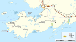
The Small Isles are a small archipelago of islands in the Inner Hebrides, off the west coast of Scotland. They lie south of Skye and north of Mull and Ardnamurchan – the most westerly point of mainland Scotland.

<span class="mw-page-title-main">Argyll</span> Historic county in Scotland

Argyll, sometimes called Argyllshire, is a historic county and registration county of western Scotland.

<span class="mw-page-title-main">Eigg</span> Island of Scotland

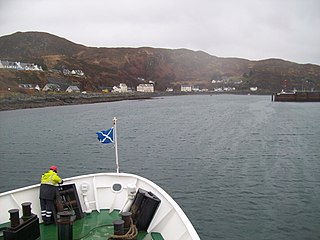
Eigg is one of the Small Isles in the Scottish Inner Hebrides. It lies to the south of the Isle of Skye and to the north of the Ardnamurchan peninsula. Eigg is 9 kilometres long from north to south, and 5 km (3 mi) east to west. With an area of 12 sq mi (31 km2), it is the second-largest of the Small Isles after Rùm. Eigg generates virtually all of its electricity using renewable energy.

<span class="mw-page-title-main">Mallaig</span> Scottish Highland port

Mallaig is a port in Lochaber, on the west coast of the Highlands of Scotland. The local railway station, Mallaig, is the terminus of the West Highland railway line and the town is linked to Fort William by the A830 road – the "Road to the Isles".

Arisaig is a village in Lochaber, Inverness-shire. It lies 7 miles south of Mallaig on the west coast of the Scottish Highlands, within the Rough Bounds. Arisaig is also the traditional name for part of the surrounding peninsula south of Loch Morar, extending east to Moidart. Etymologically, Arisaig means "safe bay". It lies in the Scottish council area of Highland and has a population of about 300.

<span class="mw-page-title-main">A830 road</span> Road in the Scottish Highlands

The A830, also known as the Road to the Isles is a major road in Lochaber, Scottish Highlands. It connects the town of Fort William to the port of Mallaig.

<span class="mw-page-title-main">Morar</span> Human settlement in Scotland

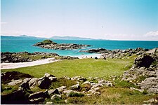
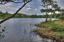
Morar is a small village on the west coast of Scotland, 3 miles (5 km) south of Mallaig. The name Morar is also applied to the northern part of the peninsula containing the village, though North Morar is more usual. The coastline of the area forms part of the Morar, Moidart and Ardnamurchan National Scenic Area, one of 40 such areas in Scotland, which are defined so as to identify areas of exceptional scenery and to ensure its protection by restricting certain forms of development.

<span class="mw-page-title-main">Ronay</span>

Ronay is an island in the Outer Hebrides of Scotland, which lies a short distance off the east coast of Grimsay.

Moidart is part of the remote and isolated area of Scotland, west of Fort William, known as the Rough Bounds. Moidart itself is almost surrounded by bodies of water. Loch Shiel cuts off the eastern boundary of the district and continues along part of the southern edge. The remainder of the southern edge is cut off by Loch Moidart. The north is cut off by Loch Morar and Loch Ailort.

<span class="mw-page-title-main">Sound of Arisaig</span>

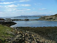
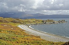
The Sound of Arisaig Lochaber, Scotland, separates the Arisaig peninsula to the north from the Moidart peninsula to the south. At the eastern, landward end, the sound is divided by Ardnish into two sea lochs. Loch nan Uamh lies to the north of Ardnish, Loch Ailort to the south. There are a number of small islands in the sound, of which Eilean nan Gobhar and Samalaman Island, both near to Glenuig on the south shore, are the largest.

<span class="mw-page-title-main">Loch Ailort</span> A sea loch in the Highlands of Scotland

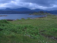
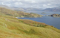
Loch Ailort is a sea loch in Morar, Lochaber, Highland, Scotland. Loch Ailort is a shallow V shaped loch, with the small Ardnish Peninsula on the north side, and the large southwest facing Moidart Peninsula to the south. Loch Ailort is bounded in the northeast by the settlement of the same name, Lochailort and in the west, opening out into the Sound of Arisaig. To the north of the loch lies Loch nan Uamh.

This is a list of islands in Scotland with the name Garbh Eilean or similar, meaning "rough island" in Scottish Gaelic.

<span class="mw-page-title-main">Prince's Cairn</span> Cairn in Beasdale

The Prince's Cairn marks the traditional spot from where Prince Charles Edward Stuart embarked for France from Scotland on 20 September 1746 following the failure of the Jacobite rising of 1745. The cairn is located on the shores of Loch nan Uamh in Lochaber. It was erected in 1956 by the 1745 Association, a historical society dedicated to the study, recording and preservation of memories from the Jacobite period.

<span class="mw-page-title-main">Inverness-shire</span> Historic county in Scotland

Inverness-shire is a historic county, registration county and lieutenancy area of Scotland. Covering much of the Highlands and Outer Hebrides, it is Scotland's largest county, though one of the smallest in population, with 67,733 people or 1.34% of the Scottish population.

<span class="mw-page-title-main">Skirmish of Arisaig</span>

The Skirmish of Arisaig took place on 16 May 1746 at Arisaig, Scotland and was the last armed conflict of the Jacobite rising of 1745. It was fought between a British Government force and Jacobites of the Clan Macdonald of Clanranald.

<span class="mw-page-title-main">Loch Beag</span>

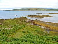
Loch Beag is a cove on the west coast of Northern Scotland, in the vicinity of the Sound of Arisaig. The eastern end of the Sound of Arisaig divides into Loch nan Uamh in the north and Loch Ailort in the south separated by a headland. Loch Beag is an inlet at the eastern end of Loch nan Uamh. It is 1.2 kilometres (0.75 mi) long and 0.5 kilometres (0.31 mi) wide, with a maximum depth of 21 metres (69 ft).

<span class="mw-page-title-main">Morar, Moidart and Ardnamurchan National Scenic Area</span>

Morar, Moidart and Ardnamurchan is a national scenic area (NSA) covering the coastal scenery of three peninsulas in the western Highlands of Scotland: Ardnamurchan, Moidart and Morar. It is one of 40 such areas in Scotland, which are defined so as to identify areas of exceptional scenery and to ensure its protection from inappropriate development by restricting certain forms of development. The Morar, Moidart and Ardnamurchan NSA covers 36,956 ha in total, consisting of 17,220 ha of land with a further 19,736 ha being marine.

References

  1. 1 2 3 4 5 6 7 8 9 10 "Rhu Arisaig - An archaeological survey of the Rhu Peninsula completed between 2012 & 2016" (pdf). Highland Government. Library: Rough Bounds Archaeology. November 2016. Retrieved 30 June 2020.
  2. 1 2 3 Gittings, Bruce; Munro, David. "Arisaig". The Gazetteer for Scotland. School of GeoSciences, University of Edinburgh and The Royal Scottish Geographical Society. Retrieved 30 June 2020.
  3. 1 2 3 4 "MHG56817 - Neolithic incised stone - Rhu Peninsula, Arisaig and Moidart". Highland Historic Environment Record. The Highland Council. Retrieved 1 November 2021.
  4. Bowker, Ken (2013). "Carved Stone (Neolithic) - Details". Canmore. Historic Environment Scotland. Retrieved 1 November 2021.
  5. Rixson, Denis (2002). Arisaig and Morar : a history. East Linton, Scotland: Tuckwell Press. ISBN   1862321248. OCLC   51108683.
  6. "Arisaig, General". Canmore. National Record of the Historic Environment. Retrieved 1 July 2020.
  7. 1 2 John G. Gibson (4 July 2017). Gaelic Cape Breton Step-Dancing: An Historical and Ethnographic Perspective. MQUP. p. 150. ISBN   978-0-7735-5061-2 . Retrieved 25 July 2020.