Ribat of Arrifana

Last updated
Ribat of Arrifana
Ribat da Arrifana
Vista Aerea do Ribat da Arrifana - 02.09.2023.jpg
Aerial view of Ribat of Arrifana
Ribat of Arrifana
Location Aljezur, Faro (district), Algarve, Portugal
Coordinates 37°19′14″N8°52′37″W / 37.32056°N 8.87694°W / 37.32056; -8.87694
Type Excavations
History
Founded1130
Abandoned1151
CulturesMuslims in Iberia
Site notes
Excavation datessince 2001
ArchaeologistsRosa Varela Gomes and Mário Varela Gomes
OwnershipPrivate
Public accessYes

The Ribat of Arrifana is the archeological site of the remains of a Muslim fortification (ribat) situated in Arrifana, Aljezur municipality, in the Faro District of the Algarve region, Portugal. It was a Muslim coastal fortress built around 1130 and is the only such Muslim fortress to have been identified in Portugal, having been excavated by Portuguese archaeologists since 2001.

Contents

History

The ribat is located on the Ponta da Atalaia, about 1 km north of Arrifana Beach. It was constructed around 1130, probably by the Sufi and Mahdi master of Christian origin, Abu-l-Qasim Ahmad ibn al-Husayn ibn Qasi, one of the leading political and religious figures in al-Andalus, the Muslim territory that covered most of Iberia during the Islamic Golden Age. Between 1130 and 1140 Ibn Qasi wrote his main work, The Removal of the Sandals, which was inspired by both the Old Testament and the Quran. In 1151 he was assassinated in Silves after being accused of betraying Islam by the followers of Abd al-Mu'min and Ibn Almúndir. After this the Ribat of Arrifana was abandoned, with the English crusader and chronicler, Roger of Hoveden, reporting forty years later that it was “recognizable but in ruins”. It is believed that the minaret was used as a watchtower in the fourteenth century. Despite appearing in written records dating back to 1786 and being clearly identifiable as a former inhabited area as late as 1841, [1] the location of the ribat was only identified by archaeologists at the beginning of this millennium. Its architectural features are inspired by the ribats identified in North Africa. [2] [3] [4] [5]

Excavations

In addition to protection against invaders the ribat was dedicated to prayer, containing eight mosques with qibla and mihrab oratories where warrior monks prayed, as well as a minaret, a madrasa and accommodation. These structures were built in mud on stone foundations, with floors mostly of beaten earth, with wood coverings and straw roof tiles. A building located in the north-eastern part of the necropolis provided a bench, storage for water, and a basin dug in the soil. The floor and walls were well-coated with lime. Excavations by the Faculty of Social and Human Sciences of the New University of Lisbon have identified decorated amulets, remains of tableware and kitchenware, as well as pottery for storage. Brass items used for weaving, such as a spindle, have also been found, together with iron weapons, including a dagger, a sword, a spear, and arrowheads. Items related to fishing and mollusc harvesting have also been identified. A long fragment of bone is believed to have been part of a musical instrument. [3] [4] [6] [7] [8]

Also found partially within the confines of the ribat was a necropolis. Sixty-one graves have been discovered orientated northeast-southwest, indicating the burial of the corpses with the face turned towards Mecca. Some graves assumed to be Christian were also identified. Text found on some of the gravestones or stele predated the construction of the ribat and it is unclear whether the epitaphs were ‘’’in situ’’’ at the site when the Ribat of Arrifana was built, whether they were transferred from a small village nearby, or whether the stones were simply reused. The corpses were buried in pits with their arms gathered tightly to their abdomen and legs slightly bent. Of the corpses examined, no signs of violence were detected as a cause of death, nor severe bone trauma or infections. Dental caries constituted the most common pathology. There was also considerable evidence of anemia. [6] [8]

Logistical and financial support for the excavation work was provided by Aljezur municipality, the Calouste Gulbenkian Foundation and the Max van Berchem Foundation. [6]

See also

Related Research Articles

<span class="mw-page-title-main">Almohad Caliphate</span> 1121–1269 Berber empire in North Africa and Iberia

The Almohad Caliphate was a North African Berber Muslim empire founded in the 12th century. At its height, it controlled much of the Iberian Peninsula (Al-Andalus) and North Africa.

<span class="mw-page-title-main">Algarve</span> Region in Portugal

The Algarve is the southernmost NUTS II region of continental Portugal. It has an area of 4,997 km2 (1,929 sq mi) with 467,495 permanent inhabitants and incorporates 16 municipalities.

<span class="mw-page-title-main">Silves, Portugal</span> Municipality in Algarve, Portugal

Silves is a city and municipality in the Portuguese region of Algarve, in southern Portugal. The population of the entire municipality of Silves in 2011 was 37,126, in an area of 680.06 km2. The urbanized area of the city proper has approximately 11,000 inhabitants. Silves is the former capital of the Kingdom of the Algarve (1249–1910), a nominal kingdom within the Kingdom of Portugal (1139-1910), and is of great historical importance.

<span class="mw-page-title-main">Abd al-Mu'min</span> Founder and Caliph of the Almohad Caliphate from 1133 to 1163

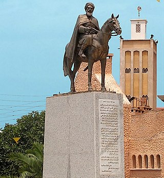
Abd al Mu'min was a prominent member of the Almohad movement. Although the Almohad movement itself was founded by Ibn Tumart, Abd al-Mu’min was the founder of the Almohad dynasty and creator of the dynasty's empire. As a leader of the Almohad movement he became the first Caliph of the Almohad Empire in 1133, after the death in 1130 of the movement's founder, Ibn Tumart, and ruled until his death in 1163. Abd al-Mu'min put his predecessor's doctrine of Almohadism into practice, defeated the Almoravids in present-day Morocco, and extended his rule across Al-Andalus and as far as Tunis in Ifriqiya, thus bringing the Maghreb in North Africa and Al-Andalus in Europe under one creed and one government.

<span class="mw-page-title-main">São Brás de Alportel</span> Municipality in Algarve, Portugal

São Brás de Alportel is a town and municipality in the District of Faro, Algarve region, in Portugal. The population in 2011 was 10,662, in an area of 153.37 km². The present Mayor is Vítor Guerreiro, elected by the Socialist Party. The municipal holiday is June 1.

<span class="mw-page-title-main">Vila do Bispo</span> Municipality in Algarve, Portugal

Vila do Bispo is a municipality (concelho) in the Portuguese Algarve. It has 5,717 inhabitants in an area of 179.06 km2.

<span class="mw-page-title-main">Arrifana (Aljezur)</span> Village in Algarve, Portugal

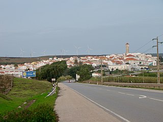
Arrifana is a small parish and fishing village in the Faro District's Aljezur Municipality in the Barlavento Algarvio region of Portugal. It is situated near the border between the Aljezur and Alentejo regions on the coast of the Atlantic Ocean and is within the Costa Vicentina park. Arrifana is located about 6 km from Aljezur.

<span class="mw-page-title-main">Escoural Cave</span> Cave and archaeological site in Portugal

The Prehistoric Rock-Art Site of Escoural Cave is a structure known for its Paleolithic-era rock-art and funerary burial site, located in the Portuguese municipality of Montemor-o-Novo, in the civil parish of Santiago do Escoural.

<span class="mw-page-title-main">Castle of Silves</span> Moorish fortification in Algarve, Portugal

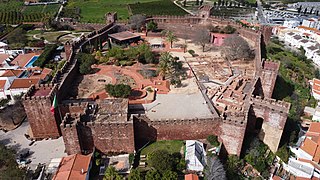
The Castle of Silves is a castle in the civil parish of Silves in the municipality of Silves in the Portuguese Algarve. It's believed that the first fortifications were built upon a possible Lusitanian castro, by the Romans or Visigoths. Between the 8th and 13th centuries, the castle was occupied by the moors who expanded it, making it one of the best preserved Moorish fortifications in Portugal, resulting in its classification as a National Monument in 1910.

<span class="mw-page-title-main">Castle of Aljezur</span> Medieval castle in Aljezur, Portugal

The Castle of Aljezur is a medieval castle founded in the parish of Aljezur, in the municipality of the same name overlooking the Aljezur River. Excavations in the castle have discovered that the location was occupied during the Bronze and Iron Ages, while the parade grounds, habitational structures, and two silos date to the 12th and 13th centuries.

<span class="mw-page-title-main">Castle of Alvor</span> Medieval castle in Alvor, Faro, Portugal

The Castle of Alvor is a medieval castle in the civil parish of Alvor, in the Portuguese district of Faro: considered to be a significant military monument associated with the nearby Castle of Silves.

<span class="mw-page-title-main">Aljezur</span> Municipality in Algarve, Portugal

Aljezur is a town and municipality of the District of Faro and Algarve region, in Portugal. The population in 2011 was 5,884, in an area of 323.50 km². The municipality comprises 4 parishes.

Castle of Cola is an Iron Age residence and Islamic redoubt in the Portuguese Alentejo, classified as a National Monument. The castro is part of a larger archaeological park of Castro da Cola, that includes various Megalithic and Calcolithic monuments, including necropolises of the Bronze and Iron Ages. The Castro-era polygonal plan, included reinforced blocks, with an entrance controlled by tower. The remaining defensive structure was circled by walls, with still exist, on the neighboring pasture-lands protecting the castle.

<span class="mw-page-title-main">Praia de Monte Clérigo</span> Beach in Algarve, Portugal

Praia do monte Clérigo is a beach within the municipality of Aljezur, in Algarve, Portugal. The beach is on the western Seaboard in the north west of the Algarve. The beach is 5.1 miles (8.2 km) north west of the village of Aljezur, and is 70.0 miles (112.7 km) north west, by road, from the regions capital of Faro. Praia do monte Clérigohas been designated a blue Flag beach (2012).

<span class="mw-page-title-main">Praia da Arrifana</span> Portuguese beach

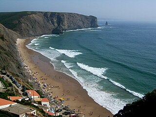
Praia da Arrifana is a beach within the Municipality of Aljezur, in the Algarve, Portugal. The beach is on the western Seaboard in the north west of the Algarve. The beach is 6.0 miles (9.7 km) south south west of the village of Aljezur, and is 71.0 miles (114.3 km) north west, by road, from the regions capital of Faro. The beach of Praia da Arrifana is inside the Vicentine Coast Natural Park, an area of outstanding natural beauty. Praia da Arrifana has been designated a blue Flag beach (2012).

<span class="mw-page-title-main">Islamic Fishing Village, Carrapateira</span> Archaeological site near Carrapateira, Portugal

The Islamic Fishing Village is an archaeological site close to the town of Carrapateira in the municipality of Aljezur, Algarve Region of Portugal. The site was excavated by a team of researchers from the New University of Lisbon in 2001. This permitted the settlement to be dated to the 12th and 13th centuries, during the Almohad Caliphate at the end of the Muslim occupation of the Algarve.

<span class="mw-page-title-main">Fort of Arrifana</span> Bastion forts in Portugal

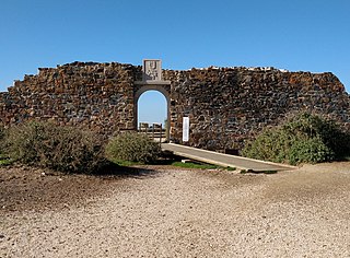
The Fort of Arrifana, or Fortress of Arrifana, ) is situated on the Vicentine Coast of the Algarve region of Portugal, on a promontory close to the town of Aljezur. It was originally constructed in 1635 with the intention of protecting fishing grounds for tuna as well as defending the coast. Its location provides a natural lookout over Arrifana Beach and the Vicentine Coast.

<span class="mw-page-title-main">Fort of Almádena</span> Bastion forts in Portugal

The Fort of Almádena or, also known as the Fort of the River Mouth, is located between the towns of Salema and Burgau, in the Algarve region of Portugal. It was constructed in 1632. Damaged by the 1755 earthquake, it was abandoned in 1849.

<span class="mw-page-title-main">Fort São Vicente (Sagres)</span> Bastion forts in Portugal

Fort São Vicente is a military monument in Sagres, in the Algarve region of Portugal. It consists of the remains of a fortification, with a lighthouse inside. It was built in the 16th century to protect a coastal strip and an existing monastery on the site. In 1587 it was destroyed by British privateer Francis Drake, and rebuilt in 1606. In the mid-19th century, a lighthouse was built on the site, which was replaced by a new one in the early 20th century. In the mid-2000s, Cape São Vicente was closed to the public for construction work.

References

  1. "Ribat da Arrifana". Fortalezas.org. Retrieved 21 December 2018.
  2. "Arrifana's Ribat". Natural.pt. Retrieved 21 December 2018.
  3. 1 2 "Ribat da Arrifana". Aljezur municipality. Retrieved 21 December 2018.
  4. 1 2 Gomes, Rosa Varela. "The Arrifana Ribat (Algarve). Sacred space and ideological context (12th century)". Academia. Retrieved 21 December 2018.
  5. "O Ribat da Arrifana". Vale da Telha. Retrieved 21 December 2018.
  6. 1 2 3 Varela Gomes, Rosa. "The Arrifana Ribât (Algarve. The Study of the Necropolis, 2014". Fondation Max van Berchem. Retrieved 21 December 2018.
  7. "Cemitério com 900 anos do Rîbat da Arrifana investigado por arqueólogos". Sul Informação. Retrieved 21 December 2018.
  8. 1 2 Varela Gomes, Rosa and Mario. "O Ribat da Arrifana (Aljezur, Algarve) Resultados da campanha de escavações arqueológicas de 2002" (PDF). Patrimonio Cultural. Retrieved 21 December 2018.