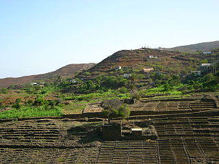
Ribeira da Cruz is a settlement in the northwestern part of the island of Santo Antão, Cape Verde. Situated 22 km northwest of the island capital Porto Novo, it is part of the parish of Santo André, in the municipality of Porto Novo. It had 421 inhabitants at the 2010 census.

Principal is a settlement in the northern part of the island of Santiago, Cape Verde. It is part of the municipality of São Miguel. The settlement consists of several localities along the river Ribeira Principal, including Chão de Horta, Hortelão, Jaqueitão and Mato Curral. In 2010 its population was 1,193. Hortelão is 4 km north of the summit of the Serra Malagueta and 7 km northwest of Calheta de São Miguel.

Ribeira da Barca is a town in the municipality of Santa Catarina, on the island of Santiago, Cape Verde. In 2010 its population was 2,317. It is situated on the west coast, at the mouth of the stream Ribeira da Barca, 11 km northwest of Assomada. The settlement was mentioned as "Rivera das Baras" in the 1747 map by Jacques-Nicolas Bellin.

Porto Mosquito is a settlement in the southern part of the island of Santiago, Cape Verde. It is situated on the south coast, 10 km northwest of Cidade Velha. It is part of the municipality of Ribeira Grande de Santiago.
Porto Gouveia is a settlement in the southern part of the island of Santiago, Cape Verde. It is situated on the south coast, 7 km northwest of Cidade Velha. It is part of the municipality of Ribeira Grande de Santiago.
Santana is a settlement in the southern part of the island of Santiago, Cape Verde. It is part of the municipality of Ribeira Grande de Santiago. It is situated 2 km east of Belém and 9 km northwest of Cidade Velha.
João Varela is a settlement in the southern part of the island of Santiago, Cape Verde. It is situated 5 km northeast of Cidade Velha and 9 km northwest of the capital Praia. It is part of the municipality of Ribeira Grande de Santiago.
Achada Monte is a town in the northern part of the island of Santiago, Cape Verde and is part of the municipality of São Miguel. It is situated near the east coast, 8 km northwest of Calheta de São Miguel. In 2010 its population was 1,652. It is on the road connecting Praia and Tarrafal through Pedra Badejo, the EN1-ST02. The small bay Mangue de Sete Ribeiras is located east of the settlement. Ribeira Principal flows west of the village.
Figueira das Naus is a settlement in the western part of the island of Santiago, Cape Verde. It is part of the municipality of Santa Catarina. In 2010 its population was 1,157. It is situated 11 km south of Tarrafal and 12 km northwest of Assomada. It is situated on the secondary road connecting Fundura and Ribeira da Prata.
Alto Mira is a settlement in the northwestern part of the island of Santo Antão, Cape Verde. It is situated 4 km southeast of Ribeira da Cruz and 18 km northwest of the island capital Porto Novo. Its population was 1,003 at the 2010 census. The Moroços Natural Park lies east of the settlement. The settlement is divided into several localities, including Chã Bonita, Chã Daurinca, Chã de Dragoeiro, Dominguinhas, Faial and Lombo Gorado. The Ribeira Alto Mira flows through the settlement.
Lombo Santa is a settlement in the northern part of the island of Santo Antão, Cape Verde. It is situated in the upper valley of the river Ribeira Grande, 10 km southwest of the town Ribeira Grande and 16 km northwest of the island capital Porto Novo.
Cabeçalinho is a settlement in the western part of the island of São Nicolau, Cape Verde. In 2010 its population was 155. It is situated 3 km southwest of Ribeira Brava and 6 km northeast of Tarrafal de São Nicolau. To its northwest is Monte Gordo.
Ribeira Alta is a settlement in the northern part of the island of Santo Antão, Cape Verde. It is situated in a mountain valley near the north coast, 19 km northwest of the island capital Porto Novo.
Covoada is a settlement in the northern part of the island of São Nicolau, Cape Verde. It is situated 7 km northwest of Ribeira Brava.
Garça de Cima is a settlement in the northern part of the island of Santo Antão, Cape Verde. It is situated in the upper valley of the river Ribeira da Garça, 15 km northwest of the island capital Porto Novo. The southernmost part lies in Moroços Natural Park.
Preguiça is a settlement in the central part of the island of São Nicolau, Cape Verde. It is situated on the south coast, 6 km south of Ribeira Brava. It served as the port of Ribeira Brava, after the older Porto de Lapa, 6 km to the northeast, had been abandoned in 1653 due to pirate attacks. The settlement was mentioned as Paraghisi in the 1747 map by Jacques-Nicolas Bellin. In 1820 the Forte do Príncipe Real, now ruined, was built to protect the port. Preguiça's port consists of a stone quay and a short mole. Preguiça Airport is located 3 km north of the village.
Queimadas is a settlement in the central part of the island of São Nicolau, Cape Verde. It is situated 3 km northwest of Ribeira Brava. It is part of the municipality of Ribeira Brava and the parish of Nossa Senhora da Lapa.
Ribeira dos Calhaus is a settlement in the western part of the island of São Nicolau, Cape Verde. It is part of the municipality of Tarrafal de São Nicolau. It is situated in a valley northwest of Monte Gordo, 3 km southeast of Praia Branca and 7 km north of Tarrafal de São Nicolau.
Chã de Pedras is a settlement in the northcentral part of the island of Santo Antão, Cape Verde. In 2010 its population was 1,266. It is situated about 5 km south of Coculi, 8 km southeast of the city Ribeira Grande and 12 km northwest of the island capital Porto Novo. It consists of 21 localities in the valley of the Ribeira de Chã de Pedras, a right tributary of the Ribeira Grande. The elevation of the largest village, Pia de Cima, is about 430 metres.


