Ribeira do Paul

Last updated
Ribeira do Paul
ValeRibeiraPaul.JPG
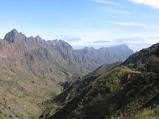
Ribeira and Vale do Paul near Eito
Country Cape Verde
Physical characteristics
Source 
 - locationnear Cabo da Ribeira, Santo Antão
River mouth  
 - location Atlantic Ocean
 - coordinates 17°09′00″N25°00′50″W / 17.1500°N 25.0138°W / 17.1500; -25.0138 Coordinates: 17°09′00″N25°00′50″W / 17.1500°N 25.0138°W / 17.1500; -25.0138

Ribeira do Paul is a seasonal stream that flows in the northeastern part of the island of Santo Antão in Cape Verde. The stream flows from southwest to northeast. The upper part of the valley belongs to Cova-Paul-Ribeira da Torre Natural Park. [1]

Santo Antão, Cape Verde Westernmost and largest of the Barlavento islands of Cape Verde

Santo Antão is the westernmost island of Cape Verde. At 779 km2 (301 sq mi), it is the largest of the Barlavento Islands group, and the second largest island of Cape Verde. The nearest island is São Vicente to the southeast, separated by the sea channel Canal de São Vicente. Its population was 40,547 in 2015, making it the third most populous island of Cape Verde after Santiago and São Vicente. Its largest city is Porto Novo on the south coast.

Cape Verde Country comprising ten islands off the Northwest coast of Africa

Cape Verde or Cabo Verde, officially the Republic of Cabo Verde, is an island country spanning an archipelago of 10 volcanic islands in the central Atlantic Ocean. It forms part of the Macaronesia ecoregion, along with the Azores, Canary Islands, Madeira, and the Savage Isles. In ancient times these islands were referred to as "the Islands of the Blessed" or the "Fortunate Isles". Located 570 kilometres (350 mi) west of the Cape Verde Peninsula off the coast of Northwest Africa, the islands cover a combined area of slightly over 4,000 square kilometres (1,500 sq mi).

Cova-Paul-Ribeira da Torre Natural Park

Cova-Paul-Ribeira da Torre Natural Park, in the east of the island of Santo Antão, is one of ten "natural parks" in the country of Cape Verde. Its area is 20.92 km2 (8.08 sq mi), of which 8.91 km2 (3.44 sq mi) in the municipality of Ribeira Grande, 8.85 km2 (3.42 sq mi) in the municipality of Paul and 3.16 km2 (1.22 sq mi) in the municipality of Porto Novo. Since 2016, the natural park is on the tentative list of World Heritage sites.

The Valley at Paul on Santo Antao, Cape Verde.jpg
Valle de Paul.JPG

The sources of the stream Ribeira do Paul are northeast of the Cova crater, near the settlement Cabo da Ribeira. It flows through a narrow and steep gorge, along the settlements Campo de Cão and Eito, and flows into the Atlantic Ocean at the town of Pombas. There is small-scale agriculture in the valley, producing sugar cane, coffee, yam, banana, papaya and mango. [2]

Cova (crater)

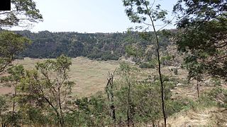
Cova is a volcanic caldera in the eastcentral part of the island of Santo Antão in Cape Verde. It is situated at the southwestern end of the municipality of Paul. Its lowest point is 1,166 meters, and the highest point of the crater rim is about 1,500 m. The diameter of the caldera is about 1.0 km. It forms a part of Cova-Paul-Ribeira da Torre Natural Park. The Cova formation dates from between 1.4 million and 700,000 years ago.

Cabo da Ribeira Settlement in Santo Antão, Cape Verde

Cabo da Ribeira is a settlement in the eastern part of the island of Santo Antão, Cape Verde. In 2010 its population was 912. It is situated at about 500 m elevation in the upper valley of the Ribeira do Paul, 5 km southwest of Pombas. It is part of the municipality of Paul, and lies in the Cova-Paul-Ribeira da Torre Natural Park.

Eito Settlement in Santo Antão, Cape Verde

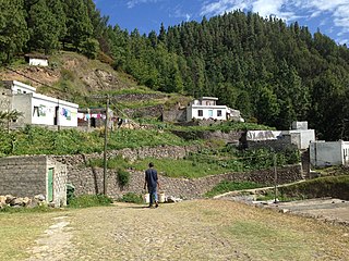
Eito is a village in the northeastern part of the island of Santo Antão, Cape Verde, part of the municipality of Paul. It is situated 1 km southwest of Pombas, 2 km northeast of Figueiral and 15 km northeast of the island capital Porto Novo. Its population was 979 in 2010.

See also

Related Research Articles

Ribeira, Portuguese and Galician for stream or riverside, may refer to the following places:

Ribeira Grande, Cape Verde (municipality) Municipality in Santo Antão, Cape Verde

Ribeira Grande is a concelho (municipality) of Cape Verde. Situated in the northern part of the island of Santo Antão, it covers one fifth of the island area, and is home to nearly half of its population. Its seat is the city Ponta do Sol.

Paul, Cape Verde Municipality in Santo Antão, Cape Verde

Paul is a concelho (municipality) of Cape Verde. Situated in the northeastern part of the island of Santo Antão, it covers 7% of the island area, and is home to 16% of its population. Its seat is the town Pombas.

Pico da Cruz mountain in Cape Verde

Pico da Cruz is a mountain in the eastern part of the island of Santo Antão. Its elevation is 1585 m. It is 5 km southwest of the town Pombas (Paul). It gives its name to the nearby village of Pico da Cruz, part of the municipality of Paul. Pico da Cruz is part of the protected area Cova-Paul-Ribeira da Torre Natural Park.

Corda, Ribeira Grande Settlement in Santo Antão, Cape Verde

Corda is a settlement in the island of Santo Antão, Cape Verde. It is part of the municipality Ribeira Grande. It is situated in the mountainous interior of the island at about 1,000 meters elevation, 13 km north of the island capital Porto Novo. It consists of several villages, including Chã de Corda and Esponjeiro. The national road from Porto Novo to Ribeira Grande (EN1-SA01) passes through Corda. The crater of Cova lies 4 km to the southeast. Corda lies in the Cova-Paul-Ribeira da Torre Natural Park.

Janela, Cape Verde Settlement in Santo Antão, Cape Verde

Janela is a settlement in the eastern part of the island of Santo Antão, Cape Verde. It is situated on the Atlantic coast, 4 km southeast of Pombas and 14 km northeast of the island capital Porto Novo The central village, Pontinha, lies on a rocky peninsula. More villages are situated in the valley of the river Ribeira da Janela. The national road from Porto Novo to Pombas (EN1-SA03) passes through Janela.

Ribeira da Janela is a stream in the eastern part of the island of Santo Antão in Cape Verde. The stream flows from southwest to northeast. Its source is east of Pico da Cruz and it empties into the Atlantic Ocean in the settlement Janela, west of the village Pontinha.

Ribeira da Garça river in Cape Verde

Ribeira da Garça is a river in the northern part of the island of Santo Antão in Cape Verde. Its source is on the north side of the eastern plateau of the island, northeast of Pico Moroços. It flows north through the settlements of Garça de Cima and Chã de Igreja, in the western part of the municipality of Ribeira Grande. It flows into the Atlantic Ocean near Chã de Igreja.

Ribeira Grande (stream) river in Cape Verde

Ribeira Grande is a stream in the northeastern part of the island of Santo Antão in Cape Verde. The stream flows from west-southwest to east-northeast, through a steep and narrow gorge. The river begins near Lombo Santa, passes through Boca de Ambas Ribeiras, Boca de Coruja and Coculi, and flows into the Atlantic Ocean at the town of Ribeira Grande. Its most important tributaries are the Ribeira de Chã das Pedras, and the Ribeira da Torre, that joins the Ribeira Grande in the town Ribeira Grande.

Ribeira da Torre river in Cape Verde

Ribeira da Torre is a torrential stream in the northeastern part of the island of Santo Antão in Cape Verde. Its source is in the mountains north of the Cova crater, near the locality Rabo Curto. It flows to the north through the settlements Xoxo, Fajã Domingas Benta and Lugar de Guene. In the city Ribeira Grande it flows into the river Ribeira Grande, just upstream of its outflow into the Atlantic Ocean. Its upper valley is part of the protected area Cova-Paul-Ribeira da Torre Natural Park. There is small-scale agriculture in the valley, producing sugar cane, coffee, yam, banana, papaya and mango.

Xoxo, Cape Verde Settlement in Santo Antão, Cape Verde

Xoxo is a settlement in the northeastern part of the island of Santo Antão in Cape Verde. It is situated 5 kilometres (3.1 mi) south of Ribeira Grande and 13 kilometres (8.1 mi) north of the island capital Porto Novo. The settlement lies in Cova-Paul-Ribeira da Torre Natural Park. The Ribeira da Torre flows through the settlement. The only road to Xoxo goes from Ribeira Grande through the Ribeira da Torre valley.

Pico da Cruz (village) Settlement in Santo Antão, Cape Verde

Pico da Cruz is a settlement in the northeastern part of the island of Santo Antão, Cape Verde. In 2010 its population was 138. It is situated 6 km southwest of Pombas and 10 km northeast of the island capital Porto Novo. Its elevation is about 1,400 meters. The village is named after the nearby mountain Pico da Cruz. It lies in the Cova-Paul-Ribeira da Torre Natural Park.

Ribeira Seca (Santiago) stream in Cape Verde

Ribeira Seca is the largest stream of the island of Santiago in Cape Verde. It is 18 km (11 mi) long and its basin area is 71.5 km2 (27.6 sq mi). Located in the eastern part of the island, it flows through the municipalities of São Lourenço dos Órgãos and Santa Cruz. Its source is near the highest point of the island, Pico de Antónia, from where it flows to the east to João Teves. It turns to the northeast and flows into the Atlantic Ocean at Achada Fazenda, 2 km southeast of Pedra Badejo. It is called Ribeira de Pico da Antónia in its uppermost part, and Ribeira de Lage near João Teves.

References