Ribeira Grande is a concelho (municipality) of Cape Verde. Situated in the northern part of the island of Santo Antão, it covers one fifth of the island area, and is home to nearly half of its population. Its seat is the city Ponta do Sol.

Paul is a concelho (municipality) of Cape Verde. Situated in the northeastern part of the island of Santo Antão, it covers 7% of the island area, and is home to 16% of its population. Its seat is the town Pombas.
Ribeira da Cruz is a settlement in the northwestern part of the island of Santo Antão, Cape Verde. Situated 22 km northwest of the island capital Porto Novo, it is part of the parish of Santo André, in the municipality of Porto Novo. It had 421 inhabitants at the 2010 census.

Ribeira da Barca is a town in the municipality of Santa Catarina, on the island of Santiago, Cape Verde. In 2010 its population was 2,317. It is situated on the west coast, at the mouth of the stream Ribeira da Barca, 11 km northwest of Assomada. The settlement was mentioned as "Rivera das Baras" in the 1747 map by Jacques-Nicolas Bellin.

Ribeira da Prata is a town in the northern part of the island of Santiago, Cape Verde belonging to the municipality of Tarrafal. In 2010 its population was 1,009. It was mentioned as Rivera de Prata in the 1747 map by Jacques-Nicolas Bellin.
Figueira das Naus is a settlement in the western part of the island of Santiago, Cape Verde. It is part of the municipality of Santa Catarina. In 2010 its population was 1,157. It is situated 11 km south of Tarrafal and 12 km northwest of Assomada. It is situated on the secondary road connecting Fundura and Ribeira da Prata.
Nossa Senhora da Lapa is a freguesia of Cape Verde. It covers the smaller northwestern part of the municipality of Ribeira Brava, on the island of São Nicolau.
Alto Mira is a settlement in the northwestern part of the island of Santo Antão, Cape Verde. It is situated 4 km southeast of Ribeira da Cruz and 18 km northwest of the island capital Porto Novo. Its population was 1,003 at the 2010 census. The Moroços Natural Park lies east of the settlement. The settlement is divided into several localities, including Chã Bonita, Chã Daurinca, Chã de Dragoeiro, Dominguinhas, Faial and Lombo Gorado. The Ribeira Alto Mira flows through the settlement.
Caleijão is a settlement in the central part of the island of São Nicolau, Cape Verde. It is situated 2 km southwest of Ribeira Brava. Writer Baltasar Lopes da Silva was born in the village. Part of his novel Chiquinho is set in Caleijão.

Pombas is a city in the northeastern part of the island of Santo Antão, Cape Verde. It is the seat of the municipality Paul. It is situated on the coast, at the mouth of the Ribeira do Paul, 7 km (4.3 mi) southeast of Ribeira Grande and 15 km (9.3 mi) north of the island capital Porto Novo. The national roads EN1-SA02 and EN1-SA03 connect Pombas with Ribeira Grande and Porto Novo, respectively. Pombas was elevated from town to city in 2010.

Chã de Igreja is a town in the northern part of the island of Santo Antão, Cape Verde. It is situated near the north coast of the island, in the valley of the river Ribeira da Garça, 19 km northwest of the island capital Porto Novo. In 2010 its population was 672. The nature reserve Cruzinha, which includes the small seaside village Cruzinha da Garça, stretches northeast of Chã de Igreja along the coast.
Garça de Cima is a settlement in the northern part of the island of Santo Antão, Cape Verde. It is situated in the upper valley of the river Ribeira da Garça, 15 km northwest of the island capital Porto Novo. The southernmost part lies in Moroços Natural Park.
Queimadas is a settlement in the central part of the island of São Nicolau, Cape Verde. It is situated 3 km northwest of Ribeira Brava. It is part of the municipality of Ribeira Brava and the parish of Nossa Senhora da Lapa.

Ribeira Grande is the largest town of the Ribeira Grande Municipality on the island of Santo Antão, Cape Verde. It has become a city in 2010. In 2010 its population was 2,564. It is situated in the northeastern part of the island, near the outflow of the river Ribeira Grande and its tributary Ribeira da Torre into the Atlantic Ocean. Neighborhoods include Tarrafal, Rua de Agua, Rua d'Horta and Penha de França.

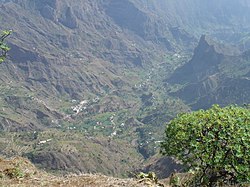
Xoxo is a settlement in the northeastern part of the island of Santo Antão in Cape Verde. It is situated 5 kilometres (3.1 mi) south of Ribeira Grande and 13 kilometres (8.1 mi) north of the island capital Porto Novo. The settlement lies in Cova-Paul-Ribeira da Torre Natural Park. The Ribeira da Torre flows through the settlement. The only road to Xoxo goes from Ribeira Grande through the Ribeira da Torre valley.
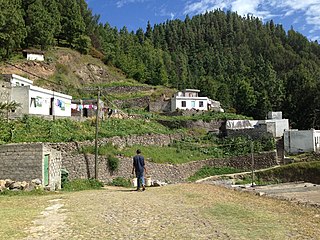
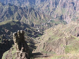
Pico da Cruz is a settlement in the northeastern part of the island of Santo Antão, Cape Verde. In 2010 its population was 138. It is situated 6 km southwest of Pombas and 10 km northeast of the island capital Porto Novo. Its elevation is about 1,400 meters. The village is named after the nearby mountain Pico da Cruz. It lies in the Cova-Paul-Ribeira da Torre Natural Park.
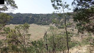
Cova is a volcanic caldera in the eastcentral part of the island of Santo Antão in Cape Verde. It is situated at the southwestern end of the municipality of Paul. Its lowest point is 1,166 meters, and the highest point of the crater rim is about 1,500 m. The diameter of the caldera is about 1.0 km. It forms a part of Cova-Paul-Ribeira da Torre Natural Park. The Cova formation dates from between 1.4 million and 700,000 years ago.
Figueira Muita is a settlement in the northern part of the island of Santiago, Cape Verde. It is part of the municipality of Tarrafal. In 2010 its population was 160. It is located about 2 km south of Ribeira da Prata and 8 km south of Tarrafal.
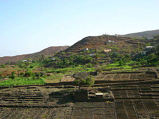
Figueiral is a settlement in the eastern part of the island of Santo Antão, Cape Verde. In 2010 its population was 591. It is part of the municipality of Paul. It is situated in the valley of the Ribeira do Figueiral, a tributary of the Ribeira do Paul, 2 km southwest of Eito and 3 km southwest of Pombas.