Ribeira, Portuguese and Galician for stream or riverside, may refer to the following places:

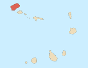
Santo Antão is the westernmost island of Cape Verde. At 785 km2 (303 sq mi), it is the largest of the Barlavento Islands group, and the second largest island of Cape Verde. The nearest island is São Vicente to the southeast, separated by the sea channel Canal de São Vicente. Its population was 38,200 in mid 2019, making it the fourth most populous island of Cape Verde after Santiago, São Vicente and Sal. Its largest city is Porto Novo located on the southern coast.

Ponta do Sol is the northernmost city on the island of Santo Antão and Cape Verde. It is situated on the coast, 4 km northwest of Ribeira Grande and 20 km north of the island capital Porto Novo. It is the seat of Ribeira Grande municipality.
The Santo Antão North Premier Division is a regional championship played in Ribeira Grande and Paul, Santo Antão Island, Cape Verde. It is organized by the Santo Antão North Regional Football Association. The winner of the championship plays in Cape Verdean football Championships of each season. The league was formed in 1997 and continued to play with the Santo Antão Island League until the breakup into the north and south zones in 2002.

Corda is a settlement in the island of Santo Antão, Cape Verde. It is part of the municipality Ribeira Grande. It is situated in the mountainous interior of the island at about 1,000 meters elevation, 13 km north of the island capital Porto Novo. Corda consists of several villages, including Chã de Corda and Esponjeiro. The national road from Porto Novo to Ribeira Grande (EN1-SA01) passes through Corda. The crater of Cova lies 4 km to the southeast. Corda lies in the Cova-Paul-Ribeira da Torre Natural Park.

Nossa Senhora do Rosário is a freguesia of Cape Verde. It covers the eastern part of the municipality of Ribeira Grande, on the island of Santo Antão.
Lombo Santa is a settlement in the northern part of the island of Santo Antão, Cape Verde. It is situated in the upper valley of the river Ribeira Grande, 10 km southwest of the town Ribeira Grande and 16 km northwest of the island capital Porto Novo.
Tarrafal de Monte Trigo is a settlement in the southwestern part of the island of Santo Antão, Cape Verde. In 2010 its population was 841. It is situated on the coast, 27 km west of the island capital Porto Novo. The settlement was mentioned as Terrafal in the 1747 map by Jacques-Nicolas Bellin.

Pombas is a city in the northeastern part of the island of Santo Antão, Cape Verde. It is the seat of the municipality Paul. It is situated on the coast, at the mouth of the Ribeira do Paul, 7 km (4.3 mi) southeast of Ribeira Grande and 15 km (9.3 mi) north of the island capital Porto Novo. The national roads EN1-SA02 and EN1-SA03 connect Pombas with Ribeira Grande and Porto Novo, respectively. Pombas was elevated from town to city in 2010.
Lombo Branco is a settlement in the northeastern part of the island of Santo Antão, Cape Verde. It is situated 4 km southeast of Ribeira Grande and 17 km north of the island capital Porto Novo.
Beira-Mar Desportivo Clube or Clube Desportivo Beira-Mar is a football club that had played in the Premier division and plays in the Santo Antão Island League South Zone in Cape Verde. It is based in the town of Ribeira Grande in the northwestern part of the island of Santo Antão.
Rosariense Clube da Ribeira Grande, also as Rosariense Desportivo Clube, short or conventional form: Rosariense Clube is a football club that had played in the Premier division and plays in the Santo Antão Island League South Zone in Cape Verde. It is based in the town of Ribeira Grande in the northeastern part of the island of Santo Antão. Its current chairman is Orlando de Jesus Delgado who is since September 12, 2015
Clube Desportivo Sinagoga, also known as Sinagoga Futebol Clube is a football club that had played in the Premier division and plays in the Santo Antão Island League South Zone in Cape Verde. It is based in the village of Sinagoga in the northeastern part of the island of Santo Antão. Its current manager is Cadoram since November 2016. The stadium is located in the northern part of the island, next to the mountains in Ponta do Sol at Estádio João Serra.

Ribeira Grande is the largest town of the Ribeira Grande Municipality on the island of Santo Antão, Cape Verde. It has become a city in 2010. In 2010 its population was 2,564. It is situated in the northeastern part of the island, near the outflow of the river Ribeira Grande and its tributary Ribeira da Torre into the Atlantic Ocean. Neighborhoods include Tarrafal, Rua de Agua, Rua d'Horta and Penha de França.

Porto Novo is a city in the island of Santo Antão, in Cape Verde. It is the seat of the Porto Novo municipality. At the 2010 census, the town had 9,310 inhabitants, which makes it the most populous settlement of the island.
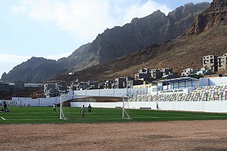
Estádio João Serra is a multi-use stadium in Santo Antão, Cape Verde. Its location is south of the urban area. It is near the foot of the island's northern mountains and is nearby a newly built urban area. The stadium is operated by the Santo Antão North Regional Football Association (ARFSAN) and has its offices there. It is currently used mostly for football matches and is the home stadium of Solpontense as well as Irmãos Unidos, other football clubs from the north of the island not based in the town play at the stadium including Paulense from Paul and Sinagoga located between Ribeira Grande and Paul and other parts of the two northern municipalities. The stadium holds 2,000 people. It is named for João Serra, its size is 100x65 m and its grass is artificial.

Xoxo is a settlement in the northeastern part of the island of Santo Antão in Cape Verde. It is situated 5 kilometres (3.1 mi) south of Ribeira Grande and 13 kilometres (8.1 mi) north of the island capital Porto Novo. The settlement lies in Cova-Paul-Ribeira da Torre Natural Park. The Ribeira da Torre flows through the settlement. The only road to Xoxo goes from Ribeira Grande through the Ribeira da Torre valley.
Chã de Pedras is a settlement in the northcentral part of the island of Santo Antão, Cape Verde. In 2010 its population was 1,266. It is situated about 5 km south of Coculi, 8 km southeast of the city Ribeira Grande and 12 km northwest of the island capital Porto Novo. It consists of 21 localities in the valley of the Ribeira de Chã de Pedras, a right tributary of the Ribeira Grande. The elevation of the largest village, Pia de Cima, is about 430 metres.
The Santo Antão North Cup is a regional football (soccer) cup competition played during the season in the northern part of Santo Antão Island (consisting of the municipalities of Paul and Ribeira Grande, Cape Verde. The cup tournament is organized by the Santo Antão North Regional Football Association. The winner participates in the Santo Antão North Super Cup. For several times, the winner participated in the Cape Verdean Cup. The first entrant was in 2007 which was Rosariense and their recent was in 2012 and was Paulense. Since 2013, there were no entrants to the national cup due to financial concerns. From the 2015 edition, the winner qualifies into the Santo Antão Super Cup, a single island cup competition challenging a club from the north.
The Santo Antão North (Zone) Opening Tournament was an opening tournament. played during the season in the northern part of Santo Antão Island (consisting of the municipalities of Paul and Ribeira Grande, Cape Verde. The opening tournament was organized by the Santo Antão North Regional Football Association.