Santo André (Porto Novo)

Last updated
Santo André
Civil parish
Cape Verde location map.svg
Red pog.svg
Santo André
Coordinates: 17°05′N25°17′W / 17.08°N 25.28°W / 17.08; -25.28 Coordinates: 17°05′N25°17′W / 17.08°N 25.28°W / 17.08; -25.28
Country Cape Verde
Island Santo Antão
Municipality Porto Novo
Population (2010) [1]
  Total 3,441

Santo André is a freguesia (civil parish) of Cape Verde. It covers the smaller, northwestern part of the municipality of Porto Novo, on the island of Santo Antão.

Cape Verde Country comprising ten islands off the Northwest coast of Africa

Cape Verde or Cabo Verde, officially the Republic of Cabo Verde, is an island country spanning an archipelago of 10 volcanic islands in the central Atlantic Ocean. It forms part of the Macaronesia ecoregion, along with the Azores, Canary Islands, Madeira, and the Savage Isles. In ancient times these islands were referred to as "the Islands of the Blessed" or the "Fortunate Isles". Located 570 kilometres (350 mi) west of the Cape Verde Peninsula off the coast of Northwest Africa, the islands cover a combined area of slightly over 4,000 square kilometres (1,500 sq mi).

Porto Novo, Cape Verde (municipality) Municipality in Santo Antão, Cape Verde

Porto Novo is a concelho (municipality) of Cape Verde. Situated in the southern part of the island of Santo Antão, it covers 72% of the island area, and is home to 41% of its population. Its population at the 2010 census was 18,028. Its capital is the town Porto Novo. Its highest point, which is also the highest point of the entire island, is Tope de Coroa, elevation 1,979 metres. The municipality of Porto Novo was created in 1962 when the parishes of São João Baptista and Santo André were separated from the older Municipality of Paul.

Santo Antão, Cape Verde Westernmost and largest of the Barlavento islands of Cape Verde

Santo Antão is the westernmost island of Cape Verde. At 779 km2 (301 sq mi), it is the largest of the Barlavento Islands group, and the second largest island of Cape Verde. The nearest island is São Vicente to the southeast, separated by the sea channel Canal de São Vicente. Its population was 40,547 in 2015, making it the third most populous island of Cape Verde after Santiago and São Vicente. Its largest city is Porto Novo on the south coast.

Settlements

The freguesia consists of the following settlements (population at the 2010 census):

Alto Mira Settlement in Santo Antão, Cape Verde

Alto Mira is a settlement in the northwestern part of the island of Santo Antão, Cape Verde. It is situated 4 km southeast of Ribeira da Cruz and 18 km northwest of the island capital Porto Novo. Its population was 1,003 at the 2010 census. The Moroços Natural Park lies east of the settlement. The settlement is divided into several localities, including Chã Bonita, Chã Daurinca, Chã de Dragoeiro, Dominguinhas, Faial and Lombo Gorado. The Ribeira Alto Mira flows through the settlement.

Monte Trigo Settlement in Santo Antão, Cape Verde

Monte Trigo is the westernmost settlement on the island of Santo Antão, Cape Verde. It is situated on the coast, at the foot of the Tope de Coroa, the highest mountain of the island. It is 28 km west of the island capital Porto Novo. In 2010 its population was 274. About 5 km to the northwest is Ponta do Chão de Mangrade, the westernmost point of all Africa.

Ribeira da Cruz Settlement in Santo Antão, Cape Verde

Ribeira da Cruz is a settlement in the northwestern part of the island of Santo Antão, Cape Verde. Situated 22 km northwest of the island capital Porto Novo, it is part of the parish of Santo André, in the municipality of Porto Novo. It had 421 inhabitants at the 2010 census.

Related Research Articles

Paul, Cape Verde Municipality in Santo Antão, Cape Verde

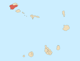
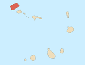
Paul is a concelho (municipality) of Cape Verde. Situated in the northeastern part of the island of Santo Antão, it covers 7% of the island area, and is home to 16% of its population. Its seat is the town Pombas.

Tarrafal, Cape Verde (municipality) Municipality in Santiago, Cape Verde

Tarrafal is a concelho (municipality) of Cape Verde. It is situated in the northern part of the island of Santiago. Its seat is the town Tarrafal. Its population was 18,565 at the 2010 census, and its area is 120.8 km2.

São Miguel, Cape Verde Municipality in Santiago, Cape Verde

São Miguel is a concelho (municipality) of Cape Verde. It is situated in the northeastern part of the island of Santiago. Its seat is the city Calheta de São Miguel. Its population was 15,648 at the 2010 census, and its area is 77.4 km2. The municipality was created in 1996, when a parish of the older Municipality of Tarrafal was separated to become the Municipality of São Miguel.

Santa Catarina, Cape Verde Municipality in Santiago, Cape Verde

Santa Catarina is a concelho (municipality) of Cape Verde. It is situated in the western part of the island of Santiago. Its seat is the city of Assomada. Its population was 45,920 in 2017 (estimate). Its area is 242.6 km2.

Santa Cruz, Cape Verde Municipality in Santiago, Cape Verde

Santa Cruz is a concelho (municipality) of Cape Verde. It is situated in the eastern part of the island of Santiago. Its seat is the city Pedra Badejo. Its population was 26,617 at the 2010 census, and its area is 112.2 km2.

São Lourenço dos Órgãos, Cape Verde Municipality in Santiago, Cape Verde

São Lourenço dos Órgãos is a concelho (municipality) of Cape Verde. It is situated in the mountainous central part of the island of Santiago. Its seat is the city João Teves. Its population was 7,388 at the 2010 census, and its area is 36.9 km2. The municipality is bordered by Santa Cruz to the northeast, São Domingos to the south, Ribeira Grande de Santiago to the southwest and São Salvador do Mundo to the northwest. Pico de Antónia, the island's highest mountain, straddles the borders of São Lourenço dos Órgãos, São Salvador do Mundo and Ribeira Grande de Santiago.

Santa Catarina do Fogo, Cape Verde Municipality in Fogo, Cape Verde

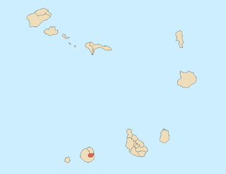
Santa Catarina do Fogo is a concelho (municipality) of Cape Verde. Situated in the southeastern part of the island of Fogo, it covers 32% of the island area, and is home to 14% of its population. Its seat is the city Cova Figueira. The Municipality of Santa Catarina do Fogo was created in 2005; before 2005, it was a parish of the Municipality of São Filipe.

São Salvador do Mundo, Cape Verde Municipality in Santiago, Cape Verde

São Salvador do Mundo is a concelho (municipality) of Cape Verde. It is situated in the central part of the island of Santiago. Its seat is the city Picos. Its population was 8,677 at the 2010 census, and its area is 26.5 km2, making it the smallest municipality of Cape Verde. The municipality borders Santa Cruz to the northeast, São Lourenço dos Órgãos to the southeast, Ribeira Grande de Santiago to the southwest and Santa Catarina to the northwest.

Nossa Senhora da Lapa (Ribeira Brava) Civil parish in São Nicolau, Cape Verde

Nossa Senhora da Lapa is a freguesia of Cape Verde. It covers the smaller northwestern part of the municipality of Ribeira Brava, on the island of São Nicolau.

São Lourenço (São Filipe) Civil parish in Fogo, Cape Verde

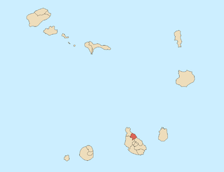
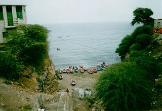
São Lourenço is a freguesia of Cape Verde. It covers the northern part of the municipality of São Filipe, on the island of Fogo. The parish has an area of 96 km². It is also a religious parish, its religious celebration is on August 10, day of Saint Lawrence.

Nossa Senhora da Luz (São Domingos) Civil parish in Santiago, Cape Verde

Nossa Senhora da Luz is a freguesia of Cape Verde. It covers the eastern part of the municipality of São Domingos, on the island of Santiago.

Santíssimo Nome de Jesus Civil parish in Santiago, Cape Verde

Santíssimo Nome de Jesus is a freguesia of Cape Verde. It covers the eastern part of the municipality of Ribeira Grande de Santiago, on the island of Santiago.

São João Baptista (Ribeira Grande de Santiago) Civil parish in Santiago, Cape Verde

São João Baptista is a freguesia of Cape Verde. It covers the western part of the municipality of Ribeira Grande de Santiago, on the island of Santiago.

São Nicolau Tolentino (São Domingos) Civil parish in Santiago, Cape Verde

São Nicolau Tolentino is a freguesia of Cape Verde. It covers the western part of the municipality of São Domingos, on the island of Santiago.

Nossa Senhora do Livramento, Cape Verde Civil parish in Santo Antão, Cape Verde

Nossa Senhora do Livramento is a freguesia of Cape Verde. It covers the northern part of the municipality of Ribeira Grande, on the island of Santo Antão.

Nossa Senhora do Rosário (Ribeira Grande) Civil parish in Santo Antão, Cape Verde

Nossa Senhora do Rosário is a freguesia of Cape Verde. It covers the eastern part of the municipality of Ribeira Grande, on the island of Santo Antão.

Santo Crucifixo Civil parish in Santo Antão, Cape Verde

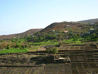
Santo Crucifixo is a freguesia of Cape Verde. It covers the southern part of the municipality of Ribeira Grande, on the island of Santo Antão. The seat of the parish is Coculi. The parish covers much of the Ribeira Grande valley.

São João Baptista (Santo Antão) Civil parish in Santo Antão, Cape Verde

São João Baptista is a freguesia of Cape Verde. It covers the larger, southern part of the municipality of Porto Novo, on the island of Santo Antão.

São Pedro Apóstolo Civil parish in Santo Antão, Cape Verde

São Pedro Apóstolo is a freguesia of Cape Verde. It covers the western part of the municipality of Ribeira Grande, on the island of Santo Antão.

Nossa Senhora do Rosário (Ribeira Brava) Civil parish in São Nicolau, Cape Verde

Nossa Senhora do Rosário is a freguesia of Cape Verde. It covers the larger eastern part of the municipality of Ribeira Brava, on the island of São Nicolau.

References