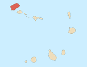
Santo Antão is the westernmost island of Cape Verde. At 785 km2 (303 sq mi), it is the largest of the Barlavento Islands group, and the second largest island of Cape Verde. The nearest island is São Vicente to the southeast, separated by the sea channel Canal de São Vicente. Its population was 38,200 in mid 2019, making it the fourth most populous island of Cape Verde after Santiago, São Vicente and Sal. Its largest city is Porto Novo located on the southern coast.

Santiago is the largest island of Cape Verde, its most important agricultural centre and home to half the nation's population. Part of the Sotavento Islands, it lies between the islands of Maio and Fogo. It was the first of the islands to be settled: the town of Ribeira Grande was founded in 1462. Santiago is home to the nation's capital city of Praia.

Paul is a concelho (municipality) of Cape Verde. Situated in the northeastern part of the island of Santo Antão, it covers 7% of the island area, and is home to 16% of its population. Its seat is the town Pombas.

Ribeira Grande de Santiago is a concelho (municipality) of Cape Verde. It is situated in the southwestern part of the island of Santiago. Its seat is the city Cidade Velha. Its population was 8,325 at the 2010 census, and its area is 137.3 km2.

Ponta do Sol is the northernmost city on the island of Santo Antão and Cape Verde. It is situated on the coast, 4 km northwest of Ribeira Grande and 20 km north of the island capital Porto Novo. It is the seat of Ribeira Grande municipality.

Ribeira da Barca is a town in the municipality of Santa Catarina, on the island of Santiago, Cape Verde. In 2010 its population was 2,317. It is situated on the west coast, at the mouth of the stream Ribeira da Barca, 11 km northwest of Assomada. The settlement was mentioned as "Rivera das Baras" in the 1747 map by Jacques-Nicolas Bellin.
Santana is a settlement in the southern part of the island of Santiago, Cape Verde. It is part of the municipality of Ribeira Grande de Santiago. It is situated 2 km east of Belém and 9 km northwest of Cidade Velha.
Nossa Senhora do Rosário is a freguesia of Cape Verde. It covers the eastern part of the municipality of Ribeira Grande, on the island of Santo Antão.
Santo Crucifixo is a freguesia of Cape Verde. It covers the southern part of the municipality of Ribeira Grande, on the island of Santo Antão. The seat of the parish is Coculi. The parish covers much of the Ribeira Grande valley.
Lombo Santa is a settlement in the northern part of the island of Santo Antão, Cape Verde. It is situated in the upper valley of the river Ribeira Grande, 10 km southwest of the town Ribeira Grande and 16 km northwest of the island capital Porto Novo.
São Pedro Apóstolo is a freguesia of Cape Verde. It covers the western part of the municipality of Ribeira Grande, on the island of Santo Antão.

Pombas is a city in the northeastern part of the island of Santo Antão, Cape Verde. It is the seat of the municipality Paul. It is situated on the coast, at the mouth of the Ribeira do Paul, 7 km (4.3 mi) southeast of Ribeira Grande and 15 km (9.3 mi) north of the island capital Porto Novo. The national roads EN1-SA02 and EN1-SA03 connect Pombas with Ribeira Grande and Porto Novo, respectively. Pombas was elevated from town to city in 2010.

Chã de Igreja is a town in the northern part of the island of Santo Antão, Cape Verde. It is situated near the north coast of the island, in the valley of the river Ribeira da Garça, 19 km northwest of the island capital Porto Novo. In 2010 its population was 672. The nature reserve Cruzinha, which includes the small seaside village Cruzinha da Garça, stretches northeast of Chã de Igreja along the coast.
Fajã de Baixo is a town in the northern part of the island of São Nicolau, Cape Verde. It is situated 2 km south of Estância de Brás and 5 km northwest of Ribeira Brava.
Praia is a concelho (municipality) of Cape Verde. It is situated in the southern part of the island of Santiago. Its seat is the city Praia, the capital of Cape Verde. Its area is 120.6 km2 (46.6 sq mi), and its population was 131,719 at the 2010 census. The municipality consists of one freguesia, Nossa Senhora da Graça. The city hall is located in the Platô part of the city.

Ribeira Grande is the largest town of the Ribeira Grande Municipality on the island of Santo Antão, Cape Verde. It has become a city in 2010. In 2010 its population was 2,564. It is situated in the northeastern part of the island, near the outflow of the river Ribeira Grande and its tributary Ribeira da Torre into the Atlantic Ocean. Neighborhoods include Tarrafal, Rua de Agua, Rua d'Horta and Penha de França.

Ribeira Brava is a city on the island of São Nicolau, Cape Verde. It is the seat of the Ribeira Brava Municipality. Its population was 1,936 at the 2010 census. The town is situated in the valley of the river Ribeira Brava, east of the main mountain range of the island. The name of the river is Portuguese for "rough stream", referring to the violent behaviour of the river during rains. The city has a colonial look with Portuguese style buildings, parks and gardens, small winding streets, and steep hills.
Salineiro is a village in the southern part of the island of Santiago, Cape Verde. It is part of the municipality of Ribeira Grande de Santiago. In 2010 its population was 1,113. It is located on the western edge of the Ribeira Grande gorge, 2.5 km north of Cidade Velha and 11 km west of the capital Praia.

Calabaceira is a village in the southern part of the island of Santiago, Cape Verde. It is part of the municipality Ribeira Grande de Santiago. In 2010 its population was 366. It is located on the eastern edge of the Ribeira Grande gorge, 2 km northeast of Cidade Velha and 10 km west of the capital Praia.
Chã de Pedras is a settlement in the northcentral part of the island of Santo Antão, Cape Verde. In 2010 its population was 1,266. It is situated about 5 km south of Coculi, 8 km southeast of the city Ribeira Grande and 12 km northwest of the island capital Porto Novo. It consists of 21 localities in the valley of the Ribeira de Chã de Pedras, a right tributary of the Ribeira Grande. The elevation of the largest village, Pia de Cima, is about 430 metres.