Ribeira, Portuguese and Galician for stream or riverside, may refer to the following places:

Paul is a concelho (municipality) of Cape Verde. Situated in the northeastern part of the island of Santo Antão, it covers 7% of the island area, and is home to 16% of its population. Its seat is the town Pombas.

Ponta do Sol is the northernmost city on the island of Santo Antão and Cape Verde. It is situated on the coast, 4 km northwest of Ribeira Grande and 20 km north of the island capital Porto Novo. It is the seat of Ribeira Grande municipality.

Ribeira da Barca is a town in the municipality of Santa Catarina, on the island of Santiago, Cape Verde. In 2010 its population was 2,317. It is situated on the west coast, at the mouth of the stream Ribeira da Barca, 11 km northwest of Assomada. The settlement was mentioned as "Rivera das Baras" in the 1747 map by Jacques-Nicolas Bellin.

Janela is a settlement in the eastern part of the island of Santo Antão, Cape Verde. It is situated on the Atlantic coast, 4 km southeast of Pombas and 14 km northeast of the island capital Porto Novo The central village, Pontinha, lies on a rocky peninsula. More villages are situated in the valley of the river Ribeira da Janela. The national road from Porto Novo to Pombas (EN1-SA03) passes through Janela.

Ribeira da Garça is a river in the northern part of the island of Santo Antão in Cape Verde. Its source is on the north side of the eastern plateau of the island, northeast of Pico Moroços. It flows north through the settlements of Garça de Cima and Chã de Igreja, in the western part of the municipality of Ribeira Grande. It flows into the Atlantic Ocean near Chã de Igreja.

Ribeira do Paul is a seasonal stream that flows in the northeastern part of the island of Santo Antão in Cape Verde. The stream flows from southwest to northeast. The upper part of the valley belongs to Cova-Paul-Ribeira da Torre Natural Park.
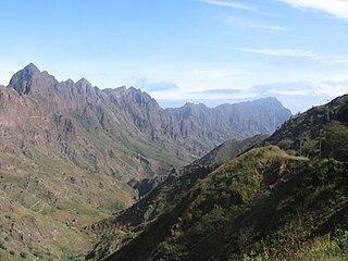
Ribeira Grande is a stream in the northeastern part of the island of Santo Antão in Cape Verde. The stream flows from west-southwest to east-northeast, through a steep and narrow gorge. The river begins near Lombo Santa, passes through Boca de Ambas Ribeiras, Boca de Coruja and Coculi, and flows into the Atlantic Ocean at the town of Ribeira Grande. Its most important tributaries are the Ribeira de Chã das Pedras, and the Ribeira da Torre, that joins the Ribeira Grande in the town Ribeira Grande.
Solpontense Futebol Clube is a football club that currently plays in the Second Division of the Santo Antão Island League South Zone in Cape Verde. It is based in the town of Ponta do Sol in the northern part of the island of Santo Antão and being the country's northernmost football club. Its current manager is João Lopes Rodrígues.

Ribeira do Calhau is a stream in the eastern part of the island of São Vicente in Cape Verde. It begins in the hills southeast of the island capital Mindelo, flows towards the east and empties into the Atlantic Ocean, at the village Calhau. The settlement Ribeira de Calhau, which comprises the villages Madeiral, Ribeira de Calhau and Calhau, takes its name from this stream.

Cape Verde was a colony of the Portuguese Empire from the initial settlement of the Cape Verde Islands in 1462 until the independence of Cape Verde in 1975.

Ribeira da Torre is a torrential stream in the northeastern part of the island of Santo Antão in Cape Verde. Its source is in the mountains north of the Cova crater, near the locality Rabo Curto. It flows to the north through the settlements Xoxo, Fajã Domingas Benta and Lugar de Guene. In the city Ribeira Grande it flows into the river Ribeira Grande, just upstream of its outflow into the Atlantic Ocean. Its upper valley is part of the protected area Cova-Paul-Ribeira da Torre Natural Park. There is small-scale agriculture in the valley, producing sugar cane, coffee, yam, banana, papaya and mango.

Ribeira da Trindade is a stream in the southern part of the island of Santiago in Cape Verde. It is the most important river of Praia, the capital of Cape Verde. Its basin area is 24.9 km2 (9.6 sq mi). The stream flows northwest to southeast and is about 15 km in length. Its source is in the municipality of São Domingos, near the settlement Achada Mitra. It flows through the city of Praia and discharges into the Praia Harbour, near the city centre.

Ribeira Grande de Santiago is a stream in the southern part of the island of Santiago in Cape Verde. In its upper part it is called Ribeira Cadacina. Its source is in the central mountain range of the island, near Monte Tchota, west of Rui Vaz, in the municipality of São Domingos. It flows towards the south, and joins the Atlantic Ocean in Cidade Velha. Villages along its course are Achada Loura, Salineiro and Calabaceira. A reservoir for irrigation was built near Salineiro in 2013.

Ribeira Seca is the largest stream of the island of Santiago in Cape Verde. It is 18 km (11 mi) long and its basin area is 71.5 km2 (27.6 sq mi). Located in the eastern part of the island, it flows through the municipalities of São Lourenço dos Órgãos and Santa Cruz. Its source is near the highest point of the island, Pico de Antónia, from where it flows to the east to João Teves. It turns to the northeast and flows into the Atlantic Ocean at Achada Fazenda, 2 km southeast of Pedra Badejo. It is called Ribeira de Pico da Antónia in its uppermost part, and Ribeira de Lage near João Teves.


