Santo Antão is the westernmost island of Cape Verde. At 779 km2 (301 sq mi), it is the largest of the Barlavento Islands group, and the second largest island of Cape Verde. The nearest island is São Vicente to the southeast, separated by the sea channel Canal de São Vicente. Its population was 40,547 in 2015, making it the third most populous island of Cape Verde after Santiago and São Vicente. Its largest city is Porto Novo on the south coast.
Cape Verde or Cabo Verde, officially the Republic of Cabo Verde, is an island country spanning an archipelago of 10 volcanic islands in the central Atlantic Ocean. It forms part of the Macaronesia ecoregion, along with the Azores, Canary Islands, Madeira, and the Savage Isles. In ancient times these islands were referred to as "the Islands of the Blessed" or the "Fortunate Isles". Located 570 kilometres (350 mi) west of the Cape Verde Peninsula off the coast of Northwest Africa, the islands cover a combined area of slightly over 4,000 square kilometres (1,500 sq mi).
Several rock formations were formed including the old volcanic complex during the Tortonian era, the Bordeira rock group was formed around 2 to 1 million years ago, the Cova group was formed around 1.4 million to 700,000 years ago. Later eruptions took place on the island and made the Proto-Coroa formation around 400,000 years ago,[1] the Agua Nova group around 300,000 years ago, the last eruption one the island was around 200,000 years ago and was a Plinian eruption, it formed the Coroa and Young Tarrafal rock formations. Around 100,000 years ago, the Lagoa rock formation formed[1]
The Tortonian is in the geologic timescale an age or stage of the late Miocene that spans the time between 11.608 ± 0.005 Ma and 7.246 ± 0.005 Ma. It follows the Serravallian and is followed by the Messinian.
Its reptiles and insects came to the island along with its flora, they probably did not rafted itself from the African mainland but the most probable was from the nearby island of São Vicente during the time of the Last Ice Age.
The sea levels dropped during the Ice Age and was larger and compromised an estimate size of 800 km2 of land, it separated São Vicente between 500 meters (1500 feet) to 1 kilometer. Flooding took place and the São Vicente Channel was widened up to 10km about 8,000 to 6,000 years ago and later to its current 12km length. Also up to 5,000 and 4,000 BC, the island's tallest summit Topo da Coroa's elevation was at 2,000 meters (around 6,000 feet).
São Vicente is one of the Barlavento Islands, the northern group within the Cape Verde archipelago in the Atlantic Ocean, off the west African coast. It is located between the islands of Santo Antão and Santa Luzia, with the Canal de São Vicente separating it from Santo Antão.
The Canal de São Vicente is a strait of the Atlantic Ocean separating the islands of Santo Antão and São Vicente, Cape Verde. At its narrowest point, it is 11 km (7 mi) wide. The ferry route between the ports of Porto Novo on Santo Antão and Mindelo on São Vicente crosses the canal. The channel begins in São Vicente's northwesternmost cape near Monte Cara up to the headland Ponta de João d'Évora in the northeast.
Colonial and provincial Santo Antão Island
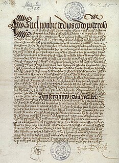
The island was discovered by Diogo Afonso on Saint Anthony's Day on January 17, it was discovered after São Nicolau and before São Vicente and Santa Luzia. It did not give its current name until around the 16th century. Before it was inhabited, the forests dominated most of the north and barren landscape in the south and west.
Diogo Afonso was a Portuguese explorer.
In 1494, the Treaty of Tordesillas was put on June 7, 1494 between ortugal and the Kingdom of Castile that determined the division of the areas of influences of the Iberian countries it marked the line of discovered and then undiscovered lands with an imaginary line located 370 leagues (1,770km) west of the island, marked at the island's westernmost point west of present-day Monte Trigo.
The Treaty of Tordesillas, signed at Tordesillas in Spain on June 7, 1494, and authenticated at Setúbal, Portugal, divided the newly discovered lands outside Europe between the Portuguese Empire and the Crown of Castile, along a meridian 370 leagues west of the Cape Verde islands, off the west coast of Africa. This line of demarcation was about halfway between the Cape Verde islands and the islands entered by Christopher Columbus on his first voyage, named in the treaty as Cipangu and Antilia.
Monte Trigo is the westernmost settlement on the island of Santo Antão, Cape Verde. It is situated on the coast, at the foot of the Tope de Coroa, the highest mountain of the island. It is 28 km west of the island capital Porto Novo. In 2010 its population was 274. About 5 km to the northwest is Ponta do Chão de Mangrade, the westernmost point of all Africa.
The island was first settled in 1548 probably around early January and the first settlement could be Fontainhas where the number of springs were located or Ponta do Sol, the first settlers of Ponta do Sol came from the Madeira Islands and named that settlement after it. Gonçalo de Sousa became its only captain of the island on January 13. African slaves from the mainland including the Bijagós Archipelago (then commonly called Bissagos) and the nearby island of Santiago were brought to the island and were also its settlers. More people specially those from Northern Portugal e and slaves inhabited the island in the mid 17th century and inhabited the area around today's Ribeira Grande, a settlement would be founded there. Later, some Jewish people inhabited the island and the largest population was in the settlement of Sinagoga where a synagogue would be located. Wine and coffee became the most important exports of the island. In 1724, a year of British occupation occurred, not long after, the Portuguese ruled it again for another 250 years. In 1732, RIbeira Grande was elevated to a town and became island capital, before Mindelo was founded, it was the main location of northwestern Cape Verde. Later other settlements including Carvoeiros (now Porto Novo), Ribeira das Pratas and Tarrafal de Monte Trigo were founded.
Ribeira Grande is the largest town of the Ribeira Grande Municipality on the island of Santo Antão, Cape Verde. It has become a city in 2010. In 2010 its population was 2,564. It is situated in the northeastern part of the island, near the outflow of the river Ribeira Grande and its tributary Ribeira da Torre into the Atlantic Ocean. Neighborhoods include Tarrafal, Rua de Agua, Rua d'Horta and Penha de França.
Sinagoga is a settlement in the northeastern part of the island of Santo Antão, Cape Verde. It is situated on the coast, 4 kilometers east of Ribeira Grande and 18 km north-northeast of the island capital Porto Novo. It is situated on the national road connecting Ribeira Grande and Pombas (EN1-SA02).
Porto Novo is a city in the island of Santo Antão, in Cape Verde. It is the seat of the Porto Novo municipality. At the 2010 census, the town had 9,310 inhabitants, which makes it the most populous settlement of the island.
As Mindelo on the opposite island was flourishing, as yellow fever struck that city in 1861, some families moved to the nearby island to restore Mindelo's population. Even though the island's municipality included that island until the late 19th century and the municipality just included the main island afterwards, for some times, Paul was a separate municipality until the late 19th century and were one of two on the island. Small rebellions and insurrection took place on the island between 1886 and 1894 which was crushed by colonial authorities.[2] Migration to the neighboring island continued for several more years. At the start of the 20th century, famine devastated the island along with all of Cape Verde with the minimal exception of most of Sal, its population mainly emigrated to Europe which intensified during the mid 20th century. Luís Romano de Madeira Melo later became the famous poet from the island, aligned with the independence movement, common throughout Cape Verde at the time, he was later captured by PIDE and exiled until the island's independence. Gabriel Mariano also wrote works related to nationalism including Restoration, Cultural Supplement and Boletim de Cabo Verde, he was later deported to Mozambique Another person Luís de Matos Monteiro da Fonseca, member of the PAIGC spend his times at Tarrafal Camp before independence, later he became a diplomat.
Access to other parts of the island were done by boats. Its dirt tracks and pathways with other parts were narrowly accessible and treacherous. It led to a construction of a highway through high elevations with other parts of the island, Estrada da Corda was opened connecting Ribeira Grande and Carvoeiros through the Cova crater in the mid 1960s which gained access with the south and the west easier, it was the main access for more than four decades. Also in the same time in Ponta do Sol, Santo Antão Airport opened, after independence it was named after Agostinho Neto At the same time, the island's main port was transferred to Carvoeiros and the town's name became Porto Novo after its new port. In 1971, the island municipality was dissolved and Porto Novo and Ribeira Grande municipalities were formed and the municipality of Paul was recreated, they were not fully created until 1990.
Modern Santo Antão Island
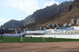
The economic growth was not as good as the neighboring island, the population of São Vicente would become more populous in the mid 1980s. Football (soccer) was rising in popularity in the island, in 1981, three clubs were created. Other sports became popular later on in the 1990s. The Santo Antão Regional Championships were established in 1995, it had the North and South Zones in 1997 and an upper level, it resumed the single island championship until 2002 when it broke up into the current north and south zones. Other sports including basketball, futsal, volleyball and athletics unlike Santiago continues its single island competitions. In recent history of football, in December 2015, the first single super cup competition were held and later in January 2016, the single cup competition took place. Its opening tournaments were dissolved and the single and divided cup and super cup competitions continues to take place together.
The island's airport were difficult to access, fog was and dangerous as high winds were common in that area and fog was dominant some times. After the plane crash that occurred on the mountain on Santo Antão, a short flight from the nearby airport, it led to the closure of the airport in the late 2000s, its last operation was done on August 2012. An announcement of a new airport near Porto Novo in a new safe location, it was done in 2010,[3][4] no date of construction has announced. As Estrada da Corda seemed difficult to access with two parts of the island, in 2003, construction of Estrada Litoral running in the east through the Paul Valley (Vale de Paul) and no higher than around 150 meters in elevation started and was completed in early May 2009, it features the first two road tunnels in Cape Verde[5] and made access with the north and other parts of the island easier. The island's main port was enlarged in 2012.
Food export restrictions were implemented in the early 2000s due to the Cape Verdean milipede, a species described in 1987 and did not resumed exports until January 9, 2008.[6]
The Canto de Cagarra (Barragem de Canto de Cagarra), located in the north west of Ribeira Grande on Ribeira da Garça was completed on November 16, 2014 and became the only large dam on the island.[7]Hurricane Fred struck the island on September 1, 2015 and ruined carrot, cabbage, and tomato plantations in Alto Mira[8] and filled up the nearby dam of Canto de Cagarra.[9]
Demographics
The population growth was not as large as São Vicente, Santiago or the eastern islands. From the 1820s to 2000, the population only doubled. Today it is less populous than the nearby island of São Vicente. The dominant growth in the island is at Porto Novo.
Mindelo is a port city in the northern part of the island of São Vicente in Cape Verde. Mindelo is also the seat of the parish of Nossa Senhora da Luz, and the municipality of São Vicente. The city is home to 93% of the entire island's population. Mindelo is known for its colourful and animated carnival celebrations, with roots in Portuguese traditions.
Ribeira Grande is a municipality in the northern part of the island of São Miguel in the Portuguese Azores. The population in 2011 was 32,112, in an area of 180.15 km². The municipal seat is located in the civil parish of Matriz, with a population of about 4000 inhabitants, part of the urbanized core of what is commonly referred to as the city of Ribeira Grande.
São Nicolau is one of the Barlavento (Windward) islands of Cape Verde. It is located between the islands of Santa Luzia and Sal. Its population is 12,424 (2015), with an area of 343 km². The main towns are Ribeira Brava and Tarrafal de São Nicolau.
Ribeira Grande is a concelho (municipality) of Cape Verde. Situated in the northern part of the island of Santo Antão, it covers one fifth of the island area, and is home to nearly half of its population. Its seat is the city Ponta do Sol.
Paul is a concelho (municipality) of Cape Verde. Situated in the northeastern part of the island of Santo Antão, it covers 7% of the island area, and is home to 16% of its population. Its seat is the town Pombas.
Ponta do Sol is the northernmost city on the island of Santo Antão and Cape Verde. It is situated on the coast, 4 km northwest of Ribeira Grande and 20 km north of the island capital Porto Novo. It is the seat of Ribeira Grande municipality.
The Santo Antão Island League (South) is a regional championship played in Porto Novo, Santo Antão Island, Cape Verde. The winner of the championship plays in Cape Verdean football Championships of each season. The championship is organized by the Santo Antão South Regional Football Association. It has one of the fewest teams in the Capeverdean football or soccer ahead of Brava's and São Nicolau's. Its current head is Fernando Lima since late 2016.
Pombas is a city in the northeastern part of the island of Santo Antão, Cape Verde. It is the seat of the municipality Paul. It is situated on the coast, at the mouth of the Ribeira do Paul, 7 km (4.3 mi) southeast of Ribeira Grande and 15 km (9.3 mi) north of the island capital Porto Novo. The national roads EN1-SA02 and EN1-SA03 connect Pombas with Ribeira Grande and Porto Novo, respectively. Pombas was elevated from town to city in 2010.
Grogue, also known as grogu or grogo, is a Cape Verdean alcoholic beverage, an aguardente made from sugarcane. Its production is fundamentally artisanal, and nearly all the sugarcane is used in the production of grogue. The cane is processed in a press known as a trapiche.
The 2003 Cape Verdean Football Championship season was the 24th of the competition of the first-tier football in Cape Verde. Its started on 17 May and finished on 2 August. The tournament was organized by the Cape Verdean Football Federation. No club participated in the 2004 CAF Champions League or the 2004 CAF Winner's Cup.
The island of Santo Antão in Cape Verde in the west of the Barlavento Islands is home to several teams and clubs. The major amateur clubs are Sporting Clube do Porto Novo, Académica Porto Novo and Paulense. Its first football championship was founded in 1996 and from 2002, the association and competition are currently divided into two zones, the north and the south and includes all sports including football, basketball, volleyball and athletics and may have futsal today. Other than football, it has a single regional association covering the island.
Colá is a musical genre of Cape Verdean music
Lombo de Figueira is a settlement in the eastcentral part of the island of Santo Antão, Cape Verde, part of the municipality of Porto Novo and the parish of São João Baptista. In 2010 its population was 281. It is situated about 9 km north of the island capital Porto Novo, on the national road from Porto Novo to Ribeira Grande (EN1-SA01). Subdivisions include Água das Caldeiras and Chã de Tampa. An endemic species of butterflies, Leptotes pirithous capverti, has been found in the area.
The 2009 Cape Verdean Cup season was the 3rd competition of the regional football cup in Cape Verde. The season started on 20 July and finished with the cup final on 2 August. The cup competition was organized by the Cape Verdean Football Federation. Group A matches took place at Estádio Adérito Sena in Mindelo, São Vicente and Group B matches took place at Estádio Marcelo Leitão in Espargos. The final stage containing two semifinal matches and a final were played at Estádio da Várzea. Boavista Praia won their first of two cup title.
The 2018 Taça Nacional de Cabo Verde is the 6th edition of the Taça Nacional de Cabo Verde, the knockout football competition of Cape Verde. The competition, which is played out in a tournament between the cup winners of the nine islands, returns for the first time since 2012.
References
1 2 Holm, Paul Martin (2006). Sampling the Cape Verde Mantle Plume: Evolution of Melt Compositions on Santo Antão, Cape Verde Island. 47. p.145-18. doi:10.1093/petrology/egi071.
↑ José Silva Évora, Santo Antão no limiar do século XIX: da tensão social às insurreições populares, 1886-1894: uma perspectiva histórica, Instituto do Arquivo Histórico Nacional, Praia, 2005, 163 pages (in Portuguese)
Carlos Ferrão, Estudos sobre a Ilha de Santo Antão (Studies on the Island of Santo Antão), Imprensa Nacional, Lisbonne, 1898, 116 pages (in Portuguese)
Maria Haydée Ferreira Ferro, Subsídios para a história da Ilha de Santo Antão de Cabo Verde: 1462-1900, Instituto Caboverdiano do Livro e do Disco, Praia, 1997, 51-LX pages (in Portuguese)
This page is based on this Wikipedia article Text is available under the CC BY-SA 4.0 license; additional terms may apply. Images, videos and audio are available under their respective licenses.