Ribeira Alto Mira

Last updated
Ribeira Alto Mira
AltoMira Santo Antao.jpg
Ribeira Alto Mira along with its ravine and its village
Country Cape Verde
Physical characteristics
Main source West of Gudo de Cavaleiro,
Santo Antão
River mouth Atlantic Ocean
17°06′06″N25°12′33″W / 17.1016°N 25.2093°W / 17.1016; -25.2093 Coordinates: 17°06′06″N25°12′33″W / 17.1016°N 25.2093°W / 17.1016; -25.2093
Length 11 km (6.8 mi)

Ribeira Alto Mira (literally the High Panoramic View in Portuguese) is a stream and a small valley (or dale) in the norwestern part of the island of Santo Antão in Cape Verde.

Santo Antão, Cape Verde Westernmost and largest of the Barlavento islands of Cape Verde

Santo Antão is the westernmost island of Cape Verde. At 779 km2 (301 sq mi), it is the largest of the Barlavento Islands group, and the second largest island of Cape Verde. The nearest island is São Vicente to the southeast, separated by the sea channel Canal de São Vicente. Its population was 40,547 in 2015, making it the third most populous island of Cape Verde after Santiago and São Vicente. Its largest city is Porto Novo on the south coast.

Cape Verde Country comprising ten islands off the Northwest coast of Africa

Cape Verde or Cabo Verde, officially the Republic of Cabo Verde, is an island country spanning an archipelago of 10 volcanic islands in the central Atlantic Ocean. It forms part of the Macaronesia ecoregion, along with the Azores, Canary Islands, Madeira, and the Savage Isles. In ancient times these islands were referred to as "the Islands of the Blessed" or the "Fortunate Isles". Located 570 kilometres (350 mi) west of the Cape Verde Peninsula off the coast of Northwest Africa, the islands cover a combined area of slightly over 4,000 square kilometres (1,500 sq mi).

Contents

Description

Its source is west of Gudo de Cavaleiro at the range of the municipal boundary of Porto Novo and Ribeira Grande at the elevation of about 1500 m, where it bends from east and then northwest. It flows west then northwest starting at the elevation of about 850 m. The stream flows south, then west of the main settlement of Alto Mira and crosses through ravines as it is surrounded by mountains, dominant in many parts of the island. Pathways surround the stream. Alluvial terraces are dominant throughout the small valley in most parts within the stream. Its midway elevation is about 350 m and the stream flows east of Chã de Branquinho settlement at the elevation of about 75 m before emptying into the Atlantic Ocean. The area where it empties has a small beach and are surrounded by cliffs as to the northern part of the island.

Gudo de Cavaleiro mountain in Cape Verde

Gudo de Cavaleiro is a mountain in the middle of the island Santo Antão in Cape Verde. Its elevation is 1,810 meters. Part of the eastern plateau of Santo Antão, it lies directly south of the Moroços natural park. Nearby places are the villages Alto Mira to the west and Lagoa to the east. The mountain lies on the border of the municipalities Ribeira Grande and Porto Novo.

Porto Novo, Cape Verde (municipality) Municipality in Santo Antão, Cape Verde

Porto Novo is a concelho (municipality) of Cape Verde. Situated in the southern part of the island of Santo Antão, it covers 72% of the island area, and is home to 41% of its population. Its population at the 2010 census was 18,028. Its capital is the town Porto Novo. Its highest point, which is also the highest point of the entire island, is Tope de Coroa, elevation 1,979 metres. The municipality of Porto Novo was created in 1962 when the parishes of São João Baptista and Santo André were separated from the older Municipality of Paul.

Ribeira Grande, Cape Verde (municipality) Municipality in Santo Antão, Cape Verde

Ribeira Grande is a concelho (municipality) of Cape Verde. Situated in the northern part of the island of Santo Antão, it covers one fifth of the island area, and is home to nearly half of its population. Its seat is the city Ponta do Sol.

Hurricane Fred ruined carrot, cabbage, and tomato plantations in early September 2015 in the settlement and its valley. [1]

Hurricane Fred (2015) 2015 hurricane

Hurricane Fred was the easternmost Atlantic hurricane to form in the tropics, and the first to move through Cape Verde since 1892. The second hurricane and sixth named storm of the 2015 Atlantic hurricane season, Fred originated from a well-defined tropical wave over West Africa in late August 2015. Once offshore, the wave moved northwestward within a favorable tropospheric environment and strengthened into a tropical storm on August 30. The following day, Fred grew to a Category 1 hurricane with peak winds of 85 mph (140 km/h) as it approached Cape Verde. After passing Boa Vista and moving away from Santo Antão, it entered a phase of steady weakening, dropping below hurricane status by September 1. Fred then turned to the west-northwest, enduring increasingly hostile wind shear, but maintained its status as a tropical cyclone despite repeated forecasts of imminent dissipation. It fluctuated between minimal tropical storm and tropical depression strength through September 4–5. Curving sharply to the north, Fred's circulation pattern had diminished considerably by September 6, and the storm dissipated later that day.

See also

Related Research Articles

Mindelo Settlement in São Vicente, Cape Verde

Mindelo is a port city in the northern part of the island of São Vicente in Cape Verde. Mindelo is also the seat of the parish of Nossa Senhora da Luz, and the municipality of São Vicente. The city is home to 93% of the entire island's population. Mindelo is known for its colourful and animated carnival celebrations, with roots in Portuguese traditions.

Tope de Coroa mountain in Cape Verde

Tope de Coroa is a mountain on the island of Santo Antão's, Cape Verde. At 1,979 m elevation, it is the highest point of the island. It is in the western part of the island, 25 km west of the island capital Porto Novo. The mountain is entirely of volcanic origin. The area is the source of several streams including Ribeira de Monte Trigo which flows westward to Monte Trigo.

Alto Mira Settlement in Santo Antão, Cape Verde

Alto Mira is a settlement in the northwestern part of the island of Santo Antão, Cape Verde. It is situated 4 km southeast of Ribeira da Cruz and 18 km northwest of the island capital Porto Novo. Its population was 1,003 at the 2010 census. The Moroços Natural Park lies east of the settlement. The settlement is divided into several localities, including Chã Bonita, Chã Daurinca, Chã de Dragoeiro, Dominguinhas, Faial and Lombo Gorado. The Ribeira Alto Mira flows through the settlement.

Santo André (Porto Novo) Civil parish in Santo Antão, Cape Verde

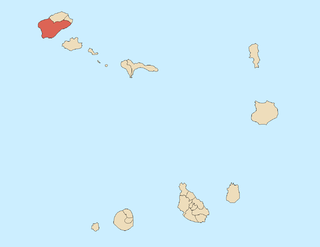
Santo André is a freguesia of Cape Verde. It covers the smaller, northwestern part of the municipality of Porto Novo, on the island of Santo Antão.

Ribeira da Garça river in Cape Verde

Ribeira da Garça is a river in the northern part of the island of Santo Antão in Cape Verde. Its source is on the north side of the eastern plateau of the island, northeast of Pico Moroços. It flows north through the settlements of Garça de Cima and Chã de Igreja, in the western part of the municipality of Ribeira Grande. It flows into the Atlantic Ocean near Chã de Igreja.

Ribeira do Paul river in Cape Verde

Ribeira do Paul is a seasonal stream that flows in the northeastern part of the island of Santo Antão in Cape Verde. The stream flows from southwest to northeast. The upper part of the valley belongs to Cova-Paul-Ribeira da Torre Natural Park.

Ribeira Grande (stream) river in Cape Verde

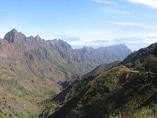
Ribeira Grande is a stream in the northeastern part of the island of Santo Antão in Cape Verde. The stream flows from west-southwest to east-northeast, through a steep and narrow gorge. The river begins near Lombo Santa, passes through Boca de Ambas Ribeiras, Boca de Coruja and Coculi, and flows into the Atlantic Ocean at the town of Ribeira Grande. Its most important tributaries are the Ribeira de Chã das Pedras, and the Ribeira da Torre, that joins the Ribeira Grande in the town Ribeira Grande.

Póvoa de Varzim beaches

The beaches in Póvoa de Varzim are an extensive and continuous group of golden sandy beaches forming small bays or coves along the shoreline in northern Portugal. These do not have any barrier and are in fact a single beach, over 12 km long, under the name Praia da Póvoa de Varzim. Division may be arbitrary and serve localization porpoises.

Ribeira da Torre river in Cape Verde

Ribeira da Torre is a torrential stream in the northeastern part of the island of Santo Antão in Cape Verde. Its source is in the mountains north of the Cova crater, near the locality Rabo Curto. It flows to the north through the settlements Xoxo, Fajã Domingas Benta and Lugar de Guene. In the city Ribeira Grande it flows into the river Ribeira Grande, just upstream of its outflow into the Atlantic Ocean. Its upper valley is part of the protected area Cova-Paul-Ribeira da Torre Natural Park. There is small-scale agriculture in the valley, producing sugar cane, coffee, yam, banana, papaya and mango.

José Lopes da SIlva was a Cape Verdean professor, journalist and poet.

Alto Miramar Neighbourhood in Mindelo, São Vicente Island, Cape Verde

Alto Miramar is a subdivision of the city of Mindelo in the island of São Vicente, Cape Verde. Its population was 524 at the 2010 census. It is situated directly northeast of the city centre. The main streets of the neighbourhood are Rua Unidade Africana and Rua da Paz.

Fonte Cónego Neighborhood in Mindelo, São Vicente Island, Cape Verde

Fonte Cónego is a subdivision of the city of Mindelo in the island of São Vicente, Cape Verde. Its population was 236 at the 2010 census. It is situated directly east of the city centre. Adjacent neighborhoods include Alto Miramar to the northwest, Alto Santo António to the north, Alto Solarine/Forca to the northeast and Ribeira Bote to the south.

Amarilson Monteiro, better known as Xolote, is a Cape Verdean professional footballer who plays as a forward for the Cape Verdean club Académica do Porto Novo.

References

  1. "Santo Antão: Agricultores de Alto Mira querem apoio do MDR para compensar estragos nas culturas". Inforpress CV (in Portuguese). Praia. 2015-09-09. Archived from the original on 2015-10-01. Retrieved 2015-09-21.