Ribeira da Garça

Last updated
Ribeira da Garça
RibeiraGarcaCanhao.JPG
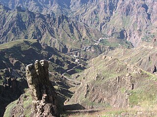
The Garça Valley at Chã da Igreja in 2008, since 2014, the road crosses through and behind the cliff is the Canto de Cagarra Dam
Country Cape Verde
Physical characteristics
Main source Gudo de Cavaleiro,
Santo Antão
River mouth Atlantic Ocean
17°09′58″N25°10′12″W / 17.166°N 25.170°W / 17.166; -25.170 Coordinates: 17°09′58″N25°10′12″W / 17.166°N 25.170°W / 17.166; -25.170
Length 8 km (5.0 mi)

Ribeira da Garça [1] is a river in the northern part of the island of Santo Antão in Cape Verde. Its source is on the north side of the main range of the island. It flows north through the settlements of Garça de Cima and Chã de Igreja and the west of the municipality of Ribeira Grande, and drains into the Atlantic Ocean in the north nearly 10 km west of Ribeira Grande. Hamlets located near or by the stream includes Horta da Garça, Cagarra, Manta Velha and Fundo. Parts of the river features some cliffs that are 30 to 40 meters high.

Santo Antão, Cape Verde Westernmost and largest of the Barlavento islands of Cape Verde

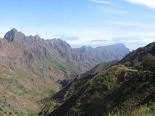
Santo Antão is the westernmost island of Cape Verde. At 779 km2 (301 sq mi), it is the largest of the Barlavento Islands group, and the second largest island of Cape Verde. The nearest island is São Vicente to the southeast, separated by the sea channel Canal de São Vicente. Its population was 40,547 in 2015, making it the third most populous island of Cape Verde after Santiago and São Vicente. Its largest city is Porto Novo on the south coast.

Cape Verde Country comprising ten islands off the Northwest coast of Africa

Cape Verde or Cabo Verde, officially the Republic of Cabo Verde, is an island country spanning an archipelago of 10 volcanic islands in the central Atlantic Ocean. It forms part of the Macaronesia ecoregion, along with the Azores, Canary Islands, Madeira, and the Savage Isles. In ancient times these islands were referred to as "the Islands of the Blessed" or the "Fortunate Isles". Located 570 kilometres (350 mi) west of the Cape Verde Peninsula off the coast of Northwest Africa, the islands cover a combined area of slightly over 4,000 square kilometres (1,500 sq mi).

Garça de Cima Settlement in Santo Antão, Cape Verde

Garça de Cima is a settlement in the northern part of the island of Santo Antão, Cape Verde. It is situated in the upper valley of the river Ribeira da Garça, 15 km northwest of the island capital Porto Novo. The southernmost part lies in Moroços Natural Park.

Contents

View of the head of the valley Vallee de Garca Cap-Vert.JPG
View of the head of the valley

The stream starts in Lombo de Gudo as Cabuco Dragum located north of Gudo dos Moroços (1,604 m) inside Moroços Natural Park, it is also north of Gudo de Cavaleiro (1,810 m).

Moroços Natural Park, in the middle of the island of Santo Antão, is one of ten "natural parks" in Cape Verde. The protected area is 8.18 km2 (3.16 sq mi). It covers 7.46 km2 (2.88 sq mi) of the municipality of Ribeira Grande, and 0.71 km2 (0.27 sq mi) of Porto Novo.

Gudo de Cavaleiro mountain in Cape Verde

Gudo de Cavaleiro is a mountain in the middle of the island Santo Antão in Cape Verde. Its elevation is 1,810 meters. Part of the eastern plateau of Santo Antão, it lies directly south of the Moroços natural park. Nearby places are the villages Alto Mira to the west and Lagoa to the east. The mountain lies on the border of the municipalities Ribeira Grande and Porto Novo.

Midway in the area where the reservoirs stands is a mountain to the east and further east is the source of Ribeira Grande.

Ribeira Grande (stream) river in Cape Verde

Ribeira Grande is a stream in the northeastern part of the island of Santo Antão in Cape Verde. The stream flows from west-southwest to east-northeast, through a steep and narrow gorge. The river begins near Lombo Santa, passes through Boca de Ambas Ribeiras, Boca de Coruja and Coculi, and flows into the Atlantic Ocean at the town of Ribeira Grande. Its most important tributaries are the Ribeira de Chã das Pedras, and the Ribeira da Torre, that joins the Ribeira Grande in the town Ribeira Grande.

Mouth of the Ribeira da Garca. The alluvial terrace, 40 meters above sea level, is clearly visible RibeiraGarcaFoz.JPG
Mouth of the Ribeira da Garça. The alluvial terrace, 40 meters above sea level, is clearly visible

Canto de Cagarra Dam

The Canto de Cagarra Dam (Barragem de Canto de Cagarra) has been constructed and was finished on November 16, 2014, [2] the only large dam on the island as well as the Barlavento Islands located roughly in the middle of the stream. The reservoir is predominantly dry and is one of the two in Cape Verde, the other is Salineiro on the Ribeira Grande de Santiago north of Cidade Velha on Santiago Island.

Salineiro Settlement in Santiago, Cape Verde

Salineiro is a village in the southern part of the island of Santiago, Cape Verde. It is part of the municipality of Ribeira Grande de Santiago. In 2010 its population was 1,113. It is located on the western edge of the Ribeira Grande gorge, 2.5 km north of Cidade Velha and 11 km west of the capital Praia.

Cidade Velha Settlement in Santiago, Cape Verde

Cidade Velha is a city in the southern part of the island of Santiago, Cape Verde. Founded in 1462, it is the oldest settlement in Cape Verde and its former capital. Once called Ribeira Grande, its name was changed to Cidade Velha in the late 18th century. It is the seat of the Ribeira Grande de Santiago municipality.

Santiago, Cape Verde largest island of Cape Verde

Santiago is the largest island of Cape Verde, its most important agricultural centre and home to half the nation’s population. Part of the Sotavento Islands, it lies between the islands of Maio and Fogo. It was the first of the islands to be settled: the town of Ribeira Grande was founded in 1462. Santiago is home to the nation's capital city of Praia.

Hurricane Fred filled up Canto de Cagarra dam on September 2015 and irrigated drought-stricken lands. [3]

Hurricane Fred (2015) 2015 hurricane

Hurricane Fred was the easternmost Atlantic hurricane to form in the tropics, and the first to move through Cape Verde since 1892. The second hurricane and sixth named storm of the 2015 Atlantic hurricane season, Fred originated from a well-defined tropical wave over West Africa in late August 2015. Once offshore, the wave moved northwestward within a favorable tropospheric environment and strengthened into a tropical storm on August 30. The following day, Fred grew to a Category 1 hurricane with peak winds of 85 mph (140 km/h) as it approached Cape Verde. After passing Boa Vista and moving away from Santo Antão, it entered a phase of steady weakening, dropping below hurricane status by September 1. Fred then turned to the west-northwest, enduring increasingly hostile wind shear, but maintained its status as a tropical cyclone despite repeated forecasts of imminent dissipation. It fluctuated between minimal tropical storm and tropical depression strength through September 4–5. Curving sharply to the north, Fred's circulation pattern had diminished considerably by September 6, and the storm dissipated later that day.

See also

Related Research Articles

Ribeira Grande, Cape Verde (municipality) Municipality in Santo Antão, Cape Verde

Ribeira Grande is a concelho (municipality) of Cape Verde. Situated in the northern part of the island of Santo Antão, it covers one fifth of the island area, and is home to nearly half of its population. Its seat is the city Ponta do Sol.

Ponta do Sol, Cape Verde Settlement in Santo Antão, Cape Verde

Ponta do Sol is the northernmost city on the island of Santo Antão and Cape Verde. It is situated on the coast, 4 km northwest of Ribeira Grande and 20 km north of the island capital Porto Novo. It is the seat of Ribeira Grande municipality.

Alto Mira Settlement in Santo Antão, Cape Verde

Alto Mira is a settlement in the northwestern part of the island of Santo Antão, Cape Verde. It is situated 4 km southeast of Ribeira da Cruz and 18 km northwest of the island capital Porto Novo. Its population was 1,003 at the 2010 census. The Moroços Natural Park lies east of the settlement. The settlement is divided into several localities, including Chã Bonita, Chã Daurinca, Chã de Dragoeiro, Dominguinhas, Faial and Lombo Gorado. The Ribeira Alto Mira flows through the settlement.

Coculi Settlement in Santo Antão, Cape Verde

Coculi is a town in the northern part of the island of Santo Antão, Cape Verde. It is situated on the river Ribeira Grande, 4 km southwest of the town Ribeira Grande and 17 km north of the island capital Porto Novo. About 400 meters to its west is the confluence of Ribeira de Chã das Pedras.

Cruzinha village in Cape Verde

The Cruzinha Nature Reserve is a protected area in the northern part of the island of Santo Antão in the Cape Verde archipelago. It covers part of the north coast of the island, between the rivers Ribeira da Garça and the Ribeira do Mocho. It contains the only coastal dunes of Santo Antão. It takes its name from the village Cruzinha da Garça, part of the town Chã de Igreja.

Santo André (Porto Novo) Civil parish in Santo Antão, Cape Verde

Santo André is a freguesia of Cape Verde. It covers the smaller, northwestern part of the municipality of Porto Novo, on the island of Santo Antão.

São Pedro Apóstolo Civil parish in Santo Antão, Cape Verde

São Pedro Apóstolo is a freguesia of Cape Verde. It covers the western part of the municipality of Ribeira Grande, on the island of Santo Antão.

Ribeira do Paul river in Cape Verde

Ribeira do Paul is a seasonal stream that flows in the northeastern part of the island of Santo Antão in Cape Verde. The stream flows from southwest to northeast. The upper part of the valley belongs to Cova-Paul-Ribeira da Torre Natural Park.

Chã de Igreja Settlement in Santo Antão, Cape Verde

Chã de Igreja is a town in the northern part of the island of Santo Antão, Cape Verde. It is situated near the north coast of the island, in the valley of the river Ribeira da Garça, 19 km northwest of the island capital Porto Novo. In 2010 its population was 672. The nature reserve Cruzinha, which includes the small seaside village Cruzinha da Garça, stretches northeast of Chã de Igreja along the coast.

Ribeira Grande, Cape Verde Settlement in Santo Antão, Cape Verde

Ribeira Grande is the largest town of the Ribeira Grande Municipality on the island of Santo Antão, Cape Verde. It has become a city in 2010. In 2010 its population was 2,564. It is situated in the northeastern part of the island, near the outflow of the river Ribeira Grande and its tributary Ribeira da Torre into the Atlantic Ocean. Neighborhoods include Tarrafal, Rua de Agua, Rua d'Horta and Penha de França.

Ribeira da Torre river in Cape Verde

Ribeira da Torre is a torrential stream in the northeastern part of the island of Santo Antão in Cape Verde. Its source is in the mountains north of the Cova crater, near the locality Rabo Curto. It flows to the north through the settlements Xoxo, Fajã Domingas Benta and Lugar de Guene. In the city Ribeira Grande it flows into the river Ribeira Grande, just upstream of its outflow into the Atlantic Ocean. Its upper valley is part of the protected area Cova-Paul-Ribeira da Torre Natural Park. There is small-scale agriculture in the valley, producing sugar cane, coffee, yam, banana, papaya and mango.

Xoxo, Cape Verde Settlement in Santo Antão, Cape Verde

Xoxo is a settlement in the northeastern part of the island of Santo Antão in Cape Verde. It is situated 5 kilometres (3.1 mi) south of Ribeira Grande and 13 kilometres (8.1 mi) north of the island capital Porto Novo. The settlement lies in Cova-Paul-Ribeira da Torre Natural Park. The Ribeira da Torre flows through the settlement. The only road to Xoxo goes from Ribeira Grande through the Ribeira da Torre valley.

Ribeira de Alto Mira

Ribeira de Alto Mira is a stream in the northwestern part of the island of Santo Antão in Cape Verde. Its source is west of the mountain Gudo de Cavaleiro. It flows towards the northwest, entirely within the parish of Santo André, Porto Novo municipality. It passes the settlements of Alto Mira and Chã de Branquinho before emptying into the Atlantic Ocean.

References

  1. http://dialnet.unirioja.es/servlet/fichero_articulo?codigo=2800296&orden=0
  2. "Santo Antão: Barragem de Canto de Cagarra foi inaugurada hoje" [Canto de Cagarra Dam to be Completed Today]. Inforpress (in Portuguese). 15 November 2014. Archived from the original on 29 November 2014. Retrieved 16 November 2014.
  3. "Chuvas fazem transbordar barragens de Faveta e de Canto de Cagarra" [Rainfall Filled Up the Dams of Faveta and Canto de Cagarra]. A Semana (in Portuguese). Praia. 2015-09-02. Retrieved 2015-09-20.

Further reading