
Chiricahua is a band of Apache Native Americans.

Mission San Xavier del Bac is a historic Spanish Catholic mission located about 10 miles (16 km) south of downtown Tucson, Arizona, on the Tohono O'odham Nation San Xavier Indian Reservation. The mission was founded in 1692 by Padre Eusebio Kino in the center of a centuries-old settlement of the Sobaipuri O'odham, a branch of the Akimel or River O'odham located along the banks of the Santa Cruz River. The mission was named for Francis Xavier, a Christian missionary and co-founder of the Society of Jesus in Europe. The original church was built to the north of the present Franciscan church. This northern church or churches served the mission until it was razed during an Apache raid in 1770.

Peridot is an unincorporated community and census-designated place (CDP) in Gila and Graham counties in the U.S. state of Arizona. The population was 1,350 at the 2010 census.
The Apache are several Southern Athabaskan language–speaking peoples of the Southwest, the Southern Plains and Northern Mexico. They are linguistically related to the Navajo. They migrated from the Athabascan homelands in the north into the Southwest between 1000 and 1500 CE.

The Western Apache are a subgroup of the Apache Native American people, who live primarily in east central Arizona, in the United States and north of Mexico in the states of Sonora and Chihuahua. Most live within reservations. The Fort Apache Indian Reservation, San Carlos Apache Indian Reservation, Yavapai-Apache Nation, Tonto Apache, and the Fort McDowell Yavapai Nation are home to the majority of Western Apache and are the bases of their federally recognized tribes. In addition, there are numerous bands. The Western Apache bands call themselves Ndee (Indé). Because of dialectical differences, the Pinaleño/Pinal and Arivaipa/Aravaipa bands of the San Carlos Apache pronounce the word as Innee or Nnēē:.

The Yavapai–Apache Nation is a federally recognized Native American tribe in the Verde Valley of Arizona. Tribal members share two culturally distinct backgrounds and speak two indigenous languages, the Yavapai language and the Western Apache language.

The Apache Wars were a series of armed conflicts between the United States Army and various Apache tribal confederations fought in the southwest between 1849 and 1886, though minor hostilities continued until as late as 1924. After the Mexican–American War in 1846, the United States annexed conflicted territory from Mexico which was the home of both settlers and Apache tribes. Conflicts continued as American settlers came into traditional Apache lands to raise livestock and crops and to mine minerals.

The Tonto Apache is one of the groups of Western Apache people and a federally recognized tribe, the Tonto Apache Tribe of Arizona. The term is also used for their dialect, one of the three dialects of the Western Apache language.

The San Carlos Apache Indian Reservation, in southeastern Arizona, United States, was established in 1872 as a reservation for the Chiricahua Apache tribe as well as surrounding Yavapai and Apache bands removed from their original homelands under a strategy devised by General George Crook of setting the various Apache tribes against one another. Once nicknamed "Hell's Forty Acres" during the late 19th century due to poor health and environmental conditions, today's San Carlos Apaches successfully operate a Chamber of Commerce, the Apache Gold and Apache Sky Casinos, a Language Preservation program, a Culture Center, and a Tribal College.

The Camp Grant massacre, on April 30, 1871, was an attack on Pinal and Aravaipa Apaches who surrendered to the United States Army at Camp Grant, Arizona, along the San Pedro River. The massacre led to a series of battles and campaigns fought between the Americans, the Apache, and their Yavapai allies, which continued into 1875, the most notable being General George Crook's Tonto Basin Campaign of 1872 and 1873.
The Western Apache language is a Southern Athabaskan language spoken among the 14,000 Western Apaches in Mexico in the states of Sonora and Chihuahua and in east-central Arizona. There are approximately 6,000 speakers living on the San Carlos Reservation and 7,000 living on the Fort Apache Reservation. In Mexico, they mainly live in Hermosillo, Sonora, and other native communities in Chihuahua. Goodwin (1938) claims that Western Apache can be divided into five dialect groupings:

The Yavapai are a Native American tribe in Arizona. Historically, the Yavapai – literally “people of the sun” – were divided into four geographical bands who identified as separate, independent peoples: the Ɖulv G’paaya, or Western Yavapai; the Yaavpe', or Northwestern Yavapai; the Gwev G’paaya, or Southeastern Yavapai; and the Wiipukpaa, or Northeastern Yavapai – Verde Valley Yavapai.

U.S. Route 70 (US 70), also known as the Old West Highway, is an east–west U.S. Highway in the U.S. state of Arizona. The current route starts at US 60 in Globe and runs through the San Carlos Indian Reservation, Safford and Duncan into New Mexico near Virden. In Arizona, US 70 passes through mostly isolated hilly and mountainous terrain largely paralleling the course of the Gila River and the Arizona Eastern Railway.

Fort Grant is a state prison and a former United States Army fortification in the U.S. state of Arizona. Fort Grant is located on the southwestern slope of Mount Graham in what is now Graham County. The post is named for Ulysses S. Grant, the 18th President of the United States.
The Fort Sill Apache Tribe of Oklahoma is the federally recognized Native American tribe of Chiricahua Warm Springs Apache in Oklahoma.
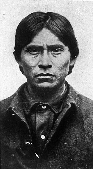
Haskay-bay-nay-ntayl, better known as the Apache Kid, was born in Aravaipa Canyon, 25 miles south of San Carlos Agency, into one of the three local groups of the Aravaipa/Arivaipa Apache Band of San Carlos Apache, one subgroup of the Western Apache people. As a member of what the U.S. government called the "SI band", Kid developed important skills and became a famous and respected scout and later a notorious renegade active in the borderlands of the U.S. states of Arizona and New Mexico in the late 19th and possibly the early 20th centuries.
The Yavapai Wars, or the Tonto Wars, were a series of armed conflicts between the Yavapai and Tonto tribes against the United States in the Arizona Territory. The period began no later than 1861, with the arrival of American settlers on Yavapai and Tonto land. At the time, the Yavapai were considered a band of the Western Apache people due to their close relationship with tribes such as the Tonto and Pinal. The war culminated with the Yavapai's removal from the Camp Verde Reservation to San Carlos on February 27, 1875, an event now known as Exodus Day.

Clay Beauford was an American army officer, scout and frontiersman. An ex-Confederate soldier in his youth, he later enlisted in the U.S. Army and served with the 5th U.S. Cavalry during the Indian Wars against the Plains Indians from 1869 to 1873. He acted as a guide for Lieutenant Colonel George Crook in his "winter campaign" against the Apaches and received the Medal of Honor for his conduct.
Camp Grant was the name used from 1866 to 1872 for the United States military post at the confluence of the San Pedro River and Aravaipa Creek in the Arizona Territory. It is near the site of the Camp Grant massacre.


