
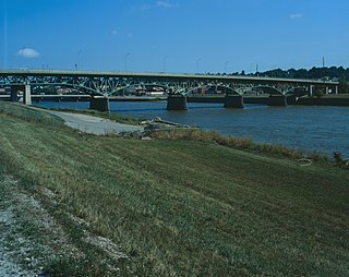
The Miami Bridge, also known as the McDaniel Memorial Bridge, is a new concrete girder bridge that was built to replace a cantilever through truss bridge over the Missouri River at Miami, Missouri between Saline County, Missouri and Carroll County, Missouri. The Miami Bridge carries Route 41. The Miami Bridge was built in 1939, and its deck was replaced in 1983 as part of a rehabilitation project. The old bridge's main cantilever span was 474.7 feet, while the two anchor spans were each 415 feet in length, resulting in a total cantilever truss length of 1304.7 feet. There were 11 approach spans, including four Warren deck truss spans, three on the northern approach and one on the southern approach. All remaining approach spans were steel stringer (multi-beam/girder) spans. Total bridge length including approach spans is 2,071.9 feet. The bridge's deck width is 23.0 feet and it has vertical clearance of 16.5 feet.

The Riverside Avenue Bridge is the only cast-iron bridge in Connecticut and one of a small number still in use in the United States. It carries Riverside Avenue over the New Haven Line railroad tracks in the Riverside section of Greenwich, Connecticut. The bridge was part of an earlier span built in 1871 over the Housatonic River by the New York and New Haven Railroad, and when that bridge was replaced, part of it was erected in Riverside in 1895. It was placed on the National Register of Historic Places in 1977.

19th Street Bridge is a two-span through Pratt truss road bridge in Denver, Colorado, over the South Platte River, now used for pedestrians. It was built in 1888 to replace a wooden structure and carried automobile traffic until 1986. The bridge is listed on the National Register of Historic Places.

Chevelon Creek Bridge is a historic road bridge located about 12 miles (19 km) southeast of Winslow, in Navajo County, eastern Arizona, United States. It is a steel Warren Pony truss bridge over Chevelon Creek, built on the first permanent road connecting Holbrook, the seat of Navajo County, and Winslow. When built, the road was regionally important in northern Arizona as well as being a segment of an early national highway at the time automobile traffic was growing and national roads were first being formed. The bridge was listed on the National Register of Historic Places in 1983 for being a rare design in Arizona, part of an early transnational roadway, one of the first bridges built by Arizona after statehood in 1912, and being in nearly original condition.
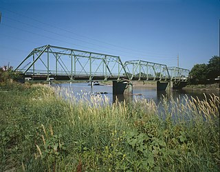
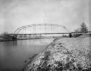
The Southwest Fifth St. Bridge is an historic structure located in downtown Des Moines, Iowa, United States. Built in 1898 after a controversy surrounding the bidding process, it is one of the last Pratt through truss bridges left in an urban setting in Iowa. The bridge was listed on the National Register of Historic Places in 1998 as a part of the Highway Bridges of Iowa MPS.
The Jefferson Street Viaduct is an historic structure located in Ottumwa, Iowa, United States. The riveted Warren deck truss bridge was completed in 1936. It was listed on the National Register of Historic Places in 1998 as a part of the Highway Bridges of Iowa MPS.

The Cameron Suspension Bridge crosses the Little Colorado River at Cameron, Arizona, United States.
The EDZ Irigary Bridge is a historic Pennsylvania truss bridge in southeastern Johnson County, Wyoming. The bridge was built in 1913 at Sussex, Wyoming, and moved in 1963 to Irigary Road. The bridge was listed on the National Register of Historic Places in 1985 as part of a Multiple Property Submission devoted to historic bridges in Wyoming.

The AJX Bridge is a historic Pratt truss bridge in southwestern Johnson County, Wyoming. The bridge was built in 1931 across the South Fork of the Powder River near Kaycee, Wyoming. AJX Bridge was built to provide a river crossing for U.S. Route 87. It was placed on the National Register of Historic Places in 1985 as part of a Multiple Property Submission devoted to historic bridges in Wyoming.
Four historic bridges on the Big Thompson River in Larimer County, Colorado survived its flood of 1976, but since have lost most of their historic integrity. They were built in 1933 and 1937. All four were listed on the National Register of Historic Places in 2002, and two were delisted in 2010.

The EAU Arvada Bridge was a Parker through truss bridge located near Arvada, Wyoming, which carried Sheridan County Road CN3-38 across the Powder River. The bridge was built in 1917 by the Monarch Engineering Company of Denver. The single-span 8-panel bridge was 162 feet (49 m) long and was connected by steel pins. When nominated to the National Register of Historic Places in 1982, it was one of only two Parker through truss bridges remaining in Wyoming.

The Antelope Hill Highway Bridge is a historic bridge over the Gila River in Tacna, Arizona, U.S. It was built between 1914 ad 1915 as a ten-span concrete girder bridge. The bridge served as an integral piece of the Ocean to Ocean Highway between Yuma and Phoenix from 1915 to 1922, when it was bypassed by an alternate route through Gila Bend, paralleling the Gillespie Dam. The bridge and original highway were bypassed mainly due to damage caused by flooding along the river floodplain it was constructed on. After being repurposed for traffic traveling north from Yuma, the bridge was finally abandoned in 1929 following completion of the McPhaul Suspension Bridge. The ruins of the old bridge are currently listed on the National Register of Historic Places.

The Ocean-to-Ocean Bridge is a through truss bridge spanning the Colorado River in Yuma, Arizona. Built in 1915, it was the first highway crossing of the lower Colorado and is the earliest example of a through truss bridge in Arizona. It is also the only example of a Pennsylvania truss within Arizona. Originally the bridge carried the transcontinental Ocean-to-Ocean Highway and later carried its successor, US 80 until a new bridge was built to the west in 1956. Between 1988 and 2001, the bridge was closed to vehicular traffic and only traversable by pedestrians and bicyclists. After a major restoration, the bridge was rehabilitated and reopened to vehicular traffic in 2002, with a re-dedication by the Quechan nation and Yuma Crossing National Heritage Area. The bridge became part of Historic US 80 in 2018.

The Hassayampa Bridge is a bridge spanning the Hassayampa River in Hassayampa, Arizona, located in Maricopa County. The bridge was completed in 1929 and was listed on the National Register of Historic Places in 1988. The bridge was scheduled for demolition in 1983.

The Allentown Bridge is a bridge spanning the Puerco River near Houck, Arizona, located in Apache County. The existing structure was completed in 1923 and is listed on the National Register of Historic Places.

The Gillespie Dam Bridge is a through truss bridge spanning the Gila River in Maricopa County, in the U.S. state of Arizona. The bridge was constructed to bypass a concrete apron through the river in front of the Gillespie Dam, which was often closed due to flooding. Construction of the bridge started in 1925 and completed in 1927. From its opening until 1956, the bridge was part of U.S. Route 80 (US 80), a transcontinental highway between San Diego, California and Tybee Island, Georgia. The bridge was restored in 2012 by Maricopa County for the Arizona Centennial and now includes an educational interpretive center for visitors. The bridge became part of Historic US 80 in 2018.
Querino Canyon Bridge is located approximately four miles (6.4 km) southwest of Houck, Arizona, on Old Route 66, over Querino Canyon.
Sanders Bridge is a steel truss bridge straddling the Puerco River, near Sanders, Arizona. It was constructed in 1923 and gained National Historic status in 1988.

The Rifle Bridge, over the Colorado River in Rifle, Colorado, was built in 1909. It was listed on the National Register of Historic Places in 1985.

The Dead Indian Canyon Bridge, near Desert View in Coconino County, Arizona, is a Warren truss bridge built in 1933 as part of developing public highway approach from the east to the south rim of the Grand Canyon. It was listed on the National Register of Historic Places in 1988.
