Richetli Pass

Last updated
Richetli Pass
Switzerland relief location map.jpg
Red pog.svg
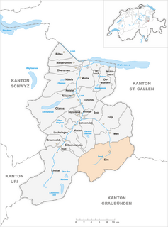
Richetli Pass
Location in Switzerland
Elevation 2,261 m (7,418 ft)
Traversed by Trail
Location Glarus, Switzerland
Range Glarus Alps
Coordinates 46°53′52.5″N09°04′02.5″E / 46.897917°N 9.067361°E / 46.897917; 9.067361 Coordinates: 46°53′52.5″N09°04′02.5″E / 46.897917°N 9.067361°E / 46.897917; 9.067361

The Richetli Pass (German : Richetlipass) is a high mountain pass in the Glarus Alps in the Swiss canton of Glarus. The pass crosses between the heads of the valleys of the Linth and the Sernf rivers, using the col between the Hausstock and Kärpf mountains, at an elevation of 2,261 m (7,418 ft). [1]

German language West Germanic language

German is a West Germanic language that is mainly spoken in Central Europe. It is the most widely spoken and official or co-official language in Germany, Austria, Switzerland, South Tyrol (Italy), the German-speaking Community of Belgium, and Liechtenstein. It is also one of the three official languages of Luxembourg and a co-official language in the Opole Voivodeship in Poland. The languages which are most similar to German are the other members of the West Germanic language branch: Afrikaans, Dutch, English, the Frisian languages, Low German/Low Saxon, Luxembourgish, and Yiddish. There are also strong similarities in vocabulary with Danish, Norwegian and Swedish, although those belong to the North Germanic group. German is the second most widely spoken Germanic language, after English.

Mountain pass Route through a mountain range or over a ridge

A mountain pass is a navigable route through a mountain range or over a ridge. Since many of the world's mountain ranges have presented formidable barriers to travel, passes have played a key role in trade, war, and both human and animal migration throughout Earth's history. At lower elevations it may be called a hill pass. The highest vehicle-accessible pass in the world appears to be Mana Pass, located in the Himalayas on the border between India and Tibet, China.

Glarus Alps mountain range

The Glarus Alps are a mountain range in central Switzerland. They are bordered by the Uri Alps and the Schwyz Alps to the west, the Lepontine Alps to the south, the Appenzell Alps to the northeast. The eastern part of the Glarus Alps contains a major thrust fault which was declared a geologic UNESCO world heritage site.

Contents

The pass is traversed by a trail, which connects the village of Elm, at an elevation of 977 m (3,205 ft) with the village of Linthal, at an elevation of 650 m (2,130 ft). The trail forms part of the Alpine Pass Route, a long-distance hiking trail across Switzerland between Sargans and Montreux. [1] [2]

Linthal, Glarus Village in Glarus, Switzerland

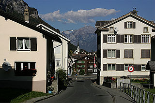
Linthal is a village, and former municipality, in the municipality of Glarus Süd and canton of Glarus in Switzerland. The village lies near the head of the valley of the Linth river, and at the foot of the Klausen Pass into the canton of Uri. It is the terminus of the railway line that traverses the length of Glarus.

The Alpine Pass Route is a long-distance hiking trail through the Alps in Switzerland, part of the Via Alpina route. It starts in Sargans in eastern Switzerland, and crosses the heart of country westwards to finish in Montreux on the shore of Lake Geneva. The total route covers over 325 kilometres (202 mi) and crosses 16 mountain passes, and takes 15 or more walking days to complete.

Sargans Place in St. Gallen, Switzerland

Sargans is a municipality in the Wahlkreis (constituency) of Sarganserland in the canton of St. Gallen in Switzerland.

See also

Related Research Articles

Tödi highest mountain in the Glarus Alps

The Tödi, is a mountain massif and with the mountain peak Piz Russein the highest mountain in the Glarus Alps and the highest summit in the canton of Glarus, Switzerland. It is located on the border between the cantons of Graubünden, to the south, and Glarus, to the north, close to the point where those two cantons meet the canton of Uri, to the west. Although not the culminating point of Graubünden, it is its highest peak outside the Bernina range.

Kleine Scheidegg mountain pass

The Kleine Scheidegg is a mountain pass at an elevation of 2,061 m (6,762 ft), situated below and between the Eiger and Lauberhorn peaks in the Bernese Oberland region of Switzerland. The name means "minor watershed", even though it is actually higher than the neighbouring Grosse Scheidegg. Possibly this is because Kleine Scheidegg is a watershed between the two arms of the Lütschine river, while Grosse Scheidegg divides the Lütschine from the Rychenbach stream.

Klausen Pass mountain pass in Switzerland, between Uri and Glarus cantons

Klausen Pass is a high mountain pass in the Swiss Alps connecting Altdorf in the canton of Uri with Linthal in the canton of Glarus. Somewhat unusually, the boundary between the two cantons does not lie at the summit of the pass, but some 8 kilometres (5.0 mi) down the slope towards Linthal, with the summit being in Uri.

Grosse Scheidegg mountain pass

The Grosse Scheidegg is a mountain pass in the Bernese Alps of Switzerland, The pass crosses the col between the Schwarzhorn and the Wetterhorn mountains at an elevation of 1,962 m (6,437 ft).

Elm, Switzerland Village in Glarus, Switzerland

Elm is a village, and former municipality, in the municipality of Glarus Süd and canton of Glarus in Switzerland. Elm lies in the valley of the Sernf river, and consists of the village of Elm itself, and the hamlets of Sulzbach, Schwändi, Müsli, Untertal, Vogelsang, Töniberg, Obmoos, Steinibach and Wald.

Matt, Switzerland Village in Glarus, Switzerland

Matt is a village, and former municipality, in the municipality of Glarus Süd and canton of Glarus in Switzerland. Matt lies in the valley of the Sernf river, and consists of the village of Matt itself, and the mountain hamlet of Weissenberge.

Diesbach, Glarus Village in Glarus, Switzerland

Diesbach is a village, and former municipality, in the municipality of Glarus Süd and canton of Glarus in Switzerland.

Clariden mountain in the Glarus Alps

The Clariden is a mountain in the Glarus Alps, located at an elevation of 3,267 m (10,719 ft) between the Swiss cantons of Uri and Glarus. While on the north the Clariden overlooks the 1,948 m (6,391 ft) high Klausen Pass, the south side is covered by large glaciers. The Hüfifirn on the west is drained by the Chärstelenbach, a tributary of the Reuss that eventually flows into Lake Lucerne. The Claridenfirn on the east is drained by the Linth that eventually flows into Lake Zürich.

Hausstock mountain in the Glarus Alps

The Hausstock is a mountain in the Glarus Alps, at an elevation of 3,158 m (10,361 ft) on the border between the cantons of Glarus and Graubünden. It overlooks the valleys of Linth and Sernf rivers in Glarus, and the valley of the Vorderrhein river in Graubünden. The Hausstock was the site of the 1799 withdrawal of the Russian army under General Alexander Suvorov. A well-known destination already in the nineteenth century with British and American climbers, the mountain remains popular with mountain climbers and skiers.

Piz Sardona mountain

Piz Sardona is a mountain in the Glarus Alps, located on the border between the cantons Glarus and St. Gallen. The 3,056 metres high mountain overlooks the valleys of Elm (Glarus) and Calfeisen. Less than one kilometre south of the summit lies the tripoint between the cantons of Glarus, St. Gallen and Graubünden. The summit itself is the northernmost point above 3,000 metres in Switzerland.

Foostock

The Foostock, also known as the Ruchen, is a mountain of the Glarus Alps, located on the border between the Swiss cantons of Glarus and St. Gallen. It lies north of Piz Sardona, on the range that separates the Sernftal from the Weisstannental.

Weisstannen village in Switzerland

Weisstannen is a village located in the canton of St. Gallen, Switzerland. It lies in the municipality of Mels, south-west of Sargans.

Hahnenmoos Pass mountain pass

The Hahnenmoos Pass is a mountain pass of the Bernese Alps. The pass crosses the col between the peaks of Regenboldshorn and Albristhorn, at an elevation of 1,950 m (6,400 ft). The Hahnenmoos Pass is the lowest pass between the Engstligental, to the east, and the upper Simmental, to the west.

Surenen Pass mountain pass in Central Switzerland

The Surenen Pass is a high mountain pass across the Urner Alps in the canton of Uri in Central Switzerland. The pass crosses the col between the Blackenstock and the Eggenmanndli peaks, at an elevation of 2,292 m (7,520 ft).

Joch Pass mountain pass in Switzerland, connecting Innertkirchen in the canton of Bern with Engelberg in the canton of Obwalden

The Joch Pass is a mountain pass of the Uri Alps, located between the Bernese Oberland and Central Switzerland, at the foot of the Titlis. The pass crosses the col between the peaks of Graustock and Jochstock, at an elevation of 2,207 m (7,241 ft) and at the border between the cantons of Bern and Nidwalden.

Foo Pass

The Foo Pass is a mountain pass of the Glarus Alps, located on the border between the Swiss cantons of St. Gallen and Glarus, at an elevation of 2,223 m (7,293 ft). It crosses the col between the peaks of Foostock and Piz Sardona.

Sefinenfurgge Pass mountain pass in the Swiss canton of Bern

The Sefinafurgga is a mountain pass of the Bernese Alps. The pass crosses the col between the peaks of Hundshore and Bütlasse, at an elevation of 2,612 m (8,570 ft).

Hohtürli mountain pass

The Hohtürli is a high Alpine hiking pass of the Bernese Alps. The pass crosses the col between the peaks of Wildi Frau and Dündenhorn, at an elevation of 2,778 m (9,114 ft).

Bunderchrinde Pass mountain pass

The Bunderchrinde Pass is a mountain pass of the Bernese Alps. The pass crosses the col between the peaks of Gross Lohner and Chlyne Lohner, at an elevation of 2,385 m (7,825 ft).

Riseten Pass

The Riseten Pass is a mountain pass of the Glarus Alps, located on the border between the Swiss cantons of St. Gallen and Glarus, at an elevation of 2,189 m (7,182 ft). It crosses the col between the peaks of the Wissgandstöckli and Foostock.

References

  1. 1 2 map.geo.admin.ch (Map). Swiss Confederation. Retrieved 2015-05-15.
  2. Reynolds, Kev (2011). "Trek 10 - Alpine Pass Route". Trekking in the Alps. Cicerone. pp. 124–135. ISBN   978 1 85284 600 8.