Richterich

Last updated
Richterich
Richterich Wappen.jpg
Location of Richterich
Richterich
Germany adm location map.svg
Red pog.svg
Richterich
North Rhine-Westphalia location map 01.svg
Red pog.svg
Richterich
Coordinates: 50°48′31″N6°3′45″E / 50.80861°N 6.06250°E / 50.80861; 6.06250 Coordinates: 50°48′31″N6°3′45″E / 50.80861°N 6.06250°E / 50.80861; 6.06250
Country Germany
State North Rhine-Westphalia
District Urban district
City Aachen
Area
  Total13.18 km2 (5.09 sq mi)
Elevation
186 m (610 ft)
Population
 (2020-12-31) [1]
  Total8,590
  Density650/km2 (1,700/sq mi)
Time zone UTC+01:00 (CET)
  Summer (DST) UTC+02:00 (CEST)
Dialling codes 0241

Richterich is a borough and northwestern suburb of Aachen, Germany. The towns of Horbach and Huf belong to the borough, which borders the other Aachen borough of Laurensberg, as well as the Kohlscheid borough of Herzogenrath. It is assumed that the histories of Richerich and Horbach go back a long time, since the name is suggestive of a Celtic settlement. In Roman times, the attested name of the area was recteriacum.

Contents

Buildings and history

St. Martin Church in Richterich St. martinus, Aachen-Richterich (2).JPG
St. Martin Church in Richterich

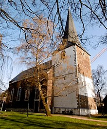
The most historically important buildings in the borough are the St. Martin Church (inaugurated 1791), the Schönau Castle (Schloss Schönau), and the water fortress Heyden House (Haus Heyden), in Horbach. St. Martin Church contains the Maaß Organ, which was built in 1836 and is the oldest organ in Aachen. Schönau Castle is today home to a restaurant and is available to residents as a cultural center and host to various events. Heyden House is now used for residential purposes. Besides a few houses from the 18th Century in the old village, there are several well-preserved old estates, such as the Gut Bau (built in 1750) and the Zehnthof, which is where farmers tithed what they owed during the Middle Ages. From 1911 until 1927 the Carl Friedrich mine was the most southerly mine of Aachen’s Wurmrevier coal region. The workforce consisted of about 500 people, but the mine was shut down after only 16 years, due to unfavorable tectonic conditions and poor coal quality.

Incorporation

On 1 January 1972, Richterich was incorporated into Aachen. A section of the community (which included Bank and Wilsberg and contained 1119 residents) was split off and merged with Herzogenrath. [2]

Transportation

Richterich formerly had its own train station on the Aachen–Mönchengladbach line, with a branch line to Vetschau. Passenger traffic at this station was discontinued in 1966. In 1992, the track to Simpelveld shut down entirely, and several hundred meters of track were removed in Vetschau.

Schools

There are two elementary schools in the district of Richterich: the GGS Richterich and the KGS Horbach. Also in Richterich are four preschools: the city-run preschools of Park Street (Parkstraße), Richterich Street (Richtericher Straße), and Green Valley Street (Grünenthaler Straße), as well as the Catholic preschool at St. Martin, which has had a cooperative agreement with RWTH Aachen University since 2005.

Sports and leisure

In Richterich, there are several sports clubs, including Rhenania Richterich, the Sports Club Horbach 1919, the Gymnastics Club Richterich 1885, the Fishing Club Richterich and the Fishing Club Horbach. There are also two Carnival Clubs (the 1st Carnival Club Koe Jonge Richterich 1956 and the Carnival Club Friends of Horbach 1998), a shooting club (the St. Hubert Shooting Brotherhood Richterich 1816), and the Instrumental Club Richterich 1887. A voluntary Fire Company—the Löschzug Richterich—has also existed since 1901.

Notable people

Related Research Articles

Aachen City in North Rhine-Westphalia, Germany

Aachen is, with around 249,000 inhabitants, the 13th-largest city in North Rhine-Westphalia, and the 28th-largest city of Germany.

Herne, North Rhine-Westphalia City in North Rhine-Westphalia, Germany

Herne is a city in North Rhine-Westphalia, Germany. It is located in the Ruhr area, directly between the cities of Bochum and Gelsenkirchen.

Wedding (Berlin) Quarter of Berlin in Germany

Wedding is a locality in the borough of Mitte, Berlin, Germany and was a separate borough in the north-western inner city until it was fused with Tiergarten and Mitte in Berlin's 2001 administrative reform. At the same time the eastern half of the former borough of Wedding—on the other side of Reinickendorfer Straße—was separated as the new locality of Gesundbrunnen.

Wenden (Sauerland) Town in North Rhine-Westphalia, Germany

Wenden is a community in North Rhine-Westphalia, Germany. It belongs to the Olpe district in the Sauerland. It lies 10 kilometres south of Olpe and 20 km (12 mi) northwest of Siegen.

Eschweiler Town in North Rhine-Westphalia, Germany

Eschweiler is a municipality in the district of Aachen in North Rhine-Westphalia in Germany on the river Inde, near the German-Belgian-Dutch border, and about 15 kilometres (9 mi) east of Aachen and 50 kilometres (31 mi) west of Cologne.

Herzogenrath Town in North Rhine-Westphalia, Germany

Herzogenrath is a municipality in the district of Aachen in the German state of North Rhine-Westphalia. It borders the Dutch town of Kerkrade, the national border in one section running along the middle of a main road and even directly through the centre of the cross-border Eurode office complex.

Würselen Town in North Rhine-Westphalia, Germany

Würselen is a town in the borough of Aachen, in North Rhine-Westphalia, Germany.

Stolberg (Rhineland) Town in North Rhine-Westphalia, Germany

Stolberg is a town in North Rhine-Westphalia, Germany. It has a long history as an industrial town and belongs to the district Aachen and the lower district court of Eschweiler.

Erkelenz Town in North Rhine-Westphalia, Germany

Erkelenz is a town in the Rhineland in western Germany that lies 15 kilometres southwest of Mönchengladbach on the northern edge of the Cologne Lowland, halfway between the Lower Rhine region and the Lower Meuse. It is a medium-sized town and the largest in the district of Heinsberg in North Rhine-Westphalia.

Alsdorf Town in North Rhine-Westphalia, Germany

Alsdorf is a municipality in the district of Aachen, in North Rhine-Westphalia, Germany. Until the 21st century Alsdorf was a mining area, but now many service companies have established themselves in Alsdorf. Alsdorf has an indoor arena, a cinema, a mining museum and a zoo. One of Alsdorf's famous sights is the old Castle.

Gemünden am Main Town in Bavaria, Germany

Gemünden am Main is a town in the Main-Spessart district in the Regierungsbezirk of Lower Franconia (Unterfranken) in Bavaria, Germany and lies roughly 40 km down the Main from Würzburg. Gemünden has around 10,000 inhabitants.

Norheim Municipality in Rhineland-Palatinate, Germany

Norheim is an Ortsgemeinde – a municipality belonging to a Verbandsgemeinde, a kind of collective municipality – in the Bad Kreuznach district in Rhineland-Palatinate, Germany. It belongs to the Verbandsgemeinde of Rüdesheim, whose seat is in the like-named town. Norheim is a state-recognized tourism community (Fremdenverkehrsort). and a winegrowing village.

Feilbingert Municipality in Rhineland-Palatinate, Germany

Feilbingert is an Ortsgemeinde – a municipality belonging to a Verbandsgemeinde, a kind of collective municipality – in the Bad Kreuznach district in Rhineland-Palatinate, Germany. It belongs to the Verbandsgemeinde of Bad Kreuznach, whose seat is in the like-named town. The municipality's name is a fusion of the names Feil and Bingert, borne by two formerly separate villages that likewise fused together.

Schönau im Mühlkreis is a municipality in the district of Freistadt in Upper Austria, Austria. As of January 2013, the village has 1899 inhabitants.

Garzweiler surface mine Surface lignite mine in Germany

The Tagebau Garzweiler is a surface mine in the German state of North Rhine-Westphalia. It is operated by RWE and used for mining lignite. The mine currently has a size of 48 km² and got its name from the village of Garzweiler which previously existed at this location. The community was moved to a section of Jüchen with the same name.

Verlautenheide Part of Aachen in North Rhine-Westphalia, Germany

Verlautenheide is a rural section of northeast Aachen, with a population of around 3500. The community lies within the administrative district of Haaren. Its highest point is the Haarberg.

Laurensberg is a quarter (Stadtteil) and borough (Stadtbezirk) of Aachen, Germany.

Brand is a borough of Aachen, Germany, with about 18,000 residents. The borough lies in the southern part of Aachen and borders Kornelimünster/Walheim, Forst, Oberforstbach und Eilendorf, as well as the town of Stolberg.

Eilendorf is a borough of Aachen, Germany, that has around 15000 inhabitants. The communities of Eilendorf and Nirm share a border with the other Aachen boroughs of Brand, Aachen-Mitte, and Haaren, as well as Atsch in Stolberg.

Kornelimünster/Walheim is the southernmost Stadtbezirk (borough) of Aachen, Germany, and borders the Eifel area of North Rhine-Westphalia, as well as Belgium. It became part of Aachen in 1972, after all of the communities surrounding the city were reorganized administratively. The countryside is called Münsterländchen.

References

  1. "Einwohnerstatistik (xlsx) 31.12.2020". Open Data Portal Aachen. Retrieved 24 September 2021.
  2. Bünermann, Martin; Köstering, Heinz (1975). Communities and Districts After the Area Community Reform in North Rhine-Westphalia (Die Gemeinden und Kreise nach der kommunalen Gebietsreform in Nordrhein-Westfalen). Köln: German Publishing Community (Deutscher Gemeindeverlag). ISBN   3-555-30092-X.