
The Rideau River is a river in Eastern Ontario, Canada. The river flows north from Upper Rideau Lake and empties into the Ottawa River at the Rideau Falls in Ottawa, Ontario. Its length is 146 kilometres (91 mi).

The Rideau Canal is a 202-kilometre long canal that links the Ottawa River at Ottawa with the Cataraqui River and Lake Ontario at Kingston, Ontario, Canada. Its 46 locks raise boats from the Ottawa River 83 metres upstream along the Rideau River to the Rideau Lakes, and from there drop 50 metres downstream along the Cataraqui River to Kingston.

The Rideau Centre is a three-level shopping centre on Rideau Street in Ottawa, Ontario, Canada. It borders on Rideau Street, the ByWard Market, the Rideau Canal, the Mackenzie King Bridge, and Nicholas Street in Downtown Ottawa. Over 20 million people visit the mall annually. It is the largest shopping mall in the National Capital Region and the sixth largest mall, by area, in Canada. The Rideau Centre complex has approximately 180 retailers and is connected to a rooftop park, a Westin Hotel, the Shaw Centre, the Freiman Mall and the Major-General George R Pearkes Building.

Vanier, formerly Eastview, is a neighbourhood in the Rideau-Vanier Ward of the east end of Ottawa, Ontario, Canada. Historically francophone and working class, the neighbourhood was a separate city until being amalgamated into Ottawa in 2001. It no longer has a majority francophone population. By 2012 its francophone population had shrunk to less than 40% from 63% in the early 1980s. The neighbourhood is located on the east bank of the Rideau River, across from the neighbourhoods of Lowertown and Sandy Hill, and just south of Rockcliffe Park, New Edinburgh, Lindenlea, and Manor Park. To the east of Vanier are the suburbs of Gloucester. Vanier has a relatively small area with a high population density.

Bank Street is the major commercial north–south street in Ottawa, Ontario, Canada. It runs south from Wellington Street in downtown Ottawa, south through the neighbourhoods of Centretown, The Glebe, Old Ottawa South, Alta Vista, Hunt Club, and then through the villages of Blossom Park, Leitrim, South Gloucester, Greely, Metcalfe, Spring Hill, and Vernon before ending at the city limit at Belmeade Road, becoming Stormont, Dundas and Glengarry county highway 31.

Rideau Street is a major street in downtown Ottawa, Ontario, Canada, and one of Ottawa's oldest and most famous streets running from Wellington Street in the west to Montreal Road in the east where it connects to the Vanier district. Rideau Street is home to the Château Laurier, the CF Rideau Centre and the Government Conference Centre. Along with Wellington Street and Sussex Drive it was among the first streets in Ottawa to be host to businesses; it was created with the founding of the early town. The Plaza Bridge by the Rideau Canal is at its westmost point and the Cummings Bridge is at its eastmost point.

Lanark County is a county located in the Canadian province of Ontario. Its county seat is Perth, which was first settled in 1816 and was known as a social and political capital before being over shadowed by what we now know as Ottawa.
Madeleine Meilleur is a Canadian nurse, lawyer and former politician in Ontario, Canada. She was a Liberal member of the Legislative Assembly of Ontario from 2003 to 2016. She represented the riding of Ottawa—Vanier. She was a cabinet minister in the governments of Dalton McGuinty and Kathleen Wynne.

Leeds—Grenville—Thousand Islands and Rideau Lakes is a federal electoral district in Ontario, Canada, that has been represented in the House of Commons since 1979. Prior to the 2015 election, the riding was known as Leeds—Grenville.

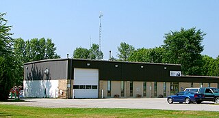
North Gower is a small village in eastern Ontario, originally part of North Gower Township, now part of the city of Ottawa. Surrounding communities include Richmond, Kemptville, Kars and Manotick. Public high school students in this area go to South Carleton High School in Richmond. Elementary school students go to Marlborough Public School in North Gower.

Big Rideau Lake is a lake in the municipalities of Tay Valley and Drummond/North Elmsley, Lanark County and Rideau Lakes, United Counties of Leeds and Grenville in Eastern Ontario, Canada. The lake is on the border between the two counties, 72 kilometres (45 mi) to the southwest of Ottawa. It is 32 kilometres (20 mi) long and is 6 kilometres (3.7 mi) wide, is much narrower at its northeastern end than at its southwestern end, and is part of the Saint Lawrence River drainage basin. It is the largest lake on the Rideau Canal, which was designated a UNESCO world heritage site in 2007.
King's Highway 31, commonly referred to as Highway 31 and historically known as the Metcalfe Road, was a provincially maintained highway in the Canadian province of Ontario. The 76.93-kilometre (47.80 mi) route connected Highway 2 in Morrisburg with the Chaudière Bridge at the Ontario–Quebec boundary in downtown Ottawa.
Rideau Lakes is a township located within Leeds and Grenville United Counties in Eastern Ontario, Canada. The township was incorporated on 1 January 1998 by amalgamating the former townships of North Crosby, South Crosby, Bastard, South Burgess and South Elmsley with the village of Newboro.

Merrickville–Wolford is a village-status municipality in Eastern Ontario, Canada, located in the United Counties of Leeds and Grenville. It spans both shores of the Rideau River.
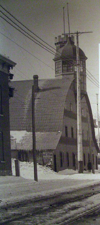
The Rideau Skating Rink was an indoor skating and curling facility located in Ottawa, Ontario, Canada. Consisting of a curling rink and a skating rink, it was one of the first indoor rinks in Canada. The Rideau Rink was scheduled to open on January 10, 1889, but unseasonably mild weather postponed the grand opening to February 1. It opened on January 25, 1889 for select V.I.P.s although this was a misunderstanding and should not have denied entry to season ticket holders. It was located on Theodore Street, at Waller Street, at the present location of the Arts Hall of the University of Ottawa, near the Rideau Canal.
Highway 17B was formerly the designation for six business routes of Highway 17, the main route of the Trans-Canada Highway through the Canadian province of Ontario. Each generally followed the original route of Highway 17 through the town or city that it served, and was subsequently given the Highway 17B designation when a newer bypass route was constructed to either reduce traffic pressure on the local street network, or provide a better thoroughfare that avoided urban areas altogether.
King's Highway 43, also known as Highway 43, was a provincially maintained highway in the Canadian province of Ontario. On January 1, 1998, the entire route was transferred to the county that each section resided in, resulting in the current designations of Lanark County Road 43, Leeds and Grenville Road 43 and Stormont, Dundas and Glengarry Road 43. Highway 43 ran somewhat parallel to and between Highway 401 and Highway 417 from Highway 7 in Perth to Highway 34 in Alexandria, passing through several small towns along the way. At 154.2 km (95.8 mi), it is the longest highway in Ontario to be decommissioned entirely during the mass transfer of Highways in 1997 and 1998.
King's Highway 42, commonly referred to as Highway 42, was a provincially maintained highway in the Canadian province of Ontario. The 52.8-kilometre (32.8 mi)-long route connected Highway 29 at Forthton with the town of Westport, intersecting Highway 15 en route. Highway 42 was assumed in 1935, and aside from paving the partially gravelled road, generally remained unchanged throughout its existence. In 1997, it was decommissioned and transferred to the United Counties of Leeds and Grenville, subsequently being redesignated as Leeds and Grenville County Road 42.
King's Highway 29, commonly referred to as Highway 29, was a provincially maintained highway in the Canadian province of Ontario. The 52.29-kilometre (32.49 mi) route connected Highway 2 in downtown Brockville with Highway 15 south of Smiths Falls. Between those larger settlements, it provided access to the communities of Forthton, Addison, Frankville, Toledo and Newbliss.

Lucille Collard is a Canadian politician who has been a member of Provincial Parliament (MPP) since 2020. A member of the Ontario Liberal Party, Collard represents Ottawa—Vanier in the Legislative Assembly of Ontario.

