
The Hudson's Bay Company is a Canadian retail business group. A fur trading business for much of its existence, it became the largest and oldest corporation in Canada, and now owns and operates retail stores across the country. The company's namesake business division is Hudson's Bay, commonly referred to as The Bay.

The Kenogami River is a river in the James Bay drainage basin in Thunder Bay and Cochrane districts in Northern Ontario, Canada, which flows north from Long Lake near Longlac to empty into the Albany River. The river is 320 kilometres (199 mi) in length and its name means "long water" in the Cree language. A portion of the river's headwaters have been diverted into the Lake Superior drainage basin.
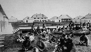
Treaty Five is a treaty between Queen Victoria and Saulteaux and Swampy Cree non-treaty band governments and peoples around Lake Winnipeg in the District of Keewatin. Much of what is today central and northern Manitoba was covered by the treaty, as were a few small adjoining portions of the present-day provinces of Saskatchewan and Ontario.
Nipigon is a township in Thunder Bay District, Northwestern Ontario, Canada, located along the west side of the Nipigon River and south of the small Helen Lake running between Lake Nipigon and Lake Superior. Lake Nipigon is located approximately 25 kilometres (16 mi) north of Nipigon. Located at latitude 49.0125° N, Nipigon is the northernmost community on the Great Lakes.
Riding Mountain National Park is a national park in Manitoba, Canada. The park is located within Treaty 2 Territory and sits atop the Manitoba Escarpment. Consisting of a protected area 2,969 km2 (1,146 sq mi), the forested parkland stands in sharp contrast to the surrounding prairie farmland. It was designated a national park because it protects three different ecosystems that converge in the area; grasslands, upland boreal and eastern deciduous forests. It is most easily reached by Highway 10 which passes through the park. The south entrance is at the townsite of Wasagaming, which is the only commercial centre within the park boundaries.

Cumberland House is a community in Census Division No. 18 in northeast Saskatchewan, Canada on the Saskatchewan River. It is the oldest community in Saskatchewan and has a population of about 2,000 people. Cumberland House Provincial Park, which provides tours of an 1890s powder house built by the Hudson's Bay Company, is located nearby.
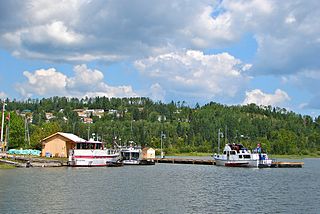
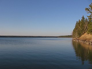
Norway House is a population centre of over 5,000 people, some 30 km (19 mi) north of Lake Winnipeg, on the bank of the eastern channel of Nelson River, in the province of Manitoba, Canada. The population centre shares the name Norway House with the northern community of Norway House and Norway House 17, a First Nation reserve of the Norway House Cree Nation. Thus, Norway House has both a Chief and a Mayor.
Elphinstone is an unincorporated community recognized as a local urban district in the Rural Municipality of Yellowhead in the Canadian province of Manitoba. It is located northwest of Brandon, Manitoba and is on Highway 45. It is on the west bank of the Little Saskatchewan River.
Treaty 2 was entered in to on 21 August 1872 at Manitoba House, Rupertsland, with representatives of the Queen of Great Britain and Ireland. The original Anishinaabe, who were present, constitute Treaty 2 today. It is known that many of the chiefs and leaders within the territory were at the early gathering and after the treaty was agreed to. Those who were not present were represented through Metis until they indicated where they wished their farming reserves to be established. The treaty reaffirmed the inherent rights that the Anishinaabe had prior to European contact, located where southwestern Manitoba is today and a small part of southeastern Saskatchewan.
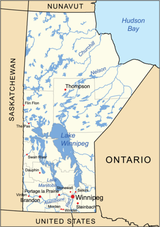
The geography of Manitoba addresses the easternmost of the three prairie Canadian provinces, located in the longitudinal centre of Canada. Manitoba borders on Saskatchewan to the west, Ontario to the east, Nunavut to the north, and the American states of North Dakota and Minnesota to the south. Although the border with Saskatchewan appears straight on large-scale maps, it actually has many right-angle corners that give the appearance of a slanted line. In elevation, Manitoba ranges from sea level on Hudson Bay to 2727 ft (831 m) on top of Baldy Mountain. The northern sixty percent of the province is on the Canadian Shield. The northernmost regions of Manitoba lie permafrost, and a section of tundra bordering Hudson Bay.
The Manitoba Escarpment, or the Western Manitoba Uplands, are a range of hills along the Saskatchewan-Manitoba border. The eastern slopes of the range are considered to be a scarp. They were created by glacial scouring and formed the western shore of prehistoric Lake Agassiz.
Constance Lake First Nation is an Oji-Cree First Nations band government located on the shores of Constance Lake near Hearst, Cochrane District in northeastern Ontario, Canada. It is directly north of the community of Calstock along a continuation of Ontario Highway 663. Constance Lake First Nation is home to close to 1605 members of Cree and Ojibway with approximately 820 living on reserve. The reserves, Constance Lake 92 and English River 66, total 7,686 acres (3,110 ha) in size.

Peter Fidler was a British surveyor, map-maker, fur trader and explorer who had a long career in the employ of the Hudson's Bay Company (HBC) in what later became Canada. He was born in Bolsover, Derbyshire, England and died at Fort Dauphin in present-day Manitoba. He married Mary (Methwewin) Mackagonne, a Cree woman, and together they had 14 children.
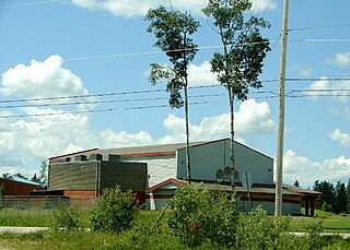
Keeseekoowenin Ojibway First Nation is a First Nations community primarily located on Keeseekoowenin 61, situated near Elphinstone, Manitoba, south of Riding Mountain National Park.
Fisher River is a Cree First Nations reserve located approximately 193 km north of Manitoba's capital city, Winnipeg. The Fisher River Cree Nation is composed of two reserves; Fisher River 44 and Fisher River 44A. The reserve population is 1945, the off reserve population is 1934 for a total of 3879 band members as of June 2017. Fisher River is 15,614 acres.
The Norway House Cree Nation is based at Norway House, Manitoba, which is on the Playgreen Lake section of the Nelson River system. The people are Swampy Cree from the Rocky Cree band government. They are in possession of a number of reserves, but population is centered at IR Norway House 17 (06392). There are over 8300 members living on-reserve with another 1900 plus members at various locations off-reserve. The 2016 Census reported an official population of 7,927 inhabitants at Norway House 17 up from 7,758 in 2011.
George Flett was a Presbyterian missionary in what is now Manitoba, Canada. Flett was of Orkney and Cree descent. As a young man he farmed on the White Horse Plains, led a gold exploration party to Edmonton and then became the first post master for the Hudson's Bay Company at Fort Victoria, Alberta. Flett was an interpreter to the first Presbyterian mission to the northwest between 1866 and 1867. After serving as a delegate in the provisional government of Louis Riel during the Red River Rebellion, he became a missionary among the Ojibwa of Okanese Reserve, serving from 1873 to 1895.
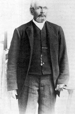
Keeseekoowenin was a First Nations leader during the period when Canada was expanding into the prairie provinces of Manitoba, Saskatchewan and Alberta.

La Cloche Provincial Park is a provincial park at the boundary of Algoma and Sudbury Districts in Ontario, Canada. The park consists of an unspoiled section of the La Cloche Mountains that stretch along the North Channel of Georgian Bay, as well as several islands in the channel.
