Rietmolen | |
|---|---|
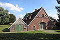
 Church of Rietmolen | |
 Rietmolen Location in the province of Gelderland  Rietmolen Rietmolen (Netherlands) | |
| Coordinates: 52°5′14″N6°27′28″E / 52.08722°N 6.45778°E | |
| Country | Netherlands |
| Province | Gelderland |
| Municipality | Berkelland |
| Area | |
• Total | 12.24 km2 (4.73 sq mi) |
| Elevation | 19 m (62 ft) |
| Population (2021) [1] | |
• Total | 1,020 |
| • Density | 83.3/km2 (216/sq mi) |
| Time zone | UTC+1 (CET) |
| • Summer (DST) | UTC+2 (CEST) |
| Postal code | 7165 [1] |
| Dialing code | 0545 |
Rietmolen is a village in the eastern Netherlands. It is located in the municipality of Berkelland, Gelderland.
It was first mentioned in the 1630s as Rytmuelerbrugh, and means "windmill along a stream". [3] Since 1712, the inn Reetmölle was used as a Catholic church. In 1835, a real church was built. [4] In 1931, construction began on a new church. It was finished in 1933, and has a 45 metres (148 ft) tall slender tower which resembles a minaret. [5]