Ruurlo

Last updated
Ruurlo
Huize Ruurlo Castle Netherlands.JPG
Ruurlo Castle
Ruurlo vlag.svg
Ruurlo wapen.svg
2010-NL-P05-Gelderland-positiekaart-gemnamen.jpg
Red pog.svg
Ruurlo
Location in the province of Gelderland
Netherlands location map.svg
Red pog.svg
Ruurlo
Ruurlo (Netherlands)
Coordinates: 52°5′14″N6°27′28″E / 52.08722°N 6.45778°E / 52.08722; 6.45778
Country Netherlands
Province Gelderland
Municipality Berkelland
Area
[1]
  Total55.02 km2 (21.24 sq mi)
Elevation
[2]
17 m (56 ft)
Population
 (2021) [1]
  Total7,730
  Density140/km2 (360/sq mi)
Time zone UTC+1 (CET)
  Summer (DST) UTC+2 (CEST)
Postal code
7261 [1]
Dialing code 0573

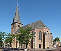
Ruurlo is a village and former municipality in the province of Gelderland in the eastern part of the Netherlands.

Contents

The town has a station on the Zutphen to Winterswijk railway line, and is served by trains every half-hour in both directions. In the evening there is an hourly service.

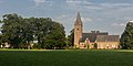
Ruurlo Castle lies just outside the town and is a popular place for weddings. The castle was used as the town hall until 1 January 2005, when the municipality Ruurlo merged with the municipalities of Borculo, Neede and Eibergen into the municipality of Berkelland.

History

It was first mentioned in the 1180s as Ritherlo, and means "catlle near forest". [3] The village developed in the Middle Ages around Ruurlo Castle. The castle was first mentioned in 1326. It was enlarged in 1571, 1627 and 1727. The gardens date from 1801. After the 1984 restoration was completed, it served as town hall. [4]

The Dutch Reformed Church has 14th century elements. The tower dates from the late-15th century and was restored in 1793 and 1894. The Catholic Saint Willibrord was completed in 1871, and was designed by Pierre Cuypers. [4] In 1840, it was home to 419 people. [5]

The Ruurlo railway station opened in 1878. The building was demolished in 1982, and replaced by a simple bus stop which was removed in 2000. [6] The saw and gristmill Agneta dates from 1851. It was originally an oil mill, but was redesigned in 1917. The mill is sometimes used for sawing, however it is usually performed with an electric engine. [7]

Former population centres

Brinkmanshoek, De Bruil, De Haar, Heurne, Mariënvelde, Ruurlo and Veldhoek.

Related Research Articles

<span class="mw-page-title-main">Vorden</span> Former municipality and village in Gelderland, Netherlands

Vorden is a former municipality and a town in the eastern Netherlands, about 10 kilometres south-east of Zutphen. On 1 January 2005 the municipality merged with Hummelo en Keppel, Steenderen, Hengelo en Zelhem, to form the new municipality Bronckhorst.

<span class="mw-page-title-main">Akkrum</span> Village in Friesland, Netherlands

Akkrum is a village in the Dutch province of Friesland. It is located in the municipality Heerenveen, about 17 km south of the city of Leeuwarden.

<span class="mw-page-title-main">Sexbierum</span> Village in Friesland, Netherlands

Sexbierum is a village in the municipality of Waadhoeke, in the central north of the Netherlands.

<span class="mw-page-title-main">Hoogwoud</span> Small city in North Holland, Netherlands

Hoogwoud is a small city in the Dutch province of North Holland. It is a part of the municipality of Opmeer, and lies about 9 kilometres (5.6 mi) northeast of Heerhugowaard.

<span class="mw-page-title-main">Olst</span> Town in Overijssel, Netherlands

Olst is a town in the Dutch province of Overijssel, about 8 km north of Deventer. It is located in the municipality of Olst-Wijhe.

<span class="mw-page-title-main">Krabbendijke</span> Village in Zeeland, Netherlands

Krabbendijke is a village in the Dutch province of Zeeland. It is located in the municipality of Reimerswaal, about 6 km southeast of the town of Kruiningen.

<span class="mw-page-title-main">Stiens</span> Village in Friesland, Netherlands

Stiens is a town in the municipality of Leeuwarden, Netherlands. As of January 2017, the town has a population of about 7,545. Between 1944 and 2018, it was the capital of the municipality of Leeuwarderadeel.

<span class="mw-page-title-main">Heeze</span> Town in North Brabant, Netherlands

Heeze is a town in the Dutch province of North Brabant. It is located in the municipality of Heeze-Leende, about 9 km southeast of Eindhoven.

<span class="mw-page-title-main">Ouddorp</span> Village in South Holland, Netherlands

Ouddorp is a village in the Dutch province of South Holland. It is part of the municipality of Goeree-Overflakkee. It is often referred to as Ouddorp aan Zee to promote itself as a seaside resort, because the village has an 18 kilometres (11 mi) long beach which is the longest of the Netherlands.

<span class="mw-page-title-main">'s-Heer Arendskerke</span> Village in Zeeland, Netherlands

's-Heer Arendskerke is a village in the municipality of Goes in the south-western Netherlands.

<span class="mw-page-title-main">Oud-Zuilen</span> Village in Utrecht, Netherlands

Oud-Zuilen is a village in the Dutch province of Utrecht. It is a part of the municipality of Stichtse Vecht, and lies about 4 km northwest of Utrecht. It is in an area called the "Vechtstreek". Zuylen Castle is located in the village.

<span class="mw-page-title-main">Eanjum</span> Village in Friesland, Netherlands

Eanjum is a village in the Dutch province of Friesland. It is located in the municipality Noardeast-Fryslân and had, as of January 2017, a population of 1136.

<span class="mw-page-title-main">Gasselte</span> Village in Drenthe, Netherlands

Gasselte is a village in the Dutch province of Drenthe. Located in the municipality of Aa en Hunze, it is situated about 16 km (9.9 mi) east of Assen. In 2021, it had a population of 1,770.

<span class="mw-page-title-main">'s-Gravenpolder</span> Village in Zeeland, Netherlands

's-Gravenpolder is a village in the Dutch province of Zeeland. It is a part of the municipality of Borsele, and lies about 21 kilometres east of Middelburg.

<span class="mw-page-title-main">Hoevelaken</span> Town in Gelderland, Netherlands

Hoevelaken is a town in the Dutch province of Gelderland. It is a part of the municipality of Nijkerk, and lies about 5 km east of Amersfoort.

<span class="mw-page-title-main">Dreumel</span> Village in Gelderland, Netherlands

Dreumel is a village in the Dutch province of Gelderland. It is a part of the municipality of West Maas en Waal, and lies about 4 km south of Tiel.

<span class="mw-page-title-main">Kloetinge</span> Village in Zeeland, Netherlands

Kloetinge is a village in the Dutch province of Zeeland. It is located in the municipality of Goes, on the eastern side of the city.

<span class="mw-page-title-main">Waarde</span> Village in Zeeland, Netherlands

Waarde is a village in the Dutch province of Zeeland. It is located in the municipality of Reimerswaal, about 4 km southeast of Kruiningen.

<span class="mw-page-title-main">Eerbeek</span> Town in Gelderland, Netherlands

Eerbeek is a town in the municipality of Brummen in the province of Gelderland in the Netherlands. Eerbeek was first mentioned in 1046 as Erbeke. In the 18th century, Eerbeek became a centre of paper production. Due to its proximity to the Veluwezoom National Park, Eerbeek is popular with tourists.

<span class="mw-page-title-main">Tzummarum</span> Village in Friesland, Netherlands

Tzummarum is a village in Waadhoeke municipality in the province of Friesland, the Netherlands. It had a population of around 1,414 in January 2014.

References

  1. 1 2 3 "Kerncijfers wijken en buurten 2021". Central Bureau of Statistics. Retrieved 20 March 2022.
  2. "Postcodetool for 7261AA". Actueel Hoogtebestand Nederland (in Dutch). Het Waterschapshuis. Retrieved 20 March 2022.
  3. "Ruurlo - (geografische naam)". Etymologiebank (in Dutch). Retrieved 20 March 2022. 1118 document was a forgery
  4. 1 2 Ronald Stenvert & Sabine Broekhoven (2000). "Ruurlo" (in Dutch). Zwolle: Waanders. p. 286. ISBN   90 400 9406 3 . Retrieved 20 March 2022.
  5. "Ruurlo". Plaatsengids (in Dutch). Retrieved 20 March 2022.
  6. "Station Ruurlo". Stationsweb (in Dutch). Retrieved 20 March 2022.
  7. "Agneta". Molendatabase (in Dutch). Retrieved 20 March 2022.

52°05′N6°27′E / 52.083°N 6.450°E / 52.083; 6.450