Characteristics
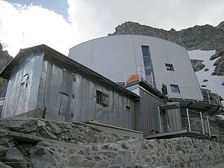
It is situated in the frazione of Chiappera, in the upper Maira Valley at approximately 1,650 metres above sea-level on the right bank of the main valley floor of the Maurin river (the upper stretch of the Maira river). Opened in 1982, has been renewed during 2010 and has now 26 sleeping accommodations in the refuge and an area for camping.
It is opened from 20 December to 1 November.
The Rifugio Campo Base is an excellent point of departure and can be a useful base for different itineraries: the GTA (Grande Traversata delle Alpi), the Via Alpina, Percorsi Occitani, Tour of Chambeyron, Sentiero Roberto Cavallero. It is situated at the crossing between the red and the blue trail of the Via Alpina

Alta Via 1 is a 125-kilometre-long high-level public footpath which runs through the eastern Dolomites in Italy. It is also known as the Dolomite High Route 1. It passes through some of the finest scenery in the Dolomites. The path runs south from Pragser Wildsee, near Toblach, to Belluno. Prags can be accessed by bus, and Belluno has both train and bus services.
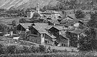
Prazzo is comune of the province of Cuneo, in Piedmont, northern Italy.
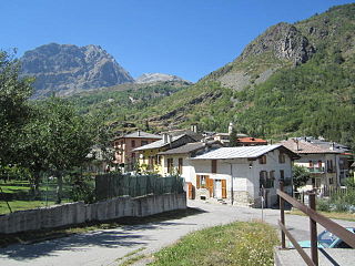
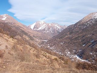
Acceglio is a comune (municipality) in the Province of Cuneo in the Italian region Piedmont. It is located above Prazzo in the upper Valle Maira about 90 kilometres (56 mi) southwest of Turin and about 45 kilometres (28 mi) west of Cuneo, on the border with France.
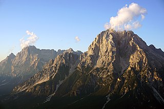
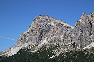
Monte Antelao is the highest mountain in the eastern Dolomites in northeastern Italy, southeast of the town of Cortina d'Ampezzo, in the region of Cadore. The Monte Antelao is an ultra-prominent peak (Ultra).

Monte Cusna is the 2nd highest peak in the northern Apennines after Monte Cimone. But, it is much steeper and more remote.
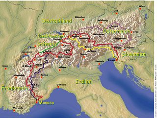
The Via Alpina is a network of five long-distance hiking trails across the alpine regions of Slovenia, Austria, Germany, Liechtenstein, Switzerland, Italy, France, and Monaco. The longest of trails is the red trail, whose termini are in Trieste and Monaco.
The Val Chisone is one of the Occitan valleys of western Piedmont, situated in the Cottian Alps in the Metropolitan City of Turin in north-west Italy.

Pizzo Coca is a mountain that straddles the Val Seriana and the Valtellina in Lombardy, Italy. It is the highest peak in the Bergamo Alps. Its height is 3,050 metres with a prominence height of 1,878 metres and a saddle of 1,172 metres. A post-glacial valley exists near a point called Ometto in sassi at 2,400 meters.

Rifugio Vittorio Sella is a mountain hut in the Alps in Aosta Valley, Italy.

The Torino Hut is a high mountain refuge in the Alps in northwestern Italy. Located near the border with France, it is about 15 km (10 mi) southwest of Mont Dolent, the tripoint with Switzerland. The refuge is in the Mont Blanc massif above the town of Courmayeur in the Aosta Valley, Italy. It can be most easily accessed from the Italian side by the Skyway Monte Bianco cable car from La Palud in Courmayeur, with a change at the Pavilion du Mont Fréty. It can also be reached from Chamonix via the Aiguille du Midi, either by cable car which crosses the massif, or by a long crossing of the Glacier du Gèant. The refuge lies nearly directly above the 11.6 km (7.2 mi) Mont Blanc Tunnel, which passes deep underground, and connects Courmayeur to Chamonix.
Mount Faloria is a mountain in the Alps of northern Italy, located in the Dolomites near Cortina d'Ampezzo. It has an altitude of 2,352 metres (7,717 ft) and lies in close proximity to Sorapiss. It hosted the men's giant slalom event of the 1956 Winter Olympics, won by Toni Sailer of Austria, the first of three wins in his gold medal sweep. There is a mountain refuge at the summit, Rifugio Faloria.
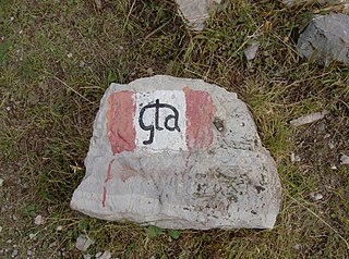
The Grande Traversata delle Alpi (GTA) is a long-distance hiking trail in the Italian region of Piedmont. In about 1,000 kilometres (620 mi) and 55 day hikes, it runs through the arc formed by the western Alps from the Pennine Alps through the Graian and Cottian Alps to the Maritime and Ligurian Alps. There are a number of transverse valleys along the route. Day hikes typically connect high-lying valley communities with each other via historic pass routes.
The Gonella Hut is a high elevation mountain hut in the Aosta Valley in the Mont Blanc massif area of the Alps. It lies at an elevation of 3071 metres, above Val Veny near Courmayeur in Italy. The refuge is located on the Italian 'normal route' to Mont Blanc.

The Lechquellen Mountains or Lechquellen range is a small mountain group within the Northern Limestone Alps of the Eastern Alps. It lies entirely within the Austrian state of Vorarlberg and includes the upper reaches of the river Lech with its headstreams in a horseshoe shape as well as the Upper Großwalsertal valley.

The Grande Aiguille Rousse is a mountain peak of the Graian Alps in Savoie, France, situated between the Maurienne and Tarentaise valleys near the Italian border. Reaching an altitude of 3,482 meters, it exceeds its junior to the west, the Petite Aiguille Rousse, by just 50 m (160 ft). Not far from Levanna, the Grande Aiguille Rousse overlooks Serrù Lake and the Gran Paradiso National Park in Italy.
Lagazuoi is a mountain in the Dolomites of northern Italy, lying at an elevation of 2,835 metres (9,301 ft), about 18 kilometres (11 mi) southwest by road from Cortina d'Ampezzo in the Veneto Region. The mountain is part of the Ampezzo Dolomites Natural Park.

Sorapiss, also referred to as Sorapis or Punta Sorapiss, is a mountain in the Dolomites within the Veneto region of northern Italy. Situated in the comune of Cortina d'Ampezzo, it has an elevation of 3,205 metres (10,515 ft). In its vicinity is a mountain pass of the same name, as well as Sorapiss Lake, at the foot of the mountain. The mountain range is part of the Ampezzo Dolomites Natural Park.

Rifugio Sanremo is a refuge in the Ligurian Alps in Italy. Located at 2,054 m, is the highest mountain hut in Liguria.

Col Visentin is a mountain in the Bellunes Alps, in the Veneto region of Italy, which marks a geographical border point between the province of Belluno and the province of Treviso.
The Campo Moro dams are a pair of hydroelectric-gravity dams situated in Lanzada, in the province of Sondrio, Lombardy. The two dams are called Alpe Gera dam and Campo Moro dam. Alpe Gera, the largest of the pair, was constructed with approximately 1,800,000 m³ of concrete to create the Alpe Gera reservoir. The lower dam, Campo Moro, was created to form the Campo Moro reservoir.

