Rijsbergen

Last updated
Rijsbergen
Rijsbergen, de Sint Bavokerk 0879WN037 en kerkhof 0879WN038 foto9 2015-06-17 13.16.jpg
St Bavo Church
2010-NL-P10-Noord-Brabant-positiekaart-gemnamen.jpg
Red pog.svg
Rijsbergen
Location in the province of North Brabant in the Netherlands
Netherlands location map.svg
Red pog.svg
Rijsbergen
Rijsbergen (Netherlands)
Coordinates: 51°31′1″N4°41′46″E / 51.51694°N 4.69611°E / 51.51694; 4.69611
Country Netherlands
Province North Brabant
Municipality Zundert
Area
[1]
  Total35.36 km2 (13.65 sq mi)
Elevation
[2]
8 m (26 ft)
Population
 (2021) [1]
  Total6,655
  Density190/km2 (490/sq mi)
Time zone UTC+1 (CET)
  Summer (DST) UTC+2 (CEST)
Postal code
4891 [1]
Dialing code 076

Rijsbergen a town in the municipality of Zundert in the southern Netherlands.

In the town used to be an AC (Aanmeldcentrum, i.e. Asylum Request Center).

Until 1997 Rijsbergen was an independent municipality, after which it was added to Zundert.

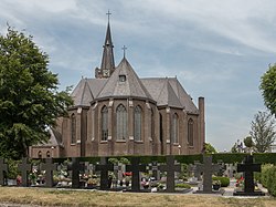
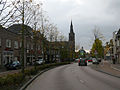
The skyline of Rijsbergen is dominated by the neo-Gothic Roman Catholic church of Saint Bavo, which was built in 1918 as a replacement of a smaller fourteenth-century church. The church is situated in the town centre and is flanked by the former town hall, which has been transformed into a museum. Furthermore, in the outskirts of Rijsbergen a successful Garden Centre can be found named: "De Bosrand". A deeply loved place by the locals.

The countryside around Rijsbergen is dotted with eleven shrines devoted to the Virgin Mary. They were built after the Second World War as a thanksgiving for surviving the war relatively undamaged.

Related Research Articles

<span class="mw-page-title-main">Zutphen</span> City and municipality in Gelderland, Netherlands

Zutphen is a city and municipality located in the province of Gelderland, Netherlands. It lies some 30 km northeast of Arnhem, on the eastern bank of the river IJssel at the point where it is joined by the Berkel. First mentioned in the 11th century, the place-name appears to mean "south fen". In 2005, the municipality of Zutphen was merged with the municipality of Warnsveld, retaining its name. In 2021, the municipality had a population of 48,111.

<span class="mw-page-title-main">Zundert</span> Municipality in North Brabant, Netherlands

Zundert is a municipality and town in the south of the Netherlands bordering Belgium, in the province of North Brabant.

<span class="mw-page-title-main">Essen, Belgium</span> Municipality in Flemish Community, Belgium


Essen is a town and municipality in the Belgian province of Antwerp, notable for being bordered by the Netherlands on three sides. As of September 2022, it has a population of 19,029 residents. The town belongs to both the electoral canton of Brecht and the judicial canton of Kapellen and is situated in the region of Noorderkempen.

<span class="mw-page-title-main">Ludza</span> Town in Ludza Municipality, Latvia

Ludza is a town in the Latgale region of eastern Latvia. Ludza is the oldest town in Latvia and this is commemorated by a key in its coat of arms. Ludza is the administrative centre of Ludza Municipality that is located nearby the Russian border. The population as of 2020 was 7,667.

<span class="mw-page-title-main">Kuldīga</span> Town in Latvia

Kuldīga is a town in the Courland region of Latvia, in the western part of the country. It is the center of Kuldīga Municipality with a population of approximately 13,500.

<span class="mw-page-title-main">Achtmaal</span> Village in North Brabant, Netherlands

Achtmaal is a village the south of the Netherlands. It is located in Zundert, North Brabant, near the border with Belgium.

<span class="mw-page-title-main">Mäntsälä</span> Municipality in Uusimaa, Finland

Mäntsälä is a municipality in the province of Southern Finland, and is part of the Uusimaa region. It has a population of 20,957 (31 December 2023) and covers an area of 596.11 square kilometres (230.16 sq mi) of which 15.26 km2 (5.89 sq mi) is water. The population density is 36.08 inhabitants per square kilometre (93.4/sq mi). The municipality is unilingually Finnish. Mäntsälä is one of three municipalities in the Uusimaa region that do not have a Swedish name; the others are Nurmijärvi and Askola.

<span class="mw-page-title-main">Mühlhausen</span> Town in Thuringia, Germany

Mühlhausen is a town in the north-west of Thuringia, Germany, 5 km north of Niederdorla, the country's geographical centre, 50 km north-west of Erfurt, 65 km east of Kassel and 50 km south-east of Göttingen.

<span class="mw-page-title-main">Deloraine, Manitoba</span> Place in Manitoba, Canada

Deloraine is an unincorporated urban community in the Municipality of Deloraine – Winchester within the Canadian province of Manitoba that held town status prior to January 1, 2015. It is situated near the Turtle Mountains in the southwestern corner of the province. Located in the Westman Region, the community is 100 km (62 mi) south of Brandon. Deloraine originally incorporated as a village in 1904 and then as a town in 1907. Its town status was relinquished in 2015 when it amalgamated with the Rural Municipality of Winchester.

<span class="mw-page-title-main">Krnov</span> Town in the Czech Republic

Krnov is a town in Bruntál District in the Moravian-Silesian Region of the Czech Republic. It has about 23,000 inhabitants.

<span class="mw-page-title-main">Billund, Denmark</span> Town in Southern Denmark, Denmark

Billund is a town in Jutland, Denmark. With a population of 7,049, Billund is the second largest town in Billund Municipality, behind the municipal seat of Grindsted. It is located approximately 13 kilometers east of Grindsted and 27 kilometers west of Vejle.

<span class="mw-page-title-main">Sokolov, Czech Republic</span> Town in the Czech Republic

Sokolov is a town in the Karlovy Vary Region of the Czech Republic. It has about 22,000 inhabitants.

<span class="mw-page-title-main">Alūksne</span> Town in Latvia

Alūksne is a town on the shores of Lake Alūksne in northeastern Latvia near the borders with Estonia and Russia. It is the seat of the Alūksne municipality. Alūksne is the highest elevated Latvian city, located in East Vidzeme Upland at 217 m above sea level. The high elevation of the city affects the social and physical arrangement of the place.

<span class="mw-page-title-main">Zábřeh</span> Town in Olomouc, Czech Republic

Zábřeh is a town in Šumperk District in the Olomouc Region of the Czech Republic. It has about 13,000 inhabitants.

<span class="mw-page-title-main">Berlicum</span> Place in North Brabant, Netherlands

Berlicum is a town in the south of the Netherlands, located in North Brabant's Meierij region near the city of 's-Hertogenbosch and the river Aa. The town was most likely founded between 600 and 700 AD. It was a municipality along with the village of Middelrode until a large-scale municipal reorganisation in 1996, when Berlicum and neighbouring Den Dungen merged with the municipality of Sint-Michielsgestel. In 2009, Berlicum had 9,743 inhabitants.

<span class="mw-page-title-main">Volyně</span> Town in South Bohemian, Czech Republic

Volyně is a town in Strakonice District in the South Bohemian Region of the Czech Republic. It has about 3,000 inhabitants. The historic town centre is well preserved and is protected by law as an urban monument zone.

<span class="mw-page-title-main">Dobřany</span> Town in Plzeň, Czech Republic

Dobřany is a town in Plzeň-South District in the Plzeň Region of the Czech Republic. It has about 6,400 inhabitants. The historic town centre is well preserved and is protected by law as urban monument zone.

<span class="mw-page-title-main">Gulbene</span> Town in Latvia

Gulbene is a town in northeastern Latvia. It is an administrative center of Gulbene Municipality.

<span class="mw-page-title-main">De Akkermolen</span> Dutch monumental windmill

De Akkermolen is a 17th-century windmill in Zundert, Netherlands. Built around 1605 to replace an earlier windmill, it was used as a gristmill until it was severely damaged in 1950. The mill was bought by the local government and restored in 1961, and it was listed as a national heritage site in 1974.

<span class="mw-page-title-main">Elverum (town)</span> Town in Eastern Norway, Norway

is a town in Elverum Municipality in Innlandet county, Norway. The town is the administrative centre of the municipality. It is located in the western part of the municipality along the river Glomma, about 30 kilometres (19 mi) east of the town of Hamar. The town is the regional centre for commerce and industry for the middle Østerdalen valley and the northern part of Solør. The old village of Elverum has grown over the years and in 1996, the municipal council granted Elverum town status.

References

  1. 1 2 3 "Kerncijfers wijken en buurten 2021". Central Bureau of Statistics. Retrieved 19 April 2022.
  2. "Postcodetool for 4891AA". Actueel Hoogtebestand Nederland (in Dutch). Het Waterschapshuis. Retrieved 19 April 2022.