When the original Mount Lyell railway line was being built, it was the location of some significant landslips.[1] In the time of operations of the Mount Lyell railway landslips continued.[2][3][4]
In the event of wildfires in the adjacent district, with little to prevent fires affecting the railway line and Rinadeena structures, losses were inevitable in the past.[5]
It is the highest point on the railway line, with Abt mechanisms on the steam locomotives required from either side of operations.[7][8]
The Abt fittings on the track proceed upward from Hall's Creek on the Queenstown side, and from Rinadeens downward to Dubbil Barril on the Regatta Point side.[9]
↑ "WESTERN NEWS". Launceston Examiner. Vol.LIX, no.215. Tasmania, Australia. 8 September 1899. p.6. Retrieved 2 June 2016– via National Library of Australia.
↑ "ISOLATED TOWN". Recorder. No.9, 107. South Australia. 19 July 1928. p.4. Retrieved 3 June 2016– via National Library of Australia.
↑ "DEVELOPMENT OF THE WEST COAST". The Mercury. Vol.CXLVII, no.20, 882. Tasmania. 28 October 1937. p.12. Retrieved 3 June 2016– via National Library of Australia. – note photograph of rinadeena railway track in right hand side of view, photo by W J Rowlands
↑ West Coast Wilderness Railway (Tas.) (2008), Abt system, West Coast Wilderness Railway, retrieved 12 June 2016
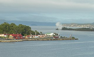
Strahan is a small town and former port on the west coast of Tasmania. It is now a significant locality for tourism in the region.
The Lyell Highway is a highway in Tasmania, running from Hobart to Queenstown. It is the one of two transport routes that passes through the West Coast Range, the other being the B28 Anthony Road.
Mount Lyell Mining and Railway Company was a Tasmanian mining company formed on 29 March 1893, most commonly referred to as Mount Lyell. Mount Lyell was the dominant copper mining company of the West Coast from 1893 to 1994, and was based in Queenstown, Tasmania.
Regatta Point is the location of a port and rail terminus on Macquarie Harbour.
The North Mount Lyell disaster refers to a fire that broke out on 12 October 1912 at the Mount Lyell Mining and Railway Company operations on the West Coast of Tasmania, killing 42 miners. The mine had been taken over from the North Mount Lyell Company in 1903.
Trial Harbour is a rural locality in the local government area (LGA) of West Coast in the North-west and west LGA region of Tasmania. The locality is about 20 kilometres (12 mi) south-west of the town of Zeehan. The 2016 census has a population of 24 for the state suburb of Trial Harbour.
Gormanston is a town in Tasmania on the slopes of Mount Owen, above the town of Queenstown in Tasmania's West Coast. In the 2016 census, Gormanston had a population of 17.
The North Mount Lyell Railway was built to operate between the North Mount Lyell mine in West Coast Tasmania and Pillinger in the Kelly Basin of Macquarie Harbour.
The Queen River, part of the King River catchment, is a minor perennial river located in the West Coast region of Tasmania, Australia. It is notable for its high level of pollution caused by mining runoff which has led the river to be uninhabitable to life.
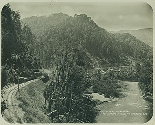
The history of the railways on the West Coast of Tasmania has fascinated enthusiasts from around the world, because of the combination of the harsh terrain in which the railways were created, and the unique nature of most of the lines.
The Strahan–Zeehan Railway, also known as the "Government Railway", was a railway from Strahan to Zeehan on the west coast of Tasmania.
Teepookana was a short lived port, community and railway stopping place on the southern bank of the King River, in Western Tasmania.
Iron Blow was the site of the earliest major mining venture at Mount Lyell on the west coast of Tasmania, Australia in 1883.
The West Coast Wilderness Railway is a reconstruction of the Mount Lyell Mining and Railway Company Mount Lyell railway in Western Tasmania between Queenstown and Regatta Point, Strahan. The railway is significant because of its Abt rack system to conquer the mountainous terrain through rainforest, with original locomotives still operating on the railway today. Now operating as a tourist experience with a focus on sharing the history of Tasmania's West Coast, the original railway began operations in 1897 as the only link between Queenstown and the port of Strahan.
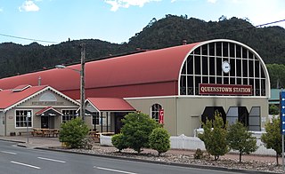
Queenstown in Western Tasmania has had two railway stations. The original was built for the railway built for the Mount Lyell Mining and Railway Company, and lasted until the closing of the railway line in 1962. The newer station was built for the re-built railway, the West Coast Wilderness Railway.
Dubbil Barril is a stopping place and railway station on the northern bank of the King River and West Coast Wilderness Railway in Tasmania.
Lynchford is a locality and was a stopping place on the Mount Lyell railway to Strahan, to the south of Queenstown in the Queen River valley.
Zeehan Highway is a road between Zeehan and Queenstown in Western Tasmania.
Queenstown to Strahan road is a road that connects Queenstown with Strahan in Western Tasmania.
The term Mount Lyell Railway was one of the terms used for the railway operated by the Mount Lyell Mining and Railway Company between 1899 and 1963.
This page is based on this Wikipedia article Text is available under the CC BY-SA 4.0 license; additional terms may apply. Images, videos and audio are available under their respective licenses.