Related Research Articles

Aitkin County is a county in the U.S. state of Minnesota. As of the 2020 United States Census, the population was 15,697. Its county seat is Aitkin. Part of the Mille Lacs Indian Reservation is in the county. The county was created in 1857 and organized in 1871.
Aitkin is a city in Aitkin County, Minnesota, United States. The population was 2,165 at the 2010 census. It is the county seat of Aitkin County.

The Wapsipinicon River is a tributary of the Mississippi River, approximately 300 miles (480 km) long, starting near the southeastern border of Minnesota and running through northeastern Iowa in the United States. It drains a rural farming region of rolling hills and bluffs north of Waterloo and Cedar Rapids.
The Knife River is a 27.4-mile-long (44.1 km) tributary of the Snake River in east-central Minnesota in the United States. It is one of three streams in Minnesota with this name. Its name is a translation from the Dakota Isaanti. Knife Lake and Santee Sioux are named after this river. In turn Isanti County is named after the Santee Sioux.
Paint Creek is a tributary of the Scioto River, 94.7 miles (152.4 km) long, in south-central Ohio in the United States. Via the Scioto and Ohio Rivers, it is part of the watershed of the Mississippi River. It drains an area of 1,143 square miles (2,960 km2).

The Otter Tail River is a 192-mile-long (309 km) river in the west-central portion of the U.S. state of Minnesota. It begins in Becker County, 40 miles (64 km) southwest of Bemidji. It then flows through a number of lakes and cities in Minnesota, including Many Point Lake, Chippewa Lake, Height of Land Lake, Frazee, the Pine lakes, Rush Lake, Otter Tail Lake and Ottertail, West Lost Lake, Fergus Falls, and Orwell Lake.

The North Fork River or the North Fork of White River is a 109-mile-long (175 km) tributary of the White River, into which it flows near Norfork, Arkansas.

Hay Creek is a small trout stream in southeastern Minnesota. It has its headwaters west of Goodhue and empties into the Mississippi River just to the north of Red Wing. It runs 25.1 miles (40.4 km). Hay Creek was named for the hay meadows near its banks. A railroad once ran along Hay Creek from the claybanks near Goodhue to the pottery and stoneware factories in Red Wing, which also made use of the water from the creek. The railroad was torn up in 1937, but traces such as trestle pilings remain.

The Baptism River is an 8.8-mile-long (14.2 km) river of the U.S. state of Minnesota. The river source is the confluence of the East Branch Baptism River and the West Branch Baptism River just south of the community of Finland.
The Little Willow River is a 26.2-mile-long (42.2 km) tributary of the Mississippi River in northern Minnesota, United States. It rises in western Aitkin County at the outlet of Esquagamah Lake and flows generally south to its junction with the Mississippi River 3 miles (5 km) northwest of Aitkin.
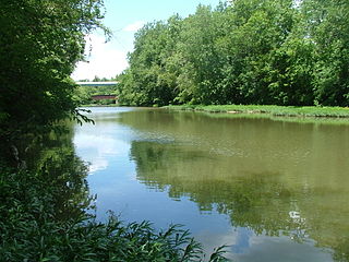
The Rice River is a 57.1-mile-long (91.9 km) tributary of the Mississippi River in northern Minnesota, United States. It rises in southeastern Aitkin County at the outlet of Porcupine Lake and flows generally north into Rice Lake National Wildlife Refuge, where it turns west and flows to the Mississippi 5 miles (8 km) northeast of Aitkin.

The Turtle River is a 17.6-mile-long (28.3 km) tidal river in the vicinity of Brunswick in Glynn County, Georgia. It is the main tributary of the Brunswick River.
The Tamarack River is an 8.8-mile-long (14.2 km) tributary of the Middle Branch Ontonagon River in Iron and Gogebic counties on the Upper Peninsula of Michigan in the United States. The stream source is the outflow from Tamarack Lake. Via the Middle Branch of the Ontonagon River, its water flows north to the Ontonagon River and ultimately to Lake Superior.

Gooseberry River is a 23-mile stream in Lake County, Minnesota, USA, draining into Lake Superior. It is known for its waterfalls, near its mouth in Gooseberry Falls State Park. The Gooseberry, like many of its neighboring streams, has an irregular discharge highly dependent on runoff from rain and snow melt. The region around the river was heavily forested and much logging took place during the early 20th century. The forest has since regrown and the falls and mouth of the river are now a thriving tourist destination.
Lindley Creek is a stream in Dallas, Hickory and Polk counties the U.S. state of Missouri. It is a tributary of the Pomme de Terre River.
Raccoon Creek is a stream in Daviess and Grundy counties in the U.S. state of Missouri. It is a tributary of Sugar Creek. The confluence is 1.5 miles southeast of the community of Brimson and 1.5 mile west of Sugar Creeks confluence with the Thompson River.
Bull Creek is a stream in Christian and Taney counties in the Ozarks of southern Missouri.

Turkey Creek is a stream in the Ozarks of southern Missouri and northern Arkansas. It is a tributary of Lake Taneycomo. The stream source is two-thirds of a mile south of the Missouri - Arkansas border in Boone County north of the village of Crest. The Missouri Pacific Railroad line follows the stream course after exiting the Crest railroad tunnel under Arkansas State Route 14 at Crest. North of the state line in Taney County the stream flows north through west Hollister to its confluence with Lake Taneycomo south of Branson. The stream covers a linear distance of 86 mi (138 km) between the border and its confluence.

Spring Creek is a stream in Douglas and Howell counties in the Ozarks of southern Missouri.
References
- ↑ Bay Lake, MN, 7.5 Minute Topographic Quadrangle, USGS, 1973
- ↑ Aitkin, MN, 7.5 Minute Topographic Quadrangle, USGS, 1973
- ↑ U.S. Geological Survey Geographic Names Information System: Ripple River
- 1 2 Minnesota Atlas & Gazetteer, Delorme, 9th ed., 2016, p. 55 ISBN 0899333338
- ↑ U.S. Geological Survey. National Hydrography Dataset high-resolution flowline data. The National Map, accessed December 26, 2012