Noto is a city and comune in the Province of Syracuse, Sicily, Italy. It is 32 kilometres (20 mi) southwest of the city of Syracuse at the foot of the Iblean Mountains. It lends its name to the surrounding area Val di Noto. In 2002 Noto and its church were declared a UNESCO World Heritage Site.

The province of Syracuse was a province in the autonomous island region of Sicily, Italy. Its capital was the city of Syracuse, a town established by Greek colonists arriving from Corinth in the 8th century BC. It had an area of 2,109 square kilometres (814 sq mi) and a total population of 403,985 (2016). Syracuse had 8% of the Sicilian population and 8.2% of Sicily's area.
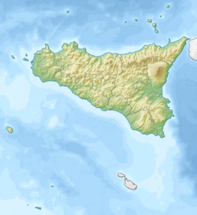
Castellammare del Golfo is a town and municipality in the Trapani Province of Sicily. The name can be translated as "Sea Fortress on the Gulf", stemming from the medieval fortress in the harbor. The nearby body of water conversely takes its name from the town, and is known as Gulf of Castellammare.

Salina is one of the Aeolian Islands north of Sicily, Southern Italy. It is the second largest island in the archipelago.

Riserva naturale orientata Saline di Trapani e Paceco is an Italian nature reserve in the Province of Trapani between the municipalities of Trapani and Paceco on the west coast of Sicily. It was founded in 1995 and in the framework of the Ramsar Convention entrusted to WWF Italy. Its area of 987 hectares consists of two zones. Besides Mediterranean flora and fauna, there is a saline work museum in an old salt mill.

Vittoria is a town and comune in the province of Ragusa, Sicily, southern Italy. With its 64,212 inhabitants, Vittoria is the second most populated municipality of the province after Ragusa.
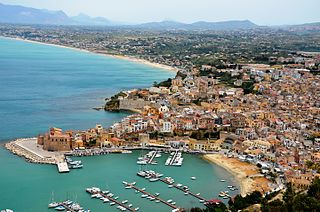
San Vito Lo Capo is a town and comune in North-Western Sicily, Italy, administratively part of the province of Trapani. The small town is located in a valley between mountains, and is home to a public beach that is destination of local vacationers.
Scopello is a coastal village, in the municipality of Castellammare del Golfo in the province of Trapani in Italy.

Calendula maritima, known as the sea marigold and trailing calendula, is a very rare species from the family of Asteraceae. Some scientists regarded it as Calendula suffruticosa subspecies maritima.

Kullaberg is a peninsula and nature reserve protruding into the Kattegat in Höganäs Municipality near the town of Mölle in southwest Sweden. The site in the province of Skåne is an area of considerable biodiversity supporting a number of rare species and has been designated as an Important Bird Area (IBA) in Sweden as well as a Special Protection Area (SPA). The terrain is dominated by steep cliffs rising from the sea and rocky outcrops on the ridge above, the highest elevation being Håkull at 188 metres. Ridgetop vegetation includes a mixed hardwood broadleaf forest consisting of birch, beech, oak and pine trees with an understory of hawthorn, juniper, wild honeysuckle and blackthorn. Among the notable rare plants are spring vetchling, Lathyrus sphaericus.

The Cassibile is a 30 km long river located in south-eastern Sicily. The river rises from the Serra Porcari, near Palazzolo Acreide, in the Hyblaean Mountains which form the main part of the mountainous Sicilian southeast. It flows into the Ionian Sea between Capo Negro and Punta del Cane, 23 km south of Syracuse. The river has created a series of canyons and near Avola Antica several waterfalls and small lakes can be accessed by the ancient Scala Cruci staircase.

Mondello is a small borough of the city of Palermo in the autonomous region of Sicily in Southern Italy.
The Valle Cavanata Nature Reserve is a 327-hectare (810-acre) protected area situated in the easternmost part of the Grado Lagoon in Grado, Italy.
Zingaro is an Italian derogatory word for a Romani man.

The Nature Reserve Bosco di Alcamo is a natural protected area of Regione Siciliana established in 1984, and located on the top of monte Bonifato, which dominates the town of Alcamo.

The gulf of Castellammare is a large and deep natural inlet going from Capo Rama and Capo San Vito near San Vito Lo Capo, in the province of Trapani. It is located on the western coast of Sicily and it faces the Tyrrhenian Sea.

San Vito Lo Capo Lighthouse is an active lighthouse located in the municipality of San Vito Lo Capo on the western coast of Sicily at the end of the promontory, with the same name, between the Gulf of Macari and that of Castellammare.

The Riserva Naturale di Monte Salviano or Riserva naturale guidata Monte Salviano is a nature reserve in Abruzzo, Italy, established in 1999. It lies in the territory of the comune (municipality) of Avezzano, in the Province of L'Aquila. The reserve is named after Monte Salviano, a massif that extends northwest to southwest dividing the Fucine basin from the Palentine Plains, in the Marsica sub-region.

Mount Porrara is a mountain in the Abruzzi Apennines, located between the lower province of L'Aquila and the province of Chieti, a natural geomorphological continuation south of the Maiella, included in the Maiella National Park.