Saltstraumen is a small strait with one of the strongest tidal currents in the world. It is located in the municipality of Bodø in Nordland county, Norway. It is located about 10 kilometres (6.2 mi) southeast of the town of Bodø. The narrow channel connects the outer Saltfjorden to the large Skjerstad Fjord between the islands of Straumøya and Knaplundsøya. The Saltstraumen Bridge on Norwegian County Road 17 crosses Saltstraumen.

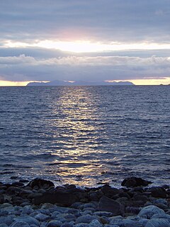
Åse is a village in Andøy Municipality in Nordland county, Norway. The village is located along the Norwegian County Road 82 on the southeastern coast of the island of Andøya, along the Andfjorden. The village of Å lies about 5 kilometres (3.1 mi) to the north, and the villages of Bjørnskinn and Risøyhamn lie about 8 kilometres (5.0 mi) to the southwest.

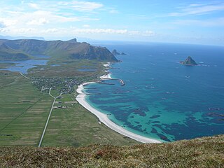
Andenes (help·info) is the administrative centre of Andøy Municipality which is located in the Vesterålen district of Nordland county, Norway. The village of Andenes is the northernmost settlement of the island of Andøya. To the east is the island of Senja, and to the west the endless horizon of the North Atlantic Ocean. Andenes Lighthouse sits along the harbor and can be seen for long distances. Andøya Airport, Andenes is located just south of the village, off of Norwegian County Road 82.

Vesterålen is a district and archipelago in Nordland county, Norway. It is located just north of the Lofoten district and archipelago and west of the town of Harstad. It is the northernmost part of Nordland county, including the municipalities of Andøy, Bø, Hadsel, Sortland, and Øksnes.

Malm (help·info) is the administrative centre of the municipality of Verran in Trøndelag county, Norway. The village of Malm is located along the Breistadsundet strait which flows into the Trondheimsfjorden. The village of Bartnes lies across the strait from Malm. The village lies about a 32 kilometres (20 mi) drive northwest of the town of Steinkjer, about 12 kilometres (7.5 mi) northwest of the village of Follafoss, and about 20 kilometres (12 mi) south of the village of Namdalseid. The Norwegian County Road 720 runs through the village.

Skarstein or Skardstein is a village in Andøy Municipality in Nordland county, Norway. The village is located along Norwegian County Road 82 on the northeastern part of the island of Andøya, along the Andfjorden. The village of Andenes lies about 10 kilometres (6.2 mi) to the north, and the village of Fiskenes lies about 2 kilometres (1.2 mi) to the northeast.

The Andøy Bridge is a cantilever road bridge that crosses the Risøysundet strait between the islands of Andøya and Hinnøya in Andøy Municipality in Nordland county, Norway. The northern end of the bridge is located in the village of Risøyhamn. The bridge is 750 metres (2,460 ft) long, the main span is 110 metres (360 ft), and the maximum clearance to the sea is 30 metres (98 ft). The bridge has 21 spans.
Bleiksvatnet is a lake in Andøy Municipality in Nordland county, Norway. The 1.74-square-kilometre (0.67 sq mi) lake is located just south of the village of Bleik on the island of Andøya. The lake sits at an elevation of 28 metres (92 ft) above sea level. The Bleikmorenen nature reserve is located on the northern shore of the lake.
Skogvollvatnet is a lake in Andøy Municipality in Nordland county, Norway. The 2.74-square-kilometre (1.06 sq mi) lake lies on the west coast of the island of Andøya. There is a 150-to-200-metre wide isthmus of land between the lake and the ocean on the west side of the lake. The tiny village of Skogvoll lies on the isthmus between the lake and the ocean.

Norwegian County Road 755 is a county road in Trøndelag county, Norway. The 91.2-kilometre (56.7 mi) road runs from the village of Røra in the municipality of Inderøy to the village of Vanvikan in Indre Fosen municipality. It was known as Norwegian National Road 755 before 2010 when control of the road was transferred from the national government to the county.
Andenes–Gryllefjord Ferry is an automotive ferry service connecting the islands of Andøya and Senja in Norway. Operated by Troms fylkestrafikk, the crossing between the villages of Andenes in Andøy Municipality and Gryllefjord in Torsken Municipality takes 1 hour and 40 minutes. The service is only operated from late May until late August, and it has three crossings per day.

County Road 82 is a road in Nordland county, Norway. It runs between the village of Fiskebøl and the town of Andenes. The road runs through the municipalities of Hadsel, Sortland, and Andøy. At Fiskebøl, the road intersects with the European route E10 highway before crossing the Hadselfjorden on the Fiskebøl–Melbu Ferry. Bridges on the road include Andøy Bridge, Sortland Bridge, Hadsel Bridge, and Børøy Bridge. Two sections are designated as part of two National Tourist Routes in Norway: the section from the intersection with E10 to Fiskebøl is part of Lofoten National Tourist Route, and the section through Andenes is part of Andenes National Tourist Route. During summer, the Andenes–Gryllefjord Ferry connects to County Road 86 at Gryllefjord on the island of Senja. Before 1 January 2010, the road was called National Road 82, but due to reforms that went into effect on that day, the county took over the ownership and maintenance of the road.

Norwegian National Road 41 is a Norwegian national road that runs through Telemark, Aust-Agder, and Vest-Agder counties in Norway. The road runs between the village of Brunkeberg in Kviteseid municipality in Telemark county in the north and Timenes in Hånes in the city of Kristiansand in Vest-Agder county in the south. The 172.9-kilometre (107.4 mi) long road connects to the European route E134 highway in the north and to the European route E18 highway in the south. The road runs for 12.5 kilometres (7.8 mi) in Vest-Agder county, 89 kilometres (55 mi) in Aust-Agder county, and 71.4 kilometres (44.4 mi) in Telemark county. The southern half of the road runs along the river Tovdalselva and the lake Herefossfjorden, and it is located in a fault zone called the Kristiansand-Porsgrunn grabenen.

Forfjorden is a fjord on the west side of the island of Hinnøya in the Vesterålen archipelago in Nordland county, Norway. The fjord lies along the border between Sortland Municipality and Andøy Municipality. The Norwegian County Road 82 follows the shoreline around the whole fjord. The coast around the Forfjorden has about 70 inhabitants. The fjord is located about 30 kilometres (19 mi) northeast of the town of Sortland and about 70 kilometres (43 mi) south of Andenes. The name is derived from its surrounding pine forest, as "Furu" and "Forra" translates to pine tree. The 7-kilometre (4.3 mi) long fjord flows to the west and joins the Gavlfjorden along with the Risøysundet and Sortlandssundet straits.

Bjørnskinn is a former municipality in Nordland county, Norway. The 310-square-kilometre (120 sq mi) municipality existed from 1924 until its dissolution in 1964. The municipality was centered around the Risøysundet strait. It encompassed the southern part of the island of Andøya and the northern part of the island of Hinnøya in the southern part of what is now Andøy Municipality. The administrative centre was the small village of Bjørnskinn where Bjørnskinn Church is located. The largest village in Bjørnskinn was the village of Risøyhamn.