River Kemp

Last updated

River Kemp
River Kemp flowing downstream - geograph.org.uk - 654982.jpg
The Kemp near to the confluence with the Clun
Location
Country England
Counties Shropshire
Physical characteristics
Mouth  
  location
River Clun, Shropshire
  coordinates
52°25′41″N2°54′43″W / 52.428°N 2.912°W / 52.428; -2.912 Coordinates: 52°25′41″N2°54′43″W / 52.428°N 2.912°W / 52.428; -2.912
Length17.3 km (10.7 mi) [1]
Basin size51 km2 (20 sq mi) [1]
Shropshire UK relief location map.jpg
Cyan pog.svg
source
Blue pog.svg
mouth
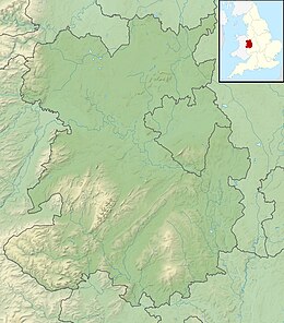
Map of Shropshire - showing the source and mouth of the River Kemp

The River Kemp is a tributary of the River Clun which flows through Shropshire, England. [1]

Contents

Course

The river is formed from two small unnamed streams that drain the area around Bishops Castle, the stream on the western side of the town rises near Bishops Moat and flows south-easterly in a well defined valley. The stream to the east rises on Lydham Heath near Lea and flows in a south-westerly direction to converge with the western stream to the east of Colebatch. The River Kemp begins at the confluence of these two streams. [1]

From this point the river then flows south, to reach the hamlet of Brockton, where it turns in a south-easterly direction to pass through the grounds on Walcot Hall, near Lydbury North. Here the river feeds the large lake known as Walcot Pool, which was allegedly constructed by French prisoners of war from the Napoleonic War. [1] [2]

To the south of Walcot Park, it is crossed by the Shropshire Way and then passes through the village of Kempton, where there is a ford and footbridge. The river continues due south, until it reaches the Clun valley near Clunbury. It joins the larger river to the east of the village at Oaker near Aston on Clun. [1]

The total length of the Kemp is 10.7 miles (17.3 km). The drainage basin for the river, which lies between that of the River Unk to the west, and that of the River Onny to the north, has a catchment area of 51 square kilometres (20 sq mi). [1]

Ecology

The River Kemp was classed as having moderate ecological quality under the Water Framework Directive in 2009, but this regressed to poor in 2016. Chemical quality remained good throughout the monitoring period. The five part framework scale ranges from high, good, and moderate, through to poor and finally bad. [1]

See also

Related Research Articles

River Meden River in Nottinghamshire, England

The River Meden is a river in Nottinghamshire, England. Its source lies just north of Huthwaite, near the Derbyshire border, and from there it flows north east through Pleasley and Warsop before merging temporarily with the River Maun near Bothamsall. The rivers divide after a short distance and go on separately to a point near Markham Moor where they once more combine to form the River Idle.

River Clun, Shropshire River in Shropshire, England

The River Clun runs mostly through Shropshire, England and joins the River Teme at Leintwardine, Herefordshire. The Clun Valley is part of the Shropshire Hills AONB.

River Meon River in Hampshire, England

The River Meon is a chalk stream in Hampshire in the south of England. It rises at East Meon then flows 34 km (21 mi) in a generally southerly direction to empty into the Solent at Hill Head near Stubbington. Above Wickham, the river runs through the South Downs National Park.

River Itchen, Warwickshire River in east Warwickshire, England

The River Itchen flows through east Warwickshire in England. It is a small river, about 18 miles (29 km) long, and its general course is from south to north.

River Coln River in Gloucestershire, England

The River Coln is a river in Gloucestershire, England. It rises to the north of Brockhampton, a village to the east of Cheltenham, and flows in a south/south-easterly direction through the Cotswold Hills via Andoversford, Withington, Fossebridge, Bibury, Coln St Aldwyns, Quenington and Fairford. It joins the River Thames to the south-west of Lechlade, where it shares a confluence with the Thames and Severn Canal, by The Round House Footbridge.

Foudry Brook River in Hampshire and Berkshire, England

Foudry Brook is a small stream in southern England. It rises from a number of springs near the Hampshire village of Baughurst, and flows to the east and then the north, to join the River Kennet to the south of Reading. The upper section is called Silchester Brook, and beyond that, Bishop's Wood Stream. The underlying geology is chalk, covered by a layer of clay, and so it has the characteristics of a clay stream, experiencing rapid increases in level after heavy rain due to run-off from the surrounding land. It passes a number of listed buildings and scheduled monuments, including the site of the Roman town of Calleva Atrebatum or Silchester.

River Perry River in Shropshire, England

The River Perry is a river in Shropshire, England. It rises near Oswestry and flows south to meet the River Severn above Shrewsbury. Along its 24 miles (39 km) length, its level drops by some 320 feet (95 m). The channel has been heavily engineered, both to enable water mills to be powered by it, and to improve the drainage of the surrounding land. There were at least seven corn mills in the 1880s, and the last one remained operational until 1966. The middle section of the river crosses Baggy Moor, where major improvements were made in 1777 to drain the moor. The scheme was one of the largest to enclose and improve land in North Shropshire, and the quality of the reclaimed land justified the high cost. A section of the river bed was lowered in the 1980s, to continue the process.

River Wylye River in Wiltshire, England

The River Wylye is a southern England chalk stream, with clear water flowing over gravel. It is popular with anglers for fly fishing. A half-mile stretch of the river and three lakes in Warminster are a local nature reserve.

River Anton River in Hampshire, England

The River Anton is a chalk stream in Hampshire in south east England. It rises in Andover and flows southwards for approximately 8 miles (13 km) to meet the River Test near Chilbolton. The principal tributary of the Anton, the Pillhill Brook, joins the river at Upper Clatford.

Meers Brook

The Meers Brook is a stream in Sheffield, England and one of the main tributaries of the River Sheaf. The Meers Brook originates in Gleadless and flows downhill through Gleadless Valley and Meersbrook then, culverted, continues underneath Heeley to pour into the River Sheaf near Saxon Road and Clyde Road in Lowfield.

River Unk, Shropshire River in Shropshire, England

The River Unk is a small river in Shropshire, England that runs for 9.7 miles (15.6 km) before flowing into the River Clun.

River Roach River in Essex, England

The River Roach is a river that flows entirely through the English county of Essex. It is one of four main streams that originate in the Rayleigh Hills to the west, and flow east. They then flow towards the centre of the Rochford Basin, a circular feature which may have been caused by an asteroid impact in the Late Oligocene or Early Miocene periods. To the east of Rochford, the river becomes tidal, and is governed by the Crouch Harbour Authority. It joins the River Crouch between Wallasea Island and Foulness Island. To the west of Rochford, there is some doubt as to which of the four streams is officially the Roach.

Lydbury North Human settlement in England

Lydbury North is a village and a geographically large civil parish in south Shropshire, England. The population of the parish at the 2011 census was 695. The parish is locally called Lydbury, and there is no settlement called Lydbury South.

Quinny Brook Stream in Shropshire, England

Quinny Brook is a tributary stream of the River Onny which flows through the Shropshire Hills Area of Outstanding Natural Beauty in England.

Barlings Eau River in Lincolnshire, England

Barlings Eau is a small river near Barlings, Lincolnshire, England. It is a tributary of the River Witham, joining it near Short Ferry. It acts as the central spine for a number of other small rivers, which drain the low-lying land to either side. Most of its course is within the area managed by the Witham Third District IDB, an Internal Drainage Board responsible for land drainage. One of their pumping stations is on the banks of the river.

Ford Green Brook Stream in Staffordshire, England

Ford Green Brook flows through Staffordshire and the outlying areas of Stoke-on-Trent, England. It is the first named tributary stream of the River Trent, and is 6.2 miles (10 km) long.

River Bourne, Warwickshire River in Warwickshire, England

The River Bourne flows for 10.9 miles (17.6 km) through North Warwickshire, England, and is a tributary of the River Tame. In the 19th century, the river with its undeveloped catchment close to Birmingham, was selected to provide a source of clean drinking water for the city.

River Box River in Suffolk, England

The River Box is a small river, 14 miles (23 km) in length, that flows through Suffolk, England. It is a tributary of the River Stour.

Finham Brook River in Warwickshire, England

The Finham Brook is a lower tributary of the River Sowe, it flows through Kenilworth and Warwickshire, England, to join the Sowe near Finham. Its principal tributaries include the Canley Brook, which drains the Tile Hill and Canley areas of Coventry, and the Inchford Brook which rises near Beausale, and then flows in an arc through the parish of Beausale, Haseley, Honiley and Wroxall. The length of the Finham and Inchford brooks is 15 miles (24 km), which have a total catchment area of 71 square kilometres (27 sq mi).

Morcott Brook Stream in Rutland, England

The Morcott Brook, also known locally as "The Foss", is a small watercourse in Rutland in the East Midlands of England. It is a tributary of the River Chater and part of the River Welland catchment.

References

  1. 1 2 3 4 5 6 7 8 "Kemp - source to conf R Clun". Catchment Data Explorer. Environment Agency. Retrieved 22 November 2017.
  2. "The Gardens". The History of Walcot Hall. Archived from the original on 16 May 2014. Retrieved 20 July 2014.

Commons-logo.svg Media related to River Kemp at Wikimedia Commons