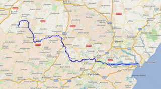
The River Stour is a major river in East Anglia, England. It is 47 miles (76 km) long and forms most of the county boundary between Suffolk to the north, and Essex to the south. It rises in eastern Cambridgeshire, passes to the east of Haverhill, through Cavendish, Sudbury, Bures, Nayland, Stratford St Mary and Dedham. It becomes tidal just before Manningtree in Essex and joins the North Sea at Harwich.

The River Gipping is the source river for the River Orwell in the county of Suffolk in East Anglia, England, which is named from the village of Gipping, and which gave its name to the former Gipping Rural District. It rises near Mendlesham Green and flows in a south-westerly direction to reach Stowmarket. From there it flows towards the south or south east, passing through Needham Market then Baylham. The river continues to flow south between Great Blakenham and Claydon, and through Bramford and Sproughton until it flows into Ipswich, where it becomes the Orwell at Stoke Bridge. The river has supplied power to a number of watermills, several of which are still standing. None are operational, although the mill at Baylham retains most of its machinery, and is the only complete mill on the river.

The Kennet and Avon Canal is a waterway in southern England with an overall length of 87 miles (140 km), made up of two lengths of navigable river linked by a canal. The name is used to refer to the entire length of the navigation rather than solely to the central canal section. From Bristol to Bath the waterway follows the natural course of the River Avon before the canal links it to the River Kennet at Newbury, and from there to Reading on the River Thames. In all, the waterway incorporates 105 locks.

The Thames and Severn Canal is a canal in Gloucestershire in the south-west of England, which was completed in 1789. It was conceived as part of a cargo route from Bristol and the Midlands to London, linking England's two largest rivers for better trade. The route climbs the steep Cotswold escarpment through the Golden Valley, tunnels underneath the summit of the Cotswold Edge, and emerges near the source of the Thames.

The canal network of the United Kingdom played a vital role in the Industrial Revolution. The UK was the first country to develop a nationwide canal network which, at its peak, expanded to nearly 4,000 miles in length. The canals allowed raw materials to be transported to a place of manufacture, and finished goods to be transported to consumers, more quickly and cheaply than by a land based route. The canal network was extensive and included feats of civil engineering such as the Anderton Boat Lift, the Manchester Ship Canal, the Worsley Navigable Levels and the Pontcysyllte Aqueduct.

The River Weaver is a river, navigable in its lower reaches, running in a curving route anti-clockwise across west Cheshire, northern England. Improvements to the river to make it navigable were authorised in 1720 and the work, which included eleven locks, was completed in 1732. An unusual clause in the enabling Act of Parliament stipulated that profits should be given to the County of Cheshire for the improvement of roads and bridges, but the navigation was not initially profitable, and it was 1775 before the first payments were made. Trade continued to rise, and by 1845, over £500,000 had been given to the county.
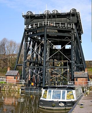
The Anderton Boat Lift is a two-caisson lift lock near the village of Anderton, Cheshire, in North West England. It provides a 50-foot (15.2 m) vertical link between two navigable waterways: the River Weaver and the Trent and Mersey Canal. The structure is designated as a scheduled monument, and is included in the National Heritage List for England; it is also known as one of the Seven Wonders of the Waterways.

The Grantham Canal ran 33 miles (53 km) from Grantham through 18 locks to West Bridgford, where it joined the River Trent. It was built primarily for the transportation of coal to Grantham. It opened in 1797 and its profitability steadily increased until 1841. It was then sold to a railway company, declined, and was finally closed in 1936. It was used as a water supply for agriculture, and so most of it remained in water after closure, although bridges were lowered. Since the 1970s, the Grantham Canal Society have been working to restore parts of it. Two stretches are now navigable to small vessels. A new route will be required where the canal joins the Trent, as road building has severed the original one.

The Wey and Arun Canal is a partially open, 23-mile-long (37 km) canal in the southeast of England. It runs southwards from the River Wey at Gunsmouth in Shalford, Surrey to the River Arun at Pallingham, in West Sussex. The canal comprises parts of two separate undertakings – the northern part of the Arun Navigation, opened in 1787 between Pallingham and Newbridge Wharf, and the Wey and Arun Junction Canal, opened in 1816, which connected the Arun at Newbridge to the Godalming Navigation near Shalford, south of Guildford. The Arun Navigation was built with three locks and one turf-sided flood lock. The Junction Canal was built with 23 locks

The canals of the United Kingdom are a major part of the network of inland waterways in the United Kingdom. They have a varied history, from use for irrigation and transport, through becoming the focus of the Industrial Revolution, to today's role of recreational boating. Despite a period of abandonment, today the canal system in the United Kingdom is again increasing in use, with abandoned and derelict canals being reopened, and the construction of some new routes. Canals in England and Wales are maintained by navigation authorities. The biggest navigation authorities are the Canal & River Trust and the Environment Agency, but other canals are managed by companies, local authorities or charitable trusts.

Caldon Canal is a branch of the Trent and Mersey Canal which opened in 1779. It runs 18 miles (29 km) from Etruria, Stoke-on-Trent, to Froghall, Staffordshire. The canal has 17 locks and the 76-yard (69 m) Froghall Tunnel.

The Montgomery Canal, known colloquially as "The Monty", is a partially restored canal in eastern Powys and northwest Shropshire. The canal runs 33 miles (53 km) from the Llangollen Canal at Frankton Junction to Newtown via Llanymynech and Welshpool and crosses the England–Wales border.

The Sleaford Navigation was a 12.5-mile (20.1 km) canalisation of the River Slea in Lincolnshire, England, which opened in 1794. It ran from a junction with the River Witham, near Chapel Hill to the town of Sleaford through seven locks, most of which were adjacent to mills. Lack of finance meant that it stopped short of its intended terminus, but it gradually grew to be successful financially. The coming of the railways in 1857 led to a rapid decline, and it was officially abandoned by an act of Parliament in 1878, but remained open for a further three years. The lower part of it remained navigable until the 1940s, when it was blocked by a sluice.

The Derby and Sandiacre Canal Trust is a waterway society, a charitable trust no. 1042227, registered 21 November 1994, and a registered company No. 2956417, operating in Derbyshire and Nottinghamshire, England, UK. Through its membership, the associated canal society supports the operation of the trust.

The Foxton Inclined Plane Trust is a waterway society and a registered charity on the Grand Union Canal in Foxton, Leicestershire, England, UK. It was founded in 1980 to promote the restoration of the Victorian boat lift or inclined plane, a unique and famous piece of canal history.

The Bradley Branch or Bradley Locks Branch was a short canal of the Birmingham Canal Navigations in the West Midlands, England. Completed in 1849, it included nine locks, and had a number of basins which enabled it to service local collieries and industrial sites. The locks were unusual, as they had a single gate at both ends, rather than double gates at the bottom end. The route closed in the 1950s, and the top seven locks were covered over and landscaped.

The Canal & River Trust (CRT), branded as Glandŵr Cymru in Wales, holds the guardianship of 2,000 miles of canals and rivers, together with reservoirs and a wide range of heritage buildings and structures, in England and Wales. Launched on 12 July 2012, the Trust took over the responsibilities of the state-owned British Waterways in England and Wales.
Northwich is a civil parish and a town in Cheshire West and Chester, England. It contains 35 buildings that are recorded in the National Heritage List for England as designated listed buildings. Two of these are listed at Grade I, the highest grade, and the rest at the lowest grade, Grade II; none are listed at the middle grade, Grade II*. The River Dane joins the River Weaver and the Weaver Navigation within the parish. Also passing through the parish are the A533 road, the Trent and Mersey Canal, and a railway built by the Cheshire Lines Committee. Many of the listed buildings are associated with these features.
Barnton is a village and a civil parish in Cheshire West and Chester, England. It contains 11 buildings that are recorded in the National Heritage List for England as designated listed buildings, all of which are at Grade II. This grade is the lowest of the three gradings given to listed buildings and is applied to "buildings of national importance and special interest". Running through the parish are the Trent and Mersey Canal, which passes through two tunnels, and the River Weaver together with the Weaver Navigation. The majority of the listed buildings in the parish are associated with these transport links. Associated with the canal are four tunnel entrances, an airshaft, two mileposts, and a terrace of cottages. The Weaver Navigation contains Saltersford Locks, and its toll house. The other listed building is the village church, Christ Church.

Dutton Locks is a historic lock on the River Weaver in Cheshire, England. The locks are Grade II listed with Historic England. The locks are still in use and form a destination for walkers and cyclists. Dutton Locks is also the name of a hamlet of approximately six residences adjacent to the locks.
