Rivière-Ojima | |
---|---|
Unorganized territory | |
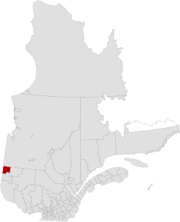
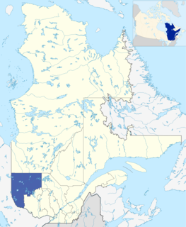
![]() Location within Abitibi-Ouest RCM. | |
Coordinates: 48°50′N78°42′W / 48.833°N 78.700°W Coordinates: 48°50′N78°42′W / 48.833°N 78.700°W [1] | |
Country | ![]() |
Province | ![]() |
Region | Abitibi-Témiscamingue |
RCM | Abitibi-Ouest |
Constituted | January 1, 1986 |
Government [2] | |
• Federal riding | Abitibi—Témiscamingue |
• Prov. riding | Abitibi-Ouest |
Area [2] [3] | |
• Total | 356.20 km2 (137.53 sq mi) |
• Land | 356.04 km2 (137.47 sq mi) |
Population (2011) [3] | |
• Total | 104 |
• Density | 0.3/km2 (0.8/sq mi) |
• Pop 2006-2011 | ![]() |
• Dwellings | 51 |
Time zone | EST (UTC−5) |
• Summer (DST) | EDT (UTC−4) |
Highways | No major routes |
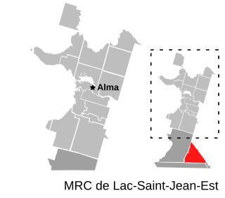
Rivière-Ojima is an unorganized territory in the Abitibi-Témiscamingue region of Quebec, Canada. It consists of two non-contiguous areas in the Abitibi-Ouest Regional County Municipality, separated by the municipality of Authier-Nord. The communities of Languedoc ( 48°48′26″N78°41′48″W / 48.80722°N 78.69667°W ) and Saint-Eugène-de-Chazel ( 48°57′06″N78°58′38″W / 48.95167°N 78.97722°W ) are located within its boundaries.
Abitibi-Témiscamingue is an administrative region located in western Québec, Canada, along the border with Ontario. It became part of the province in 1898. It has a land area of 57,674.26 km2. The region is divided into five regional county municipalities and 79 municipalities. Its economy continues to be dominated by resource extraction industries. These include logging, mining all along the rich geologic Cadillac Fault between Val-d'Or and Rouyn-Noranda, as well as agriculture.
Quebec is one of the thirteen provinces and territories of Canada. It is bordered to the west by the province of Ontario and the bodies of water James Bay and Hudson Bay; to the north by Hudson Strait and Ungava Bay; to the east by the Gulf of Saint Lawrence and the province of Newfoundland and Labrador; and to the south by the province of New Brunswick and the U.S. states of Maine, New Hampshire, Vermont, and New York. It also shares maritime borders with Nunavut, Prince Edward Island, and Nova Scotia. Quebec is Canada's largest province by area and its second-largest administrative division; only the territory of Nunavut is larger. It is historically and politically considered to be part of Central Canada.
Geographic contiguity is the characteristic in geography of political or geographical land divisions, as a group, not being interrupted by other land or water. Such divisions are referred to as being contiguous. In the United States, for example, the "48 contiguous states" excludes Hawaii and Alaska, which do not share borders with other U.S. states.
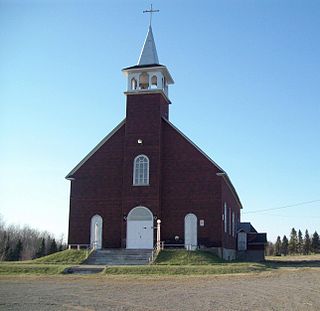
Founded in 1949, Languedoc is the youngest rural population centre of the Abitibi and named after a region in southern France. The Parish of Saint-Etienne-de-Languedoc was formed in 1952. [4]
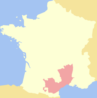
Languedoc is a former province of France. Its territory is now contained in the modern-day region of Occitanie in the south of France. Its capital city was Toulouse. It had an area of approximately 27,376 square kilometers.
Canada census – Rivière-Ojima, Quebec community profile | |||
---|---|---|---|
2011 | 2006 | ||
Population: | 104 (-17.5% from 2006) | 126 (+14.5% from 2001) | |
Land area: | 356.04 km2 (137.47 sq mi) | 356.03 km2 (137.46 sq mi) | |
Population density: | 0.3/km2 (0.78/sq mi) | 0.4/km2 (1.0/sq mi) | |
Median age: | 50.6 (M: 54.5, F: 48.5) | 45.0 (M: 48.0, F: 38.5) | |
Total private dwellings: | 51 | 53 | |
Median household income: | $.N/A | $.N/A | |
Notes: Income data for this area has been suppressed for data quality or confidentiality reasons. – References: 2011 [3] 2006 [5] earlier [6] |
Historical Census Data - Rivière-Ojima, Quebec [7] | ||||||||||||||||||||||||||
---|---|---|---|---|---|---|---|---|---|---|---|---|---|---|---|---|---|---|---|---|---|---|---|---|---|---|
|
|
|
Canada Census Mother Tongue - Rivière-Ojima, Quebec [7] | ||||||||||||||||||
---|---|---|---|---|---|---|---|---|---|---|---|---|---|---|---|---|---|---|
Census | Total | French | English | French & English | Other | |||||||||||||
Year | Responses | Count | Trend | Pop % | Count | Trend | Pop % | Count | Trend | Pop % | Count | Trend | Pop % | |||||
2011 | 100 | 100 | ![]() | 100.00% | 0 | ![]() | 0.00% | 0 | ![]() | 0.00% | 0 | ![]() | 0.00% | |||||
2006 | 120 | 120 | ![]() | 100.00% | 0 | ![]() | 0.00% | 0 | ![]() | 0.00% | 0 | ![]() | 0.00% | |||||
2001 | 115 | 115 | ![]() | 100.00% | 0 | ![]() | 0.00% | 0 | ![]() | 0.00% | 0 | ![]() | 0.00% | |||||
1996 | 120 | 120 | n/a | 100.00% | 0 | n/a | 0.00% | 0 | n/a | 0.00% | 0 | n/a | 0.00% |
The Ojima River is a tributary of Turgeon Lake, flowing in the township of Chazel, into the unorganized territory of Rivière-Ojima, Quebec and into the municipality of Val-Saint-Gilles, Quebec, in the regional county municipality (RCM) of Abitibi-Ouest, in the administrative region of Abitibi-Temiscamingue, in Quebec, in Canada.
Rouyn-Noranda is a city on Osisko Lake in the Abitibi-Témiscamingue region of Quebec, Canada.
Abitibi Regional County Municipality is a regional county municipality in the Abitibi-Témiscamingue region of Quebec. The seat is Amos.
Abitibi-Ouest Regional County Municipality is a regional county municipality located in the Abitibi-Témiscamingue region of Quebec. Its seat is La Sarre.
Témiscamingue is a regional county municipality in the Abitibi-Témiscamingue region of western Quebec, Canada. The county seat is Ville-Marie.
Senneterre is a town in the Abitibi-Témiscamingue region of northwestern Quebec, Canada. It is in the Vallée-de-l'Or Regional County Municipality. The town's territory includes a vast undeveloped area stretching from the Bell River to the Mauricie region. The town centre itself is about 60 kilometres (37 mi) northeast of Val-d'Or on the banks of the Bell River, at the intersection of the Canadian National Railway and Quebec Route 113.
Berry is a municipality in the Canadian province of Quebec, located in the Abitibi Regional County Municipality. The municipality had a population of 625 as of the Canada 2011 Census.
Clerval is a municipality in northwestern Quebec, Canada, in the Abitibi-Ouest Regional County Municipality. It covers 101.6 km² and had a population of 364 as of the Canada 2011 Census.
Lac-Chicobi is an unorganized territory in the Canadian province of Quebec, located within the Abitibi Regional County Municipality. The area consists of two non-contiguous portions on either side of the incorporated municipality of Berry.
Lac-Despinassy is an unorganized territory in the Canadian province of Quebec, located within the Abitibi Regional County Municipality. The area is east of the municipality of Saint-Dominique-du-Rosaire, north of La Morandière, Rochebaucourt and the parish municipality of Senneterre, and west of the city of Senneterre.
Les Lacs-du-Témiscamingue is a vast unorganized territory in the Abitibi-Témiscamingue region of Quebec, Canada. With a surface area of 10,410 square kilometres (4,020 sq mi), it takes up over 60% of the eastern portion of the Témiscamingue Regional County Municipality.
Laniel is an unorganized territory in the Témiscamingue Regional County Municipality, Abitibi-Témiscamingue region, Quebec, Canada. It surrounds the northern portion of Lake Kipawa.
Lac-Duparquet is an unorganized territory in the Abitibi-Témiscamingue region of Quebec, Canada. It is one of two unorganized territories in the Abitibi-Ouest Regional County Municipality but the only one without a permanent population. It is located between Duparquet Lake and the Quebec/Ontario border.
Réservoir-Dozois is an unorganized territory in the Abitibi-Témiscamingue region of Quebec, Canada. It is the largest of five unorganized territories in the La Vallée-de-l'Or Regional County Municipality and entirely part of the La Vérendrye Wildlife Reserve.
Matchi-Manitou is an unorganized territory in the Abitibi-Témiscamingue region of Quebec, Canada. It is one of five unorganized territories in La Vallée-de-l'Or Regional County Municipality.
Lac-Metei is an unorganized territory in the Abitibi-Témiscamingue region of Quebec, Canada. It is one of five unorganized territories in the La Vallée-de-l'Or Regional County Municipality.
Lac-Masketsi is an unorganized territory in the Mauricie region of province of Quebec, Canada, part of the Mékinac Regional County Municipality. Most of its area is part of the Zec Tawachiche. The discharge of Masketsi Lake at the south-east flows in the Little Lake Masketsi, which empties into the Tawachiche West River.
Lac-Achouakan is an unorganized territory in the Canadian province of Quebec, located in the regional county municipality of Lac-Saint-Jean-Est. It had a population of zero in the Canada 2006 Census, and covered a land area of 227.35 km2, entirely within the Laurentides Wildlife Reserve. The western boundary of the territory is Bark River, while Quebec Route 169 forms the eastern boundary.
Sagard is an unorganized territory and hamlet in the Capitale-Nationale region of Quebec, Canada, part of the Charlevoix-Est Regional County Municipality. The hamlet of Sagard is located on the eastern banks of the Little Saguenay River, along Route 170 between Saint-Siméon and Petit-Saguenay.
Rivière-Bonjour is an unorganized territory in the Bas-Saint-Laurent region of Quebec, Canada. A large part of the territory is part of the Matane Wildlife Reserve.
Routhierville is an unorganized territory in the Bas-Saint-Laurent region of Quebec, Canada. The territory is bisected by the Matapédia River and Quebec Route 132 that runs parallel to it. There are two hamlets in the territory: the eponymous Routhierville and Milnikek.
![]() | This Abitibi-Témiscamingue location article is a stub. You can help Wikipedia by expanding it. |