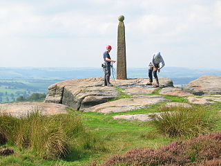
Stanage Edge, or simply Stanage is a gritstone escarpment in the Peak District, England, famous as a location for climbing. It lies a couple of miles to the north of Hathersage, and the northern part of the edge forms the border between the High Peak of Derbyshire and Sheffield in South Yorkshire. Its highest point is High Neb at 458 metres (1,503 ft) above sea level. Areas of Stanage were quarried in the past to produce grindstones, and some can still be seen on the hillside—carved, but never removed.

Robin Hood: Men in Tights is a 1993 adventure comedy film and a parody of the Robin Hood story. The film was produced and directed by Mel Brooks, co-written by Brooks, Evan Chandler, and J. David Shapiro based on a story by Chandler and Shapiro, and stars Cary Elwes, Richard Lewis, and Dave Chappelle in his film debut. It includes frequent comedic references to previous Robin Hood films, particularly Prince of Thieves, and the 1938 Errol Flynn adaptation The Adventures of Robin Hood. Brooks himself had previously created the short-lived sitcom When Things Were Rotten in the mid-1970s, which also spoofed the Robin Hood legend.

Birchen Edge is a gritstone rock face in the Peak District, England, popular with walkers and novice climbers as most of the climbing routes are in the lower grade.

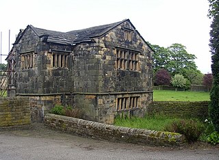
Kirklees Hall is a 16th-century Grade I listed Jacobean hall, close to the English village of Clifton in Calderdale, West Yorkshire.

Barnsdale, or Barnsdale Forest, is an area of South and West Yorkshire, England. The area falls within the modern-day districts of Doncaster and Wakefield. Barnsdale was historically part of the West Riding of Yorkshire. Barnsdale is commonly associated with Robin Hood.

Parkhouse Hill is a small but distinctive hill in the Peak District National Park of the Hartington Middle Quarter civil parish, in the English county of Derbyshire. It lies on the north side of the River Dove, close to the border with Staffordshire.

Whitwell railway station serves the village of Whitwell in Derbyshire, England. The station is on the Robin Hood Line 4¾ miles (7 km) south west of Worksop towards Nottingham.

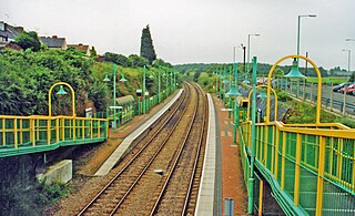
Langwith-Whaley Thorns railway station is in Derbyshire, England. The station is on the Robin Hood Line 22¼ miles (36 km) north of Nottingham towards Worksop.

Kirkby-in-Ashfield railway station serves the town of Kirkby-in-Ashfield in Nottinghamshire, England. The station is on the Robin Hood Line and is operated by East Midlands Railway between Nottingham and Worksop.
Robin Hood Rescuing Will Stutly is a traditional English-language folk song about Robin Hood.

The Tales of Robin Hood was from 1989 to 2009 an indoor visitor attraction and medieval banqueting centre based on the Nottinghamshire legend of Robin Hood. The centre was located on Maid Marian Way in Nottingham city centre, in the vicinity of Nottingham Castle, and brought an estimated £2 million in tourism revenue to the city each year.

Hidden Valleys is a name, coined in 2004, used to describe an area of interesting historical and scenic value between the city of Nottingham and the town of Mansfield in the English ceremonial county of Nottinghamshire. Promotional literature and tourist information for the Hidden Valleys were created to encourage tourism in an area that had been blighted by industrial decline. Partners in the project were: Ashfield District Council; Gedling Borough Council; the East Midlands Development Agency; Nottinghamshire County Council; and the Coalfields Regeneration Trust. It was intended by the partners that the name would help the Ashfield area compete with the Peak District and Sherwood Forest.

A swashbuckler film is characterised by swordfighting and adventurous heroic characters, known as swashbucklers. While morality is typically clear-cut, heroes and villains alike often, but not always, follow a code of honor. Some swashbuckler films have romantic elements, most frequently a damsel in distress. Both real and fictional historical events often feature prominently in the plot.
Annesley railway station was a station in Annesley, Nottinghamshire. It was opened in 1874, to serve the mining village of Annesley which had grown following the opening of Annesley colliery in 1865. It was closed in 1953 as part of the post-war cutback, and the line closed to passengers in 1964. The station did not reopen as part of the Robin Hood Line project in the 1990s.

The A6135 is a 4 digit A road in Derbyshire and South Yorkshire, England.

Robin Hood Hills or Robin Hood's Hills are a steep sided range of sandstone hills forming a natural amphitheatre surrounding the villages of Annesley and Newstead in Nottinghamshire, England. Robin Hood's Cave lies at the bottom of the hills. They rise to a height of 195 metres above sea level at Coxmoor, Kirkby-in-Ashfield. A railway tunnel passes underneath the hills on the Robin Hood Line railway between Newstead railway station and Kirkby-in-Ashfield railway station.

Loxley House is a Georgian building situated off Ben Lane in the Wadsley area of Sheffield in South Yorkshire, England. It is a Grade Two Listed building.
Langwith is a former railway station in the Langwith Maltings area of Langwith in north eastern Derbyshire, England.

Harthill Moor is a small upland area in the Derbyshire Peak District of central and northern England, lying between Matlock and Bakewell near the villages of Birchover and Elton. The moor is within the southern portion of Harthill civil parish. Its highest point is 272 metres (892 ft) above sea level. The River Bradford flows along the northern edge of the moor past Youlgreave and into the River Lathkill at Alport. Harthill Moor is a rich prehistoric landscape with several protected Scheduled Ancient Monuments.
Pinxton and Selston railway station served the villages of Pinxton, Derbyshire and Selston, Nottinghamshire. It was located on the Midland Railway's Mansfield Branch Line. It was one of three stations that served the village of Pinxton. The others were Pinxton South and Pye Hill and Somercotes.


