Shelby County is a county located in the U.S. state of Kentucky. As of the 2010 census, the population was 42,074. The county seat is Shelbyville. The county was founded in 1792 and named for Isaac Shelby, the first Governor of Kentucky.
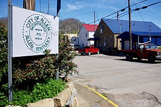
Allen is a home rule-class city in Floyd County, Kentucky, in the United States. The population was 193 at the 2010 census, up from 150 at the 2000 census.

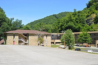
Martin is a home rule-class city in Floyd County, Kentucky, in the United States. The population was 634 as of the 2010 census.
Pippa Passes is a home rule-class city located along Caney Creek in Knott County, eastern Kentucky, United States. Its formal name was chosen to honor benefactors of Alice Lloyd College. After more than a century, its residents commonly call the community as Caney or Caney Creek. The population was 533 at the time of the year 2010 U.S. Census. The small city is located in the mountainous Appalachia region, an area of coal mining.

Blackey is a home rule-class city in Letcher County, Kentucky, in the United States. As of the 2000 census, the population was 153. It is located near the early settlement of Indian Bottom. Blackey is thought to have been named after Blackey Brown, one of its citizens.

Shelby Charter Township, officially the Charter Township of Shelby, is a charter township and census-designated place located in Macomb County in the U.S. state of Michigan. The township, an affluent northern suburb of Detroit, is located roughly 15 miles north of the city. As of the 2000 census, the township had a total population of 65,159. The 2010 Census places the population at 73,804. Shelby Charter Township is one of the fastest growing communities in Metro Detroit.

The Battle of Middle Creek was an engagement fought January 10, 1862, in Eastern Kentucky during the American Civil War.
Otter Creek Correctional Center was a minimum and medium-security prison located in Wheelwright, Kentucky. The facility is owned and operated by Corrections Corporation of America and housed both male and female inmates at different times, from Kentucky and from Hawaii. The prison opened in 1981.

Fort Shelby was a United States military installation in Prairie du Chien, Wisconsin, built in 1814. It was named for Isaac Shelby, Revolutionary War soldier and first governor of Kentucky. The fort was captured by the British during the Siege of Prairie du Chien in July 1814. The British renamed the fort Fort McKay after Major William McKay, the commander of the forces that won the battle. Fort McKay remained under British control until 1815, when the British destroyed it before leaving the area. Fort Crawford was built on the same site in 1816.

Dorton is an unincorporated community and coal town in southern Pike County, Kentucky, United States. Located along U.S. Route 23, also known as Country Music Highway, it lies at 37.27667°N, 82.57917°W at an altitude of 683 feet. It is centered at the confluence of Dorton and Shelby Creeks and the junction of U.S. 23 and KY 610, 13 miles south of Pikeville.
Drift, Kentucky is an unincorporated community and coal town in Floyd County, Kentucky, United States. As of the census of 2000, there were 569 people residing in the ZIP Code Tabulation Area (ZCTA) for Drift's ZIP code (41619).
Unity, Kentucky is a small unincorporated community and former coal mining community that formerly had a U.S. Post Office located two miles west of Catlettsburg. Kentucky Route 168 passes through the hamlet. Catletts Creek, a tributary of the Ohio River, runs through the community of Unity. Unity was served by the Catletts Creek School, later named Eidson Elementary, from 1962 to 1993, when all students were transferred to Catlettsburg Elementary. The hamlet of Unity is virtually non-existent today, as most residents of Unity refer to Catlettsburg as their home, since it is the postal zip code used.
Blackberry Creek is a stream in Pike County, Kentucky, in the United States. It is a tributary of the Tug Fork, part of the Big Sandy River and thus the Ohio River watershed.
Beefhide is an unincorporated community spanning across a county line between Letcher County and Pike County, Kentucky, United States.
Defeated Creek is a stream in Knott County, Kentucky, in the United States.
Defeated Creek is a stream in Letcher County, Kentucky, in the United States.
Defeated Creek is an unincorporated community in Letcher County, Kentucky, in the United States.
Beaver Creek is a stream in Floyd County, Kentucky, in the United States.
Betty Troublesome Creek is a stream in Knox County, Kentucky, in the United States.
Beefhide Creek is a stream in Letcher and Pike Counties of the U.S. state of Kentucky.