Related Research Articles

Adobe RoboHelp is a help authoring tool (HAT) developed and published by Adobe Inc. for Windows. RoboHelp was created by Gen Kiyooka, and Blue Sky Software released version 1.0 in January 1992.
A geocode is a code that represents a geographic entity. It is a unique identifier of the entity, to distinguish it from others in a finite set of geographic entities. In general the geocode is a human-readable and short identifier.
GeoTIFF is a public domain metadata standard which allows georeferencing information to be embedded within a TIFF file. The potential additional information includes map projection, coordinate systems, ellipsoids, datums, and everything else necessary to establish the exact spatial reference for the file. The GeoTIFF format is fully compliant with TIFF 6.0, so software incapable of reading and interpreting the specialized metadata will still be able to open a GeoTIFF format file.

A geotagged photograph is a photograph which is associated with a geographical location by geotagging. Usually this is done by assigning at least a latitude and longitude to the image, and optionally altitude, compass bearing and other fields may also be included.
Image sharing, or photo sharing, is the publishing or transfer of a user's digital photos online. Image sharing websites offer services such as uploading, hosting, managing and sharing of photos. This function is provided through both websites and applications that facilitate the upload and display of images. The term can also be loosely applied to the use of online photo galleries that are set up and managed by individual users, including photoblogs. Sharing means that other users can view but not necessarily download images, and users can select different copyright options for their images.
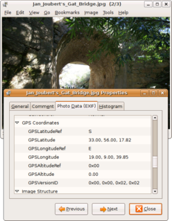
Geotagging, or GeoTagging, is the process of adding geographical identification metadata to various media such as a geotagged photograph or video, websites, SMS messages, QR Codes or RSS feeds and is a form of geospatial metadata. This data usually consists of latitude and longitude coordinates, though they can also include altitude, bearing, distance, accuracy data, and place names, and perhaps a time stamp.
Geocoding is the process of taking input text, such as an address or the name of a place, and returning a latitude/longitude location on the Earth's surface for that place. Reverse geocoding, on the other hand, converts geographic coordinates to a description of a location, usually the name of a place or an addressable location. Geocoding relies on a computer representation of address points, the street / road network, together with postal and administrative boundaries.

digiKam is a free and open-source image organizer and tag editor written in C++ using the KDE Applications.

Geolocation is the identification or estimation of the real-world geographic location of an object, such as a radar source, mobile phone, or Internet-connected computer terminal. In its simplest form, geolocation involves the generation of a set of geographic coordinates and is closely related to the use of positioning systems, but its usefulness is enhanced by the use of these coordinates to determine a meaningful location, such as a street address.

QGIS is a free and open-source cross-platform desktop geographic information system (GIS) application that supports viewing, editing, and analysis of geospatial data.
Georeferencing means that the internal coordinate system of a map or aerial photo image can be related to a ground system of geographic coordinates. The relevant coordinate transforms are typically stored within the image file, though there are many possible mechanisms for implementing georeferencing. The most visible effect of georeferencing is that display software can show ground coordinates and also measure ground distances and areas. In other words, Georeferencing means to associate something with locations in physical space. The term is commonly used in the geographic information systems field to describe the process of associating a physical map or raster image of a map with spatial locations. Georeferencing may be applied to any kind of object or structure that can be related to a geographical location, such as points of interest, roads, places, bridges, or buildings.

The Wii Shop Channel was an online shop for the Wii video game console that allowed users to download Virtual Console games, WiiWare games, and additional channels. The channel launched on November 19, 2006, and ceased operations on January 30, 2019. Available software was organized into three sections: Virtual Console, WiiWare, and Wii Channels. It is impossible to purchase content on the channel. But all previously purchased content can still be re-downloaded indefinitely as of February 1, 2019. Upon its discontinuation, most software was removed from the channel, and the shop's interface reverted to its original 2006 design.
TopoFusion GPS Mapping software designed to plan and analyze trails using topographic maps and GPS tracks.

CamStudio is an open-source screencasting program for Microsoft Windows released as free software. The software renders videos in an AVI format. It can also convert these AVIs into Flash Video format, embedded in SWF files. CamStudio is written in C++, but CamStudio 3 will be developed in C#. The program has distributed malware and harmful viruses via the installer.
FastPictureViewer is a freemium image viewer for Windows XP and later. Its aim is to facilitate quick review, rating and annotation of large quantities of digital images in the early steps of the digital workflow, with an emphasis on simplicity and speed. As an app with a freemium license, a basic version is available cost-free for personal, non-profit or educational uses, while a commercial license is required for the professional version with additional features. The basic version starts as a full version trial.
The Ricoh 500SE digital compact camera is suitable for outdoor photography and networkability. Capability includes external information such as GPS position or barcode numbers within the image headers. External vendors sell hardware and software for workflows involving GPS positioning or barcode scanning. Most NMEA compliant bluetooth GPS receivers can be used with this camera through its built in bluetooth communication capability. The body is resistant to dust and water, making it robust for many environments.
This is a list of free and open-source software for geophysical data processing and interpretation. The list is split into broad categories, depending on the intended use of the software and its scope of functions.
DBGallery is a Digital Asset Management software package and cloud service. It has a special focus on utilizing image meta-data for finding, exploring and organizing photos. It is a multi-user system for use across an organization. While typically run as on-premises software, since mid-2013 the company has offered it as a SaaS cloud-hosted solution. The on-premises software version enables controlled access to the collection via the Internet using a web server plugin.
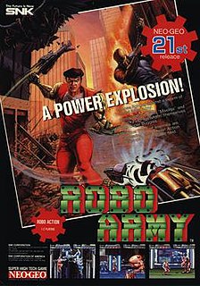
Robo Army is a beat 'em up video game developed and published by SNK that was released for Neo Geo arcades and home consoles in 1991 and the Neo Geo CD in 1995.
References
- ↑ Schuyler Erle; Rich Gibson; Jo Walsh. Mapping Hacks: Tips & Tools for Electronic Cartography. p. 34.
- ↑ "Travel by GPS review of RoboGEO". Archived from the original on 2006-12-31. Retrieved 2007-01-14.
- ↑ "Download RoboGEO" . Retrieved 2007-01-14.
- ↑ "RoboGEO Demo Limitations" . Retrieved 2007-01-14.