Geocoding

Last updated

Geocoding is the process of taking a text-based description of a location, such as an address or the name of a place, and returning geographic coordinates, frequently latitude/longitude pair, to identify a location on the Earth's surface. [1] Reverse geocoding, on the other hand, converts geographic coordinates to a description of a location, usually the name of a place or an addressable location. Geocoding relies on a computer representation of address points, the street / road network, together with postal and administrative boundaries.

Contents

The geographic coordinates representing locations often vary greatly in positional accuracy. Examples include building centroids, land parcel centroids, interpolated locations based on thoroughfare ranges, street segments centroids, postal code centroids (e.g. ZIP codes, CEDEX), and Administrative division Centroids.

History

Geocoding – a subset of Geographic Information System (GIS) spatial analysis – has been a subject of interest since the early 1960s.

1960s

In 1960, the first operational GIS – named the Canada Geographic Information System (CGIS) – was invented by Dr. Roger Tomlinson, who has since been acknowledged as the father of GIS. The CGIS was used to store and analyze data collected for the Canada Land Inventory, which mapped information about agriculture, wildlife, and forestry at a scale of 1:50,000, in order to regulate land capability for rural Canada. However, the CGIS lasted until the 1990s and was never available commercially.

On 1 July 1963, five-digit ZIP codes were introduced nationwide by the United States Post Office Department (USPOD). In 1983, nine-digit ZIP+4 codes were brought about as an extra identifier in more accurately locating addresses.

In 1964, the Harvard Laboratory for Computer Graphics and Spatial Analysis developed groundbreaking software code – e.g. GRID, and SYMAP – all of which were sources for commercial development of GIS.

In 1967, a team at the Census Bureau – including the mathematician James Corbett [4] and Donald Cooke [5] – invented Dual Independent Map Encoding (DIME) – the first modern vector mapping model – which ciphered address ranges into street network files and incorporated the "percent along" geocoding algorithm. [6] Still in use by platforms such as Google Maps and MapQuest, the "percent along" algorithm denotes where a matched address is located along a reference feature as a percentage of the reference feature's total length. DIME was intended for the use of the United States Census Bureau, and it involved accurately mapping block faces, digitizing nodes representing street intersections, and forming spatial relationships. New Haven, Connecticut was the first city on Earth with a geocodable streets network database.

1980s

In the late 1970s, two main public domain geocoding platforms were in development: GRASS GIS and MOSS. The early 1980s saw the rise of many more commercial vendors of geocoding software, namely Intergraph, ESRI, CARIS, ERDAS, and MapInfo Corporation. These platforms merged the 1960s approach of separating spatial information with the approach of organizing this spatial information into database structures.

In 1986, Mapping Display and Analysis System (MIDAS) became the first desktop geocoding software, designed for the DOS operating system. Geocoding was elevated from the research department into the business world with the acquisition of MIDAS by MapInfo. MapInfo has since been acquired by Pitney Bowes, and has pioneered in merging geocoding with business intelligence; allowing location intelligence to provide solutions for the public and private sectors.

1990s

The end of the 20th century had seen geocoding become more user-oriented, especially via open-source GIS software. Mapping applications and geospatial data had become more accessible over the Internet.

Because the mail-out/mail-back technique was so successful in the 1980 Census, the U.S. Bureau of Census was able to put together a large geospatial database, using interpolated street geocoding. [7] This database – along with the Census' nationwide coverage of households – allowed for the birth of TIGER (Topologically Integrated Geographic Encoding and Referencing).

Containing address ranges instead of individual addresses, TIGER has since been implemented in nearly all geocoding software platforms used today. By the end of the 1990 Census, TIGER "contained a latitude/longitude-coordinate for more than 30 million feature intersections and endpoints and nearly 145 million feature 'shape' points that defined the more than 42 million feature segments that outlined more than 12 million polygons." [8]

TIGER was the breakthrough for "big data" geospatial solutions.

2000s

The early 2000s saw the rise of Coding Accuracy Support System (CASS) address standardization. The CASS certification is offered to all software vendors and advertising mailers who want the United States Postal Services (USPS) to assess the quality of their address-standardizing software. The annually renewed CASS certification is based on delivery point codes, ZIP codes, and ZIP+4 codes. Adoption of a CASS certified software by software vendors allows them to receive discounts in bulk mailing and shipping costs. They can benefit from increased accuracy and efficiency in those bulk mailings, after having a certified database. In the early 2000s, geocoding platforms were also able to support multiple datasets.

In 2003, geocoding platforms were capable of merging postal codes with street data, updated monthly. This process became known as "conflation".

Beginning in 2005, geocoding platforms included parcel-centroid geocoding. Parcel-centroid geocoding allowed for a lot of precision in geocoding an address. For example, parcel-centroid allowed a geocoder to determine the centroid of a specific building or lot of land. Platforms were now also able to determine the elevation of specific parcels.

2005 also saw the introduction of the Assessor's Parcel Number (APN). A jurisdiction's tax assessor was able to assign this number to parcels of real estate. This allowed for proper identification and record-keeping. An APN is important for geocoding an area which is covered by a gas or oil lease, and indexing property tax information provided to the public.

In 2006, Reverse Geocoding and reverse APN lookup were introduced to geocoding platforms. This involved geocoding a numerical point location – with a longitude and latitude – to a textual, readable address.

2008 and 2009 saw the growth of interactive, user-oriented geocoding platforms – namely MapQuest, Google Maps, Bing Maps, and Global Positioning Systems (GPS). These platforms were made even more accessible to the public with the simultaneous growth of the mobile industry, specifically smartphones.

2010s

The 2010s saw vendors fully support geocoding and reverse geocoding globally. Cloud-based geocoding application programming interface (API) and on-premises geocoding have allowed for a greater match rate, greater precision, and greater speed. There is now a popularity in the idea of geocoding being able to influence business decisions. This is the integration between the geocoding process and business intelligence.

The future of geocoding also involves three-dimensional geocoding, indoor geocoding, and multiple language returns for the geocoding platforms.

Geocoding process

Geocoding is a task which involves multiple datasets and processes, all of which work together. A geocoder is made of two important components: a reference dataset and the geocoding algorithm. Each of these components are made up of sub-operations and sub-components. Without understanding how these geocoding processes work, it is difficult to make informed business decisions based on geocoding.

Input data

Input data are the descriptive, textual information (address or building name) which the user wants to turn into numerical, spatial data (latitude and longitude) – through the process of geocoding.

Classification of input data

Input data is classified into two categories: relative input data and absolute input data.

Relative input data

Relative input data are the textual descriptions of a location which, alone, cannot output a spatial representation of that location. Such data outputs a relative geocode, which is dependent and geographically relative of other reference locations. An example of a relative geocode is address-interpolation using areal units or line vectors. "Across the street from the Empire State Building" is an example of a relative input data. The location being sought cannot be determined without identifying the Empire State Building. Geocoding platforms often do not support such relative locations, but advances are being made in this direction.

Absolute input data

Absolute input data are the textual descriptions of a location which, alone, can output a spatial representation of that location. This data type outputs an absolute known location independently of other locations. For example, USPS ZIP codes; USPS ZIP+4 codes; complete and partial postal addresses; USPS PO boxes; rural routes; cities; counties; intersections; and named places can all be referenced in a data source absolutely.

When there is a lot of variability in the way addresses can be represented – such as too much input data or too little input data – geocoders use address normalization and address standardization in order to resolve this problem.

Address interpolation

A simple method of geocoding is address interpolation. This method makes use of data from a street geographic information system where the street network is already mapped within the geographic coordinate space. Each street segment is attributed with address ranges (e.g. house numbers from one segment to the next). Geocoding takes an address, matches it to a street and specific segment (such as a block, in towns that use the "block" convention). Geocoding then interpolates the position of the address, within the range along the segment.

Example

Take for example: 742 Evergreen Terrace

Let's say that this segment (for instance, a block) of Evergreen Terrace runs from 700 to 799. Even-numbered addresses fall on the east side of Evergreen Terrace, with odd-numbered addresses on the west side of the street. 742 Evergreen Terrace would (probably) be located slightly less than halfway up the block, on the east side of the street. A point would be mapped at that location along the street, perhaps offset a distance to the east of the street centerline.

Complicating factors

However, this process is not always as straightforward as in this example. Difficulties arise when

While there might be a 742 Evergreen Terrace in Springfield, there might also be a 742 Evergreen Terrace in Shelbyville. Asking for the city name (and state, province, country, etc. as needed) can solve this problem. Boston, Massachusetts [9] has multiple "100 Washington Street" locations because several cities have been annexed without changing street names, thus requiring use of unique postal codes or district names for disambiguation. Geocoding accuracy can be greatly improved by first utilizing good address verification practices. Address verification will confirm the existence of the address and will eliminate ambiguities. Once the valid address is determined, it is very easy to geocode and determine the latitude/longitude coordinates. Finally, several caveats on using interpolation:

A very common error is to believe the accuracy ratings of a given map's geocodable attributes. Such accuracy as quoted by vendors has no bearing on an address being attributed to the correct segment or to the correct side of the segment, nor resulting in an accurate position along that correct segment. With the geocoding process used for U.S. Census TIGER datasets, 5–7.5% of the addresses may be allocated to a different census tract, while a study of Australia's TIGER-like system found that 50% of the geocoded points were mapped to the wrong property parcel. [10] The accuracy of geocoded data can also have a bearing on the quality of research that uses this data. One study [11] by a group of Iowa researchers found that the common method of geocoding using TIGER datasets as described above, can cause a loss of as much as 40% of the power of a statistical analysis. An alternative is to use orthophoto or image coded data such as the Address Point data from Ordnance Survey in the UK, but such datasets are generally expensive.

Because of this, it is quite important to avoid using interpolated results except for non-critical applications. Interpolated geocoding is usually not appropriate for making authoritative decisions, for example if life safety will be affected by that decision. Emergency services, for example, do not make an authoritative decision based on their interpolations; an ambulance or fire truck will always be dispatched regardless of what the map says.[ citation needed ]

Other techniques

In rural areas or other places lacking high quality street network data and addressing, GPS is useful for mapping a location. For traffic accidents, geocoding to a street intersection or midpoint along a street centerline is a suitable technique. Most highways in developed countries have mile markers to aid in emergency response, maintenance, and navigation. It is also possible to use a combination of these geocoding techniques — using a particular technique for certain cases and situations and other techniques for other cases. In contrast to geocoding of structured postal address records, toponym resolution maps place names in unstructured document collections to their corresponding spatial footprints.

Place codes offer a new way to create digitally generated addresses where no information exists using satellite imagery and machine learning, e.g., Robocodes

Research

Research has introduced a new approach to the control and knowledge aspects of geocoding, by using an agent-based paradigm. [12] In addition to the new paradigm for geocoding, additional correction techniques and control algorithms have been developed. [13] The approach represents the geographic elements commonly found in addresses as individual agents. This provides a commonality and duality to control and geographic representation. In addition to scientific publication, the new approach and subsequent prototype gained national media coverage in Australia. [14] The research was conducted at Curtin University in Perth, Western Australia. [15]

Uses

Geocoded locations are useful in many GIS analysis, cartography, decision making workflow, transaction mash-up, or injected into larger business processes. On the web, geocoding is used in services like routing and local search. Geocoding, along with GPS provides location data for geotagging media, such as photographs or RSS items.

Privacy concerns

The proliferation and ease of access to geocoding (and reverse-geocoding) services raises privacy concerns. For example, in mapping crime incidents, law enforcement agencies aim to balance the privacy rights of victims and offenders, with the public's right to know. Law enforcement agencies have experimented with alternative geocoding techniques that allow them to mask a portion of the locational detail (e.g., address specifics that would lead to identifying a victim or offender). As well, in providing online crime mapping to the public, they also place disclaimers regarding the locational accuracy of points on the map, acknowledging these location masking techniques, and impose terms of use for the information.

See also

Related Research Articles

Geographic information system System to capture, manage and present geographic data

A geographic information system (GIS) is a conceptualized framework that provides the ability to capture and analyze spatial and geographic data. GIS applications are computer-based tools that allow the user to create interactive queries, store and edit spatial and non-spatial data, analyze spatial information output, and visually share the results of these operations by presenting them as maps.

Computer-aided dispatch A method of dispatching vehicle-based services assisted by computer

Computer-aided dispatch (CAD), also called computer-assisted dispatch, is a method of dispatching taxicabs, couriers, field service technicians, mass transit vehicles or emergency services assisted by computer. It can either be used to send messages to the dispatchee via a mobile data terminal (MDT) and/or used to store and retrieve data. A dispatcher may announce the call details to field units over a two-way radio. Some systems communicate using a two-way radio system's selective calling features. CAD systems may send text messages with call-for-service details to alphanumeric pagers or wireless telephony text services like SMS. The central idea is that persons in a dispatch center are able to easily view and understand the status of all units being dispatched. CAD provides displays and tools so that the dispatcher has an opportunity to handle calls-for-service as efficiently as possible.

A geocode is a code that represents a geographic entity. It is a unique identifier of the entity, to distinguish it from others in a finite set of geographic entities. In general the geocode is a human-readable and short identifier.

Topologically Integrated Geographic Encoding and Referencing

Topologically Integrated Geographic Encoding and Referencing, or TIGER, or TIGER/Line is a format used by the United States Census Bureau to describe land attributes such as roads, buildings, rivers, and lakes, as well as areas such as census tracts. TIGER was developed to support and improve the Bureau's process of taking the Decennial Census.

Linear referencing

Linear referencing, also called linear reference system or linear referencing system (LRS), is a method of spatial referencing in engineering and construction, in which the locations of physical features along a linear element are described in terms of measurements from a fixed point, such as a milestone along a road. Each feature is located by either a point or a line. If a segment of the linear element or route is changed, only those locations on the changed segment need to be updated. Linear referencing is suitable for management of data related to linear features like roads, railways, oil and gas transmission pipelines, power and data transmission lines, and rivers.

Geotagging Act of associating geographic coordinates to digital media

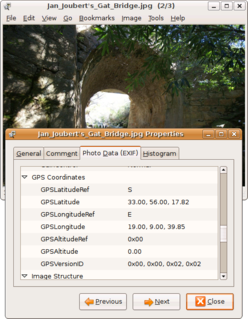
Geotagging, or GeoTagging, is the process of adding geographical identification metadata to various media such as a geotagged photograph or video, websites, SMS messages, QR Codes or RSS feeds and is a form of geospatial metadata. This data usually consists of latitude and longitude coordinates, though they can also include altitude, bearing, distance, accuracy data, and place names, and perhaps a time stamp.

ArcGIS Geographic information system maintained by Esri

ArcGIS is a geographic information system (GIS) for working with maps and geographic information maintained by the Environmental Systems Research Institute (Esri). It is used for creating and using maps, compiling geographic data, analyzing mapped information, sharing and discovering geographic information, using maps and geographic information in a range of applications, and managing geographic information in a database.

QGIS

QGIS is a free and open-source cross-platform desktop geographic information system (GIS) application that supports viewing, editing, and analysis of geospatial data.

Georeferencing means that the internal coordinate system of a map or aerial photo image can be related to a geographic coordinate system. The relevant coordinate transforms are typically stored within the image file, though there are many possible mechanisms for implementing georeferencing. The most visible effect of georeferencing is that display software can show ground coordinates and also measure ground distances and areas.

JTS Topology Suite is an open-source Java software library that provides an object model for Euclidean planar linear geometry together with a set of fundamental geometric functions. JTS is primarily intended to be used as a core component of vector-based geomatics software such as geographical information systems. It can also be used as a general-purpose library providing algorithms in computational geometry.

The concept of a Geospatial Web may have first been introduced by Dr. Charles Herring in his US DoD paper, An Architecture of Cyberspace: Spatialization of the Internet, 1994, U.S. Army Construction Engineering Research Laboratory.

ArcGIS Server is the core server geographic information system (GIS) software made by Esri. ArcGIS Server is used for creating and managing GIS Web services, applications, and data. ArcGIS Server is typically deployed on-premises within the organization’s service-oriented architecture (SOA) or off-premises in a cloud computing environment.

Reverse geocoding is the process of back (reverse) coding of a point location to a readable address or place name. This permits the identification of nearby street addresses, places, and/or areal subdivisions such as neighbourhoods, county, state, or country. Combined with geocoding and routing services, reverse geocoding is a critical component of mobile location-based services and Enhanced 911 to convert a coordinate obtained by GPS to a readable street address which is easier to understand by the end user, but not necessarily with a better accuracy.

In data analysis involving geographical locations, geo-imputation or geographical imputation methods are steps taken to replace missing values for exact locations with approximate locations derived from associated data. They assign a reasonable location or geographic based attribute to a person by using both the demographic characteristics of the person and the population characteristics from a larger geographic aggregate area in which the person was geocoded. For example, if a person's census tract was known and no other address information was available then geo-imputation methods could be used to probabilistically assign that person to a smaller geographic area, such as a census block group.

The Ricoh 500SE digital compact camera is suitable for outdoor photography and networkability. Capability includes external information such as GPS position or barcode numbers within the image headers. External vendors sell hardware and software for workflows involving GPS positioning or barcode scanning. Most NMEA compliant bluetooth GPS receivers can be used with this camera through its built in bluetooth communication capability. The body is resistant to dust and water, making it robust for many environments.

CrimeStat

CrimeStat is a crime mapping software program. CrimeStat is Windows-based program that conducts spatial and statistical analysis and is designed to interface with a geographic information system (GIS). The program is developed by Ned Levine & Associates under the direction of Ned Levine, with funding by the National Institute of Justice (NIJ), an agency of the United States Department of Justice. The program and manual are distributed for free by NIJ.

WorldMap

WorldMap is a web platform for creating, displaying, analyzing, and searching spatial data and other data forms across multiple disciplines.

In geographic information systems, toponym resolution is the relationship process between a toponym, i.e. the mention of a place, and an unambiguous spatial footprint of the same place.

CartoDB

CARTO is a Software as a Service (SaaS) cloud computing platform that provides GIS, web mapping, and spatial data science tools. The company is positioned as a Location Intelligence platform due to tools with an aptitude for data analysis and visualization that do not require previous GIS or development experience.

References

  1. https://pelias.io/
  2. "Geocode" term as a verb, as defined by Oxford English Dictionary at https://en.oxforddictionaries.com/definition/geocode
  3. "Geocode" term, as a noun, definition used by http://www.dictionary.com/browse/geocode
  4. Corbett, James P. Topological principles in cartography. Vol. 48. US Department of Commerce, Bureau of the Census, 1979.
  5. "Short CV" (PDF).
  6. Olivares, Miriam. "Geographic Information Systems at Yale: Geocoding Resources". guides.library.yale.edu. Retrieved 22 June 2016.
  7. "Spatially enabling the data: What is geocoding?". National Criminal Justice Reference Service. Retrieved 22 June 2016.
  8. "25th Anniversary of TIGER". census.maps.arcgis.com. Retrieved 22 June 2016.
  9. Google Maps
  10. Ratcliffe, Jerry H. (2001). "On the accuracy of TIGER-type geocoded address data in relation to cadastral and census areal units" (PDF). International Journal of Geographical Information Science. 15 (5): 473–485. doi:10.1080/13658810110047221. S2CID   14061774. Archived from the original (PDF) on 23 June 2006.
  11. Mazumdar S, Rushton G, Smith B et al.. Geocoding accuracy and the recovery of relationships between environmental exposures and health.International Journal of Health Geographics.2008;7:1–13. doi:10.1186/1476-072X-7-13. PMID   18387189.
  12. Hutchinson, Matthew J (2010). Developing an Agent-Based Framework for Intelligent Geocoding (PhD thesis). Curtin University.
  13. An Agent-Based Framework to Enable Intelligent Geocoding Services
  14. Jennifer Foreshew (24 November 2009). "Difficult addresses no problem for IntelliGeoLocator". The Australian. Retrieved 9 May 2011.
  15. Department of Education, Western Australia (April 2011). "X marks the spot". School Matters. Retrieved 9 May 2011.