
Dartmoor is an upland area in southern Devon, England. The moorland and surrounding land has been protected by National Park status since 1951. Dartmoor National Park covers 954 km2 (368 sq mi).

Dartmoor Preservation Association (DPA) is one of the oldest environmental or amenity bodies in the UK. It was founded in 1883. It concerns itself with Dartmoor, a National Park in Devon, south-west England. It began with two main areas of concern. Firstly, commoners' rights were being eroded through army use, including the firing of live artillery shells, and piecemeal enclosure of land around the margins. Secondly, there was increasing public interest in Dartmoor's scenery, archaeology, history and wildlife

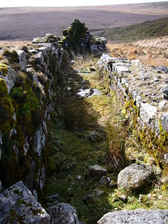
The Devonport Leat is a leat in Devon constructed in the 1790s to carry fresh drinking water from the high ground of Dartmoor to the expanding dockyards at Plymouth Dock.
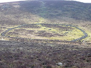
Grimspound is a late Bronze Age settlement, situated on Dartmoor in Devon, England. It consists of a set of 24 hut circles surrounded by a low stone wall. The name was first recorded by the Reverend Richard Polwhele in 1797; it was probably derived from the Anglo-Saxon god of war, Grim.
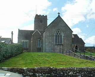
Holne is a village and civil parish on the southeastern slopes of Dartmoor in Devon, England. A community has existed here since at least the 11th century, and today a population of around 250 people is served by a church and a public house, the Church House Inn.

Yelverton is a large village on the south-western edge of Dartmoor, Devon, in England.

Bowerman's Nose is a stack of weathered granite on Dartmoor, Devon, England. It is situated on the northern slopes of Hayne Down, about a mile from Hound Tor and close to the village of Manaton at grid reference SX742805. It is about 21.5 feet (6.6 m) high and is the hard granite core of a former tor, standing above a 'clitter' of the blocks that have eroded and fallen from it.
The tin mining industry on Dartmoor, Devon, England, is thought to have originated in pre-Roman times, and continued right through to the 20th century, when the last commercially worked mine closed in November 1930. From the 12th century onwards tin mining was regulated by a stannary parliament which had its own laws.

Belstone is a small village and civil parish in the West Devon District of Devon, England. Lying on the northern side of Dartmoor, the western boundary of the parish is mostly formed by the East Okement River and the eastern by the River Taw; its highest point is Belstone Tor in the south, at 1,508 feet. The parish is surrounded, clockwise from the north, by the parishes of Sticklepath, South Tawton, Dartmoor Forest and Okehampton Hamlets. In 2001 its population was 257, relatively unchanged from the 1901 figure of 236.

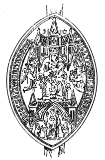
Crockern Tor is a tor in Dartmoor National Park, Devon, England. Composed of two large outcrops of rock, it is 396 metres above sea level. The lower outcrop was the open-air meeting place of the Stannary Convocation of Devon from the early 14th century until the first half of the 18th century. On Parliament Rock, pictured here, the Lord Warden of the Great Court of the Devon Tinners supposedly sat during meetings of the Court.

Ravenscroft School was an independent day and boarding school, initially for boys only, but from 1964 co-educational. From 1945 onwards its premises were in Somerset, England. It closed in July 1996, when most staff and pupils transferred to the new Farleigh College.

Roborough is a village in the South Hams of Devon, England. Former home of Plymouth City Airport, Roborough lies just outside the northern boundary of the city of Plymouth on the main road to Tavistock, and is a popular dormitory village.
The River Meavy is a river in the southwest part of Dartmoor in Devon in south-west England. It runs entirely in the national park and connects Burrator Reservoir to the River Plym.
Tavistock Abbey, also known as the Abbey of Saint Mary and Saint Rumon, is a ruined Benedictine abbey in Tavistock, Devon. Nothing remains of the abbey except the refectory, two gateways and a porch. The abbey church, dedicated to Our Lady and St Rumon, was destroyed by Danish raiders in 997 and rebuilt under Lyfing, the second abbot. The church was further rebuilt in 1285 and the greater part of the abbey between 1457 and 1458.

Brent Tor is a tor on the western edge of Dartmoor, approximately four miles (6.5 km) north of Tavistock, rising to 1100 ft (330m) above sea level. The Tor is surmounted by the Church of St Michael, the parish church of the village of Brentor, which lies below the Tor.

Wistman's Wood is one of three remote high-altitude oakwoods on Dartmoor, Devon, England.

Royal Air Force Harrowbeer or more simply RAF Harrowbeer is a former Royal Air Force station situated next to Yelverton in the parish of Buckland Monachorum, Devon, England
The Plymouth and Dartmoor Railway (P&DR) was a 4 ft 6 in gauge railway built to improve the economy of moorland areas around Princetown in Devon, England. Independent carriers operated horse-drawn wagons and paid the company a toll. It opened in 1823, and a number of short branches were built in the next few years.

The Princetown Railway was a 10¼ mile single track branch railway line in Devon, England, that ran from Yelverton on the Plymouth to Tavistock line, to Princetown via four intermediate stations, Dousland, Burrator and Sheepstor Halt, Ingra Tor Halt and King Tor Halt. The line closed in 1956 and today forms part of a popular cycling and walking route.

North Bovey is a village and civil parish situated on the south-eastern side of Dartmoor National Park, Devon, England, about 11 miles WSW of the city of Exeter and 1.5 miles SSW of Moretonhampstead. The village lies above the eastern bank of the River Bovey from which it takes its name. In 2001 the population of the parish was 274, compared to 418 in 1901 and 519 in 1801.
