
Isère is a landlocked department in the southeastern French region of Auvergne-Rhône-Alpes. Named after the river Isère, it had a population of 1,271,166 in 2019. Its prefecture is Grenoble. It borders Rhône to the northwest, Ain to the north, Savoie to the east, Hautes-Alpes to the south, Drôme and Ardèche to the southwest and Loire to the west.

Scrambling is a mountaineering term for ascending steep terrain using one's hands to assist in holds and balance. "A scramble" is a related term, denoting terrain that could be ascended in this way. It can be described as being between hiking and rock climbing.

Rhône-Alpes was an administrative region of France. Since 1 January 2016, it is part of the new region Auvergne-Rhône-Alpes. It is located on the eastern border of the country, towards the south. The region was named after the river Rhône and the Alps mountain range. Its capital, Lyon, is the second-largest metropolitan area in France after Paris. Rhône-Alpes has the sixth-largest economy of any European region.
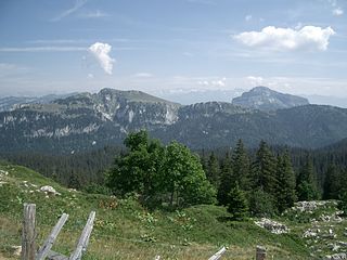
The Chartreuse Mountains are a mountain range in southeastern France, stretching from the city of Grenoble in the south to the Lac du Bourget in the north. They are part of the French Prealps, which continue as the Bauges to the north and the Vercors to the south.
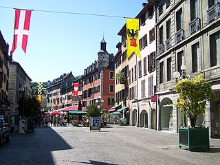
Chambéry is the prefecture and largest city of the Savoie department in the southeastern Auvergne-Rhône-Alpes region of France.

The Isère is a river in the Auvergne-Rhône-Alpes region of southeastern France. Its source, a glacier known as the Sources de l'Isère, lies in the Vanoise National Park in the Graian Alps of Savoie, near the ski resort in Val-d'Isère on the border with Italy. An important left-bank tributary of the Rhône, the Isère merges with it a few kilometers north of Valence.

A via ferrata is a protected climbing route found in the Alps and certain other Alpine locations. The protection includes steel fixtures such as cables and railings to arrest the effect of any fall, which the climber can either hold onto or clip into using climbing protection. Some via ferratas can also include steel fixtures that provide aid in overcoming the obstacles encountered, including steel ladders and steel steps.

The Rochers de Naye is a mountain of the Swiss Alps, overlooking Lake Geneva near Montreux and Villeneuve, in the canton of Vaud. They lie on the range separating the basin of Lake Geneva from the valley of the Sarine, on the watershed between the Rhone and the Rhine. The mountain is partially located in the canton of Fribourg, the border between the two cantons culminating on a lower summit named Grande Chaux de Naye.

Sixt-Fer-à-Cheval is a commune in the Haute-Savoie department within the Auvergne-Rhône-Alpes region in southeastern France. It is located at the end of the Giffre Valley.

Corbel is a commune in the Savoie department in the Auvergne-Rhône-Alpes region in south-eastern France. It borders the department of Isère.

Saint-Pierre-d'Entremont is a commune in the Savoie department in the Auvergne-Rhône-Alpes region in south-eastern France.

La Chapelle-d'Abondance is a commune in the Haute-Savoie department in the Auvergne-Rhône-Alpes region in south-eastern France.

Le Reposoir is a commune in the Haute-Savoie department in the Auvergne-Rhône-Alpes region in south-eastern France.
Saint-Pierre-d'Entremont is a commune in the Isère department in the Auvergne-Rhône-Alpes region in southeastern France.
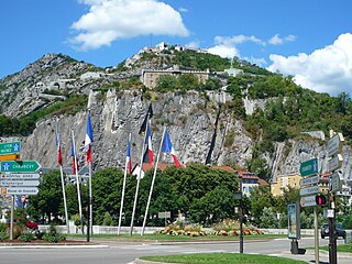
The Bastille is a fortress culminating at 476 m (1,561ft) above sea level, located at the south end of the Chartreuse mountain range and overlooking the city of Grenoble, France. The Bastille, which also gives its name to the hill, is the main tourist site of the Grenoble area, with 600,000 visitors per year.
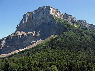
Mont Granier (1,933m) is a limestone mountain located between the départements of Savoie and Isère in France. It lies in the Chartreuse Mountains range of the French Prealps between the towns of Chapareillan and Entremont-le-Vieux. Its east face overlooks the valley of Grésivaudan and Combe de Savoie, and the north face overlooks Chambéry. At 900 meters tall, Mont Granier has one of the highest cliffs in France.

La Cochette is a mountain of the Chartreuse Mountains culminating at 1618 m above sea level and located at the edge of Corbel, of Saint-Jean-de-Couz and of Entremont-le-Vieux in Savoie.
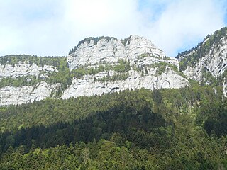
The Roc de Gleisin is a Massif de la Chartreuse mountain located between Entremont-le-Vieux and Saint-Pierre-d'Entremont in Savoie, eastern France. Rock bars on its western side also delimit the territory of Corbel district. The summit is 1,434 metres (4,705 ft) above sea level. The mountain is most composed of limestone.

The Col de la Cluse is a mountain pass located 1,169 m above sea level in the Chartreuse Mountains. It connects Le Désert d'Entremont to Corbel, Savoie, France. The main road of the pass is the D45.

Charmant Som is a mountain in the French department of Isère, rising to 1,867 metres (6,125 ft) in the Chartreuse Mountains in the Alps. It is made up of limestone, but its relief is less pronounced than that of the surrounding mountains, which is why it is covered with alpine meadows, the origin of its name. These have been occupied and tended by shepherds since the Middle Ages. They are accessible via a road built between the two world wars from the Col de Porte to 200 metres (660 ft) below the main summit. The road leads to two buildings serving as inn, chalet and cheese dairy.


