Related Research Articles
The Arabian Sea is a region of sea in the northern Indian Ocean, bounded on the west by the Arabian Peninsula, Gulf of Aden and Guardafui Channel, on the northwest by Gulf of Oman and Iran, on the north by Pakistan, on the east by India, and on the southeast by the Laccadive Sea and the Maldives, on the southwest by Somalia. Its total area is 3,862,000 km2 (1,491,000 sq mi) and its maximum depth is 4,652 meters (15,262 ft). The Gulf of Aden in the west connects the Arabian Sea to the Red Sea through the strait of Bab-el-Mandeb, and the Gulf of Oman is in the northwest, connecting it to the Persian Gulf.

Djibouti is a country in the Horn of Africa. It is bordered by Eritrea in the north, Ethiopia in the west and south, and Somalia in the southeast. To the east is its coastline on the Red Sea and the Gulf of Aden. Rainfall is sparse, and most of the territory has a semi-arid to arid environment. Lake Assal is a saline lake which lies 155 m (509 ft) below sea level, making it the lowest point on land in Africa and the third-lowest point on Earth after the Sea of Galilee and the Dead Sea. Djibouti has the fifth smallest population in Africa. Djibouti's major settlements include the capital Djibouti City, the port towns of Tadjoura and Obock, and the southern cities of Ali Sabieh and Dikhil. It is the forty-six country by area in Africa and 147st largest country in the world by land area, covering a total of 23,200 km2 (9,000 sq mi), of which 23,180 km2 (8,950 sq mi) is land and 20 km2 (7.7 sq mi) is water.

The Red Sea is a seawater inlet of the Indian Ocean, lying between Africa and Asia. Its connection to the ocean is in the south, through the Bab el Mandeb strait and the Gulf of Aden. To its north lie the Sinai Peninsula, the Gulf of Aqaba, and the Gulf of Suez. It is underlain by the Red Sea Rift, which is part of the Great Rift Valley.

The Gulf of Aden is a deepwater gulf of the Indian Ocean between Yemen to the north, the Arabian Sea to the east, Djibouti to the west, and the Guardafui Channel, Socotra and Somalia to the south. In the northwest, it connects with the Red Sea through the Bab-el-Mandeb strait, and it connects with the Arabian Sea to the east. To the west, it narrows into the Gulf of Tadjoura in Djibouti. The Aden Ridge lies along the middle of the Gulf and is causing it to widen about 15mm per year.

The Bab-el-Mandeb, or the Gate of Grief, is a strait between Yemen on the Arabian Peninsula, Djibouti, and Eritrea in the Horn of Africa. It connects the Red Sea to the Gulf of Aden.

Ethiopia is located in the Horn of Africa. It is bordered by Eritrea to the north, Djibouti and Somalia to the east, Sudan and South Sudan to the west, and Kenya to the south. Ethiopia has a high central plateau, the Abyssinian Highlands that varies from 1,290 to 3,000 m above sea level, with some 25 mountains whose peaks rise over 4,000 meters (13,200ft), the highest being Ras Dashen at 4,543 meters (14,538ft).

The Gulf of Suez is a gulf at the northern end of the Red Sea, to the west of the Sinai Peninsula. Situated to the east of the Sinai Peninsula is the smaller Gulf of Aqaba. The gulf was formed within a relatively young but now inactive Gulf of Suez Rift rift basin, dating back about 26 million years. It stretches some 300 kilometres (190 mi) north by northwest, terminating at the Egyptian city of Suez and the entrance to the Suez Canal. Along the mid-line of the gulf is the boundary between Africa and Asia. The entrance of the gulf lies atop the mature Gemsa oil and gas field. The gulf is considered one of the world's important maritime zones due to being an entrance to the Suez Canal.
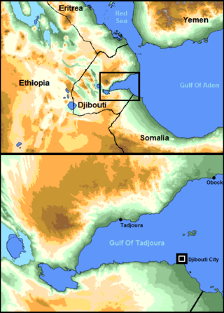
The Gulf of Tadjoura is a gulf or basin of the Indian Ocean in the Horn of Africa. It lies south of the straits of Bab-el-Mandeb, or the entrance to the Red Sea, at 11.7°N 43.0°E. The gulf has many fishing grounds, extensive coral reefs, and abundant pearl oysters. Most of its coastline is the territory of Djibouti, except for a short stretch on the southern shore, which is part of the territory of Somaliland.

Ras Muhammad is a national park in Egypt at the southern extreme of the Sinai Peninsula, overlooking the Gulf of Suez on the west and the Gulf of Aqaba to the east. The park is becoming a center of eco-tourism in the region.
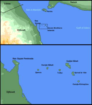
The Seven Brothers Islands, also known as the Sawabi Islands or Seba Islands, is an archipelago in the Dact-el-Mayun section of the Bab-el-Mandeb strait. They are within the Obock District of Djibouti, and are a notable diving site. Even in English publications, the group is often called by its French name, Sept Frères.
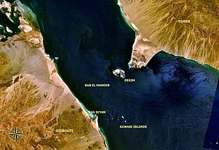
The Bab Iskender (Arabic: باب اسكندر Iskander's Strait, also variously known as the Eastern strait, the small strait, the narrow pass or the small pass, is the eastern section of the Bab-el-Mandeb straits, which separates Ras Menheli, Yemen, on the Arabian Peninsula from Ras Siyyan, Djibouti, on the Horn of Africa. The strait is 2 miles wide and 16 fathoms deep. The Yemeni island of Perim divides the strait into two channels, Bab Iskender and Dact-el-Mayun respectively.
The Dact-el-Mayun, also known as the Western strait, the large strait, the large pass or the wide pass, is the western section of the Bab-el-Mandeb straits, which separates Ras Menheli, Yemen, on the Arabian Peninsula from Ras Siyyan, Djibouti, on the Horn of Africa. The strait has a width of about 16 miles (26 km) and a depth of 170 fathoms (310 m). The Yemeni island of Perim divides the strait into two channels, Bab Iskender and Dact-el-Mayun respectively.
Ras Siyyan or Ras Siyan is a peninsula in the Obock Region of Djibouti, on the Bab-el-Mandeb strait, about 20 km southwest of Perim Island.
Berenice Epideires, or "Berenice upon the Neck of Land", was a town on the western shore of the Red Sea. It was located near the Bab-el-Mandeb strait, in modern-day Djibouti. The settlement's position on a sandy spit or promontory was the cause of its distinctive appellation. Some authorities, however, attribute the name to the neighborhood of a more considerable town named Deirê on the Ras Siyyan peninsula. Strabon mentions the mangroves that were found there on the coast. Ptolemy II Philadelphus favored the settlement thus naming after his sister Berenice. The inhabitants of the nation were known as the Ichthyophagi who inhabited the country and were recorded to have practiced male circumcision. It is said there is a pillar of Sesostris, on which is inscribed, in hieroglyphics, an account of his passage. For he appears to have subdued first Ethiopia and Troglodytica, and afterwards to have passed over into Arabia.
The Bridge of the Horns is a proposed construction project to build a bridge between the coasts of Djibouti and Yemen, across the Bab-el-Mandeb, between the Red Sea and Gulf of Aden. It would be constructed by Al Noor Holding Investment and would have six lane highway and quadruple-track railway in the centre of highway. In 2010, it was announced that Phase I had been delayed. As of August 2023, nothing more has been heard of the project, and it is currently presumed to be indefinitely suspended or cancelled.

Djibouti, officially the Republic of Djibouti, is a country in the Horn of Africa, bordered by Somalia to the south, Ethiopia to the southwest, Eritrea in the north, and the Red Sea and the Gulf of Aden to the east. The country has an area of 23,200 km2 (8,958 sq mi).
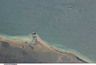
Fagal is a coastal location in eastern Djibouti. It lies north of Obock. It lies along the N15 road, connected to the Eritrean border at Rahayta to the north. The peninsula strip nearby is called the Ras Siyyan. Just to the south is Herkale Airport and the village of Khor `Angar.
The Mabla Mountains are a mountain range in the northern Obock and Tadjoura Region of Djibouti. The endemic Djibouti spurfowl makes its home here as well as in the Forêt du Day. With a mean height of 1370 metres, is the fifth highest point in Djibouti.
Siyyan Himar or Rocher Moulhele is a pair of small islands, about 100 m apart and rising only 1.8 m above sea level, located about 3.8 km off the coast of Djibouti and 4.4 km northeast of the Siyyan peninsula, in the Bab-el-Mandeb strait. They are an uplifted ridge of a fossil coral reef.
The Port of Doraleh is an extension of the Port of Djibouti, located 5 km west of Djibouti City. The multipurpose port has terminals for handling oil, bulk cargo, containers and livestock. It was partially owned and operated by DP World and China Merchants Holdings, until its container facility was seized by the government of Djibouti in February 2018. There is a Chinese naval base directly adjacent to the port. China’s first overseas military base is in close proximity to the port.
References
- ↑ Sailing Directions (Enroute) - Red Sea and Persian Gulf , page 161. National Geospatial Intelligence Agency pub. 172. Accessed 2012-07-6.
12°28′11″N43°18′30″E / 12.4696°N 43.3083°E
| | This Djibouti location article is a stub. You can help Wikipedia by expanding it. |